
Waters to the south of the UK are currently experiencing a significant marine heatwave, with the conditions expected to persist and intensify over the coming week.
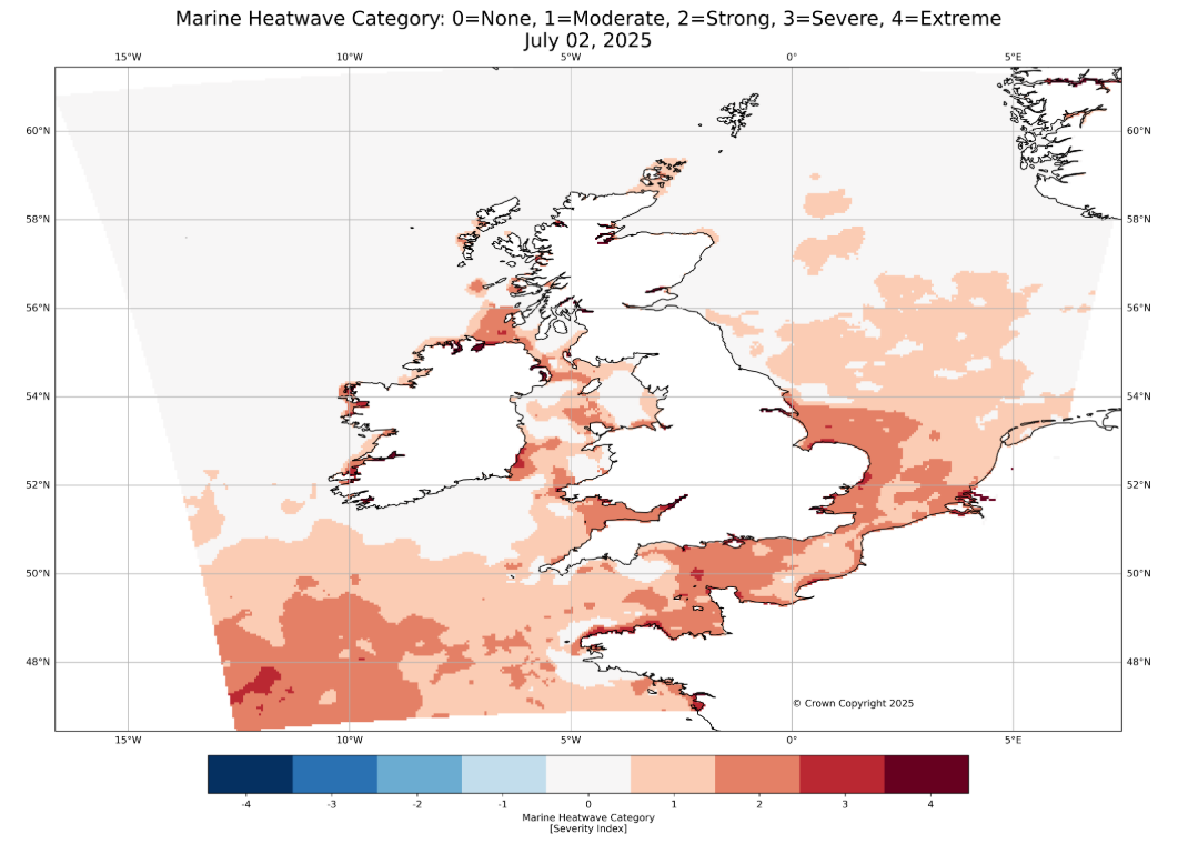
The south of the UK is currently experiencing a significant marine heatwave (MHW), with sea surface temperatures in the Celtic Sea, English Channel, and Southern North Sea registering anomalies of 1.5°C to 3°C above 1982-2012 average. These conditions, classified as moderate to strong marine heatwaves, are expected to persist and intensify, particularly in the Celtic Sea and western English Channel, over the coming week.
Sea surface temperatures across the Northwest European shelf seas have reached an average of 14.6°C, making this the third warmest July 1st temperature on record, behind 2009, and 2023. These temperatures are more typical of early August in the 1980s and 1990s. In-situ observations, such as those from the E1 buoy near Plymouth, confirm the persistence of these elevated temperatures, with only 15 days in June falling within the ‘normal’ range.
There have been at least patches of marine heatwaves in the Northwest European seas since the start of the year. The first half of June saw a temporary reprieve, with cooler conditions prevailing due to a lack of sunshine and persistent westerly winds. These weather patterns helped limit ocean warming, offering a brief period of relief from elevated sea temperatures.
However, in the second half of June, anticyclonic conditions and a developing land heatwave, particularly over France and the southeast of the UK, led to renewed ocean warming. Increased sunshine and weaker winds allowed sea surface temperatures to rise again, pushing the English Channel, Southern North Sea (including the coast of East Anglia), and parts of the Celtic Sea back into a moderate to strong marine heatwave state. The most pronounced anomalies have been observed offshore Cornwall and along the coast of East Anglia.
The Bay of Biscay and Northwest Mediterranean are currently the most affected regions, with anomalies reaching 2°C to 5°C.
What are marine heatwaves?
Marine heatwaves are defined as prolonged periods of unusually high sea surface temperatures relative to the expected variability for the time of year. This definition is based on the first 30 years of satellite data from 1982 to 2012 and helps identify significant deviations from historical norms. These events are often linked to calm, settled weather and are becoming more frequent and intense due to global climate change.
Climate change and ocean warming
The global ocean has absorbed over 90% of the excess heat from greenhouse gas emissions, with the upper layers storing as much heat as the entire atmosphere. This long-term warming trend is evident in the increasing frequency of marine heatwaves and the near absence of marine cold spells in recent years.
The Met Office uses a combination of satellite and in-situ observations, including buoys, floats, and ships, to monitor sea temperatures. The OSTIA system (Operational Sea Surface Temperature and Sea Ice Analysis) blends these data sources into a daily gridded dataset, enabling consistent tracking of ocean temperature changes.
Impacts and risks
Marine heatwaves can have wide-ranging impacts. Warmer seas can amplify land heatwaves by reducing the cooling effect of sea breezes and can fuel extreme rainfall events under the right atmospheric conditions.
The Marine Biological Association and the Centre for Environment, Fisheries, and Aquatculture ScienceS indicated that marine ecosystems are also at risk, with potential for harmful algal blooms and stress on species such as mussels, oysters, and salmon. While some species may suffer, others, like bluefin tuna, sea bass, jellyfish, and stingrays, may thrive and expand their range.
Marine heatwaves can also pose a hidden threat to public health by increasing the risk of infectious diseases. During the 2018 UK marine heatwave, elevated levels of pathogenic Vibrio species were detected in seawater and shellfish at several locations across the UK.
If greenhouse gas emissions are not significantly reduced, models suggest that permanent marine heatwave conditions could become a reality by mid-century. For now, while the warmer waters may seem inviting, swimmers are advised to remain cautious, as sea temperatures still lag behind peak summer levels and can pose a risk when air temperatures are high.
Keep up to date with weather warnings, and you can find the latest forecast on our website, on YouTube, by following us on X and Facebook, as well as on our mobile app which is available for iPhone from the App store and for Android from the Google Play store.