How is Summer 2025 shaping up so far?
As we reach the midpoint of meteorological summer, it’s clear this year has been far from ordinary.
From record-breaking warmth and prolonged dry spells to back-to-back heatwaves, the UK’s weather has been making headlines and prompting some to ask, is this ‘just summer’?
Yesterday, further drought declarations were issued across parts of the UK, following what has been the driest January to June for England since 1976. This past weekend saw the third official heatwave of the summer, and temperatures are set to rise again at the end of this week.
Spring 2025 was exceptional, going down as the UK’s warmest and sunniest on record. June followed suit, becoming the warmest June ever recorded in England, and the second warmest for the UK in records since 1884.
So how is summer looking at the halfway point?
Above average temperatures
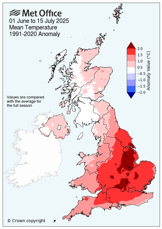
Provisional Met Office data up until (and including) 15 July shows that the UK’s average mean temperature so far this summer sits 1.14°C above the long-term meteorological average for summer. England in particular has been well above average (1.58°C), whilst Scotland and Northern Ireland have remained closer to their seasonal averages.
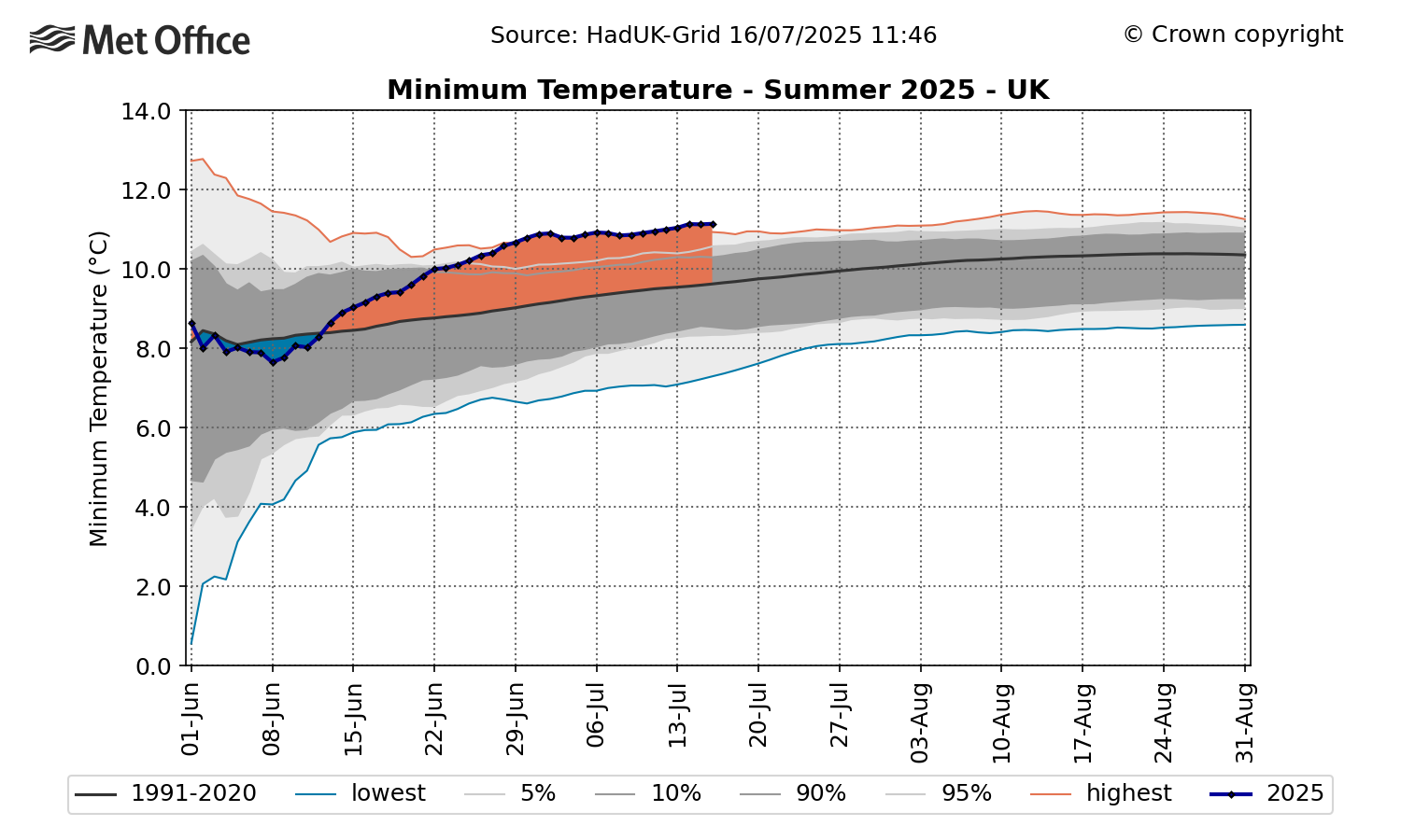
Daily minimum temperatures (the lowest temperature recorded during the 24-hour period from 09:00-09:00) are currently tracking well above average (0.78°C) for this point in the summer. The graph below, based on data from 1931, illustrates this.
Daily maximum temperatures (the highest temperature recorded during the 24-hour period from 09:00-09:00) are also tracking above average – 1.53°C as of the 15 July. England has seen especially high maximum temperatures, up 2.14°C on its summer average.
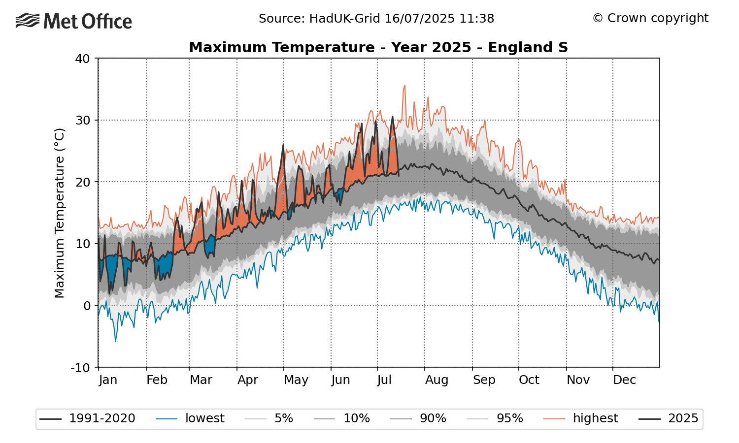
The graph below illustrates how daily maximum temperatures have been well above average across southern England since the start of spring. This has been in part, due to the three official heatwaves we have already seen this summer which can be seen on this chart.
So far, there have been 11 days in 2025 where temperatures have reached 30°C or higher. Based on station observations from 1931, this has only happened twice before up to this point in the summer - in 1976 and 2018.
The highest temperature of the year so far, 35.8°C, was reached on 1 July at Faversham in Kent. This remains below the UK’s all-time high of 40.3°C, recorded in Coningsby, Lincolnshire, in July 2022. Temperatures reaching the low to mid 30s is becoming increasingly frequent as our climate continues to warm.
Read: The UK's longest heatwave events and where they happened
More heatwaves on the horizon
As the climate continues to change, the UK is likely to see more frequent and intense heatwaves. A new Met Office study released in June highlights how UK heatwaves could become longer and hotter due to escalating climate trends, with an estimated 50-50 chance of seeing 40°C again in the UK in the next 12 years.
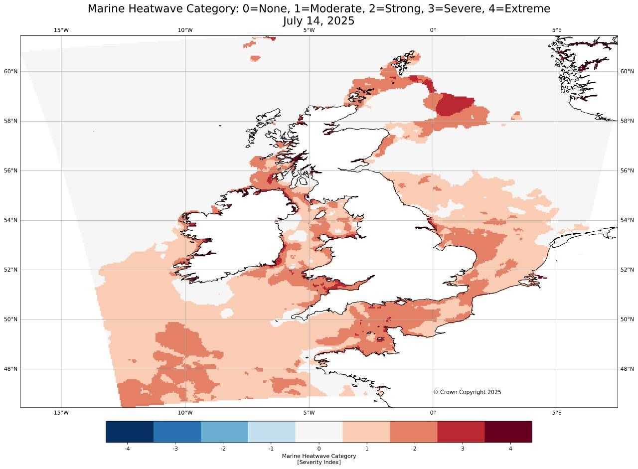
A heatwave in the water continues
The UK continues to experience a significant marine heatwave at the moment, with the intensification linked with the land heatwave that we experienced last week. Marine heatwave conditions are likely to ease a little southwest of the UK in the coming days, as westerly winds strengthen. Sea temperatures will continue to increase in the central and northern North Sea however.
The map below shows conditions around the UK on 14 July 2025.
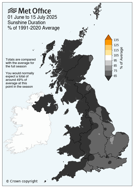
Above average sunshine
All four UK nations have recorded above average sunshine so far this summer, with Northern Ireland seeing the least. This continues the theme from spring, which was also exceptionally sunny.
Rainfall deficit persisting from spring
Following an extremely dry spring, summer rainfall has remained just below average across the UK, with 45% of the whole summer’s long-term average recorded.
However, regional variation is significant. Large areas of eastern Wales and England have received less than 30% of their average summer rainfall whereas in contrast, parts of Cumbria have already received close to their full summer average, and we’re only halfway through the season.
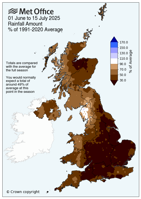
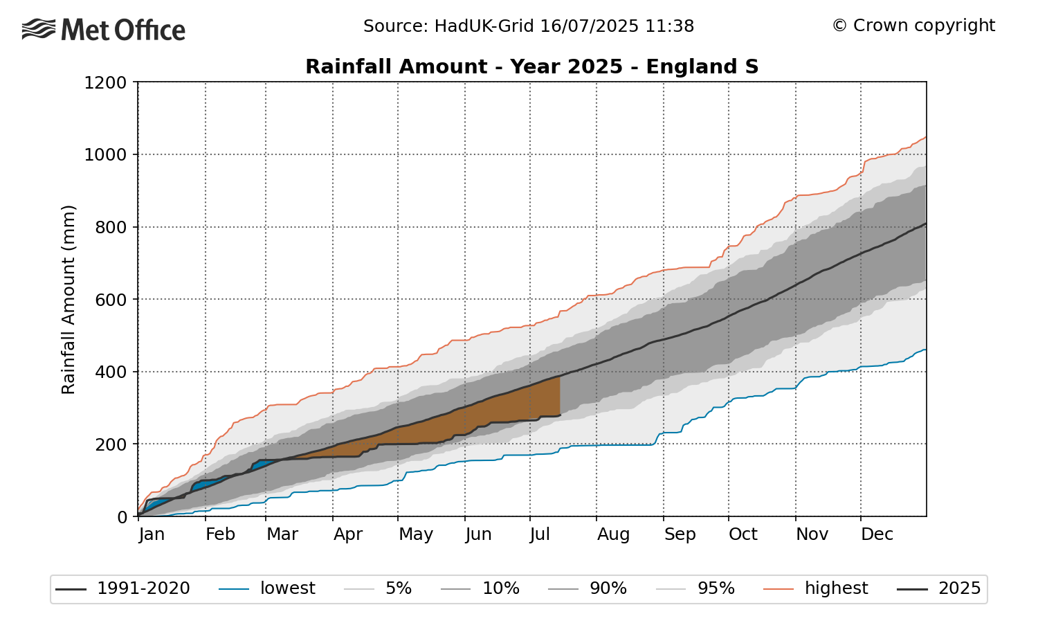
England has been the driest of the four UK nations, recording just 37% of its average rainfall for the whole of summer. There’s also a clear contrast between north and south, with southern England seeing 29% compared to northern England at 49%. Of particular note is the fact that the rainfall deficits that have built up through the spring have persisted and increased further in summer so far.
This is illustrated by the below graph, which shows how the rainfall deficit has built up across southern England so far this year.
Met Office scientist Emily Carlisle explains: “It’s hard to say this summer has been typical so far when we look at the statistics. June was the warmest on record for England, with our records going back to 1884. That warmth has continued into July, with three heatwaves so far this summer and temperatures rising again later this week. There is of course, still a month-and-a-half of meteorological summer to go, so plenty of time for things to change.”
Why has it been so hot?
Several factors have contributed to the unusual warmth:
-
Persistent high pressure: A dominant high-pressure system has been sitting over the UK, squashing the air and causing sinking air that suppresses cloud formation. This results in clear skies and strong sunshine, which heat the ground. With little wind and continued sunshine each day, temperatures build up over time.
-
Dry ground: The extremely dry spring has left soils parched. With less moisture available for evaporation, more solar energy goes directly into heating the air.
-
Marine heatwave: Sea surface temperatures around the UK are currently well above average. As air passes over these warmer waters, it retains more heat.
-
Climate change: The UK is warming. The newly released State of the UK Climate Report 2024 shows the UK is warming at a rate of approximately 0.25°C per decade. 2023, 2022 and 2018 are among the UK’s top-ten warmest summers in records back to 1884.
What’s Next?
Looking ahead, the latter part of July and early August are expected to bring more typical British summer weather - changeable conditions with a mix of rain and sunshine. While confidence in long-range forecasts naturally decreases the further away we look, this outlook aligns with seasonal expectations.
Read: From heatwaves to downpours: July’s historical weather records
Read: How do we know when weather records are broken?