Thunderstorm warnings – August 2020
Author: Press Office
12:09 (UTC+1) on Mon 10 Aug 2020
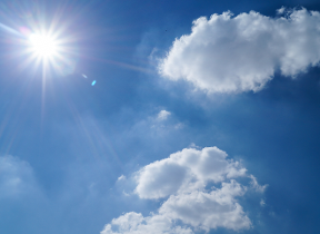
The hot weather will continue across the UK, with heatwave conditions for many, creating ideal conditions for thunderstorms which will bring heavy rain and increasing risks from flash flooding, lightning and hail..
National Severe Weather Warning
Yellow thunderstorm warnings are in place across the country between now and Thursday.
Today, thunderstorm warnings cover much of the UK. Northern Scotland is at risk of heavy showers, frequent lightning and gusty winds with 30 to 40mm of rain possible in an hour.
"A second yellow thunderstorm warning is also in place for parts of North West England, North Wales. The worst of the storms are likely to occur in the West Midlands. Here, exceptional rainfall totals could be seen of 60mm in an hour; with a very small chance of 150mm of rainfall in 3 or 4 hours”. " - Chief Meteorologist Steve Ramsdale.
⚠️ Yellow Weather Warning Issued ⚠️
— Met Office (@metoffice) August 10, 2020
Severe thunderstorms across parts of the northwest Monday 1600 – Tuesday 0300
Latest info 👉 https://t.co/QwDLMfRBfs
Stay #WeatherAware pic.twitter.com/sSjUKuFk6W
Flood risk
Caroline Douglass, Flood Duty Manager at the Environment Agency, said: “Heavy thunderstorms across the Midlands and the north-west of England could lead to surface water and river flooding in some communities, with possible disruption to travel and flooding of individual properties this afternoon and into early Tuesday morning. Isolated flooding is possible across England until Thursday, due to further heavy thunderstorms.
Our teams are ready to respond where needed. We urge people to check their flood risk, sign up for free flood warnings and keep up to date with the latest situation online. Call Floodline on 0345 988 1188 or follow @EnvAgency on Twitter for the latest flood updates.”
Heatwave conditions
The hot weather will continue for much of the week with heatwave conditions persisting in parts of southern and central England. Here, temperatures will locally reach mid - high 30s°C . Although for much of the week, temperatures will start to fall from their peak from Thursday onwards. Overnight temperatures will also be high for many.
Friday saw 36.4°C recorded at Heathrow and Kew Gardens, the hottest August day since 10th August 2003 (38.5°C, Faversham). Whereas on on the weekend, 34.5°C was recorded on Saturday, and 34°C was recorded on Sunday.
Highest temperature on record
The highest temperature on record for the UK was 38.7°C, recorded at Cambridge Botanic Garden on the 25th July last year. While the hottest August day on record is 38.5C recorded at Faversham on 10th August 2003).
Heat Health Alert
The hot weather has resulted in Public Health England issuing heat health alerts for parts of England into next week.
Stay cool
There are tips on staying cool in hot weather on the Met Office website. With strong summer sunshine at this time of year, UV levels will be high in some areas and you can check the UV forecast for your area here.
Extreme weather and climate change
Heatwaves are extreme weather events, but research shows that climate change is making these events more likely. A scientific study by the Met Office into the Summer 2018 heatwave in the UK showed that it was 30 times more likely to occur now than in 1750. This is due to the higher concentration of carbon dioxide (a greenhouse gas) in the atmosphere. As greenhouse gas concentrations increase, heatwaves of similar intensity are projected to become even more frequent perhaps occurring as regularly as every other year. The Earth’s surface temperature has risen by 1°C since the pre-industrial period (1850-1900).
Stay connected
You can check the latest weather warnings on our severe weather warnings pages. What is more, you can get the most accurate and up to date forecast for your area by using our forecast pages. Follow us on Twitter and Facebook. Our mobile app is available for iPhone from the App store and for Android from the Google Play store.
Government guidelines
Whatever the weather we are all being urged to remember the Government Coronavirus guidelines.