Thunderstorms and heatwave conditions – August 2020
Author: Press Office
15:32 (UTC+1) on Thu 13 Aug 2020
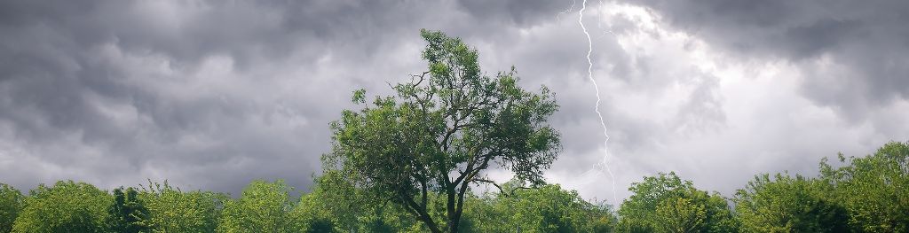
Thunderstorm warnings continue across much of the UK until Monday, 17th August, with a risk of impacts from heavy rain, flash flooding, lightning and hail.
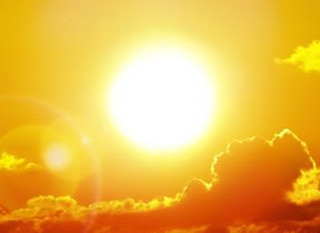
Hot weather and thunderstorms
The current hot weather creates ideal conditions for thunderstorms. Chief Meteorologist Frank Saunders says: “Up until Monday Thunderstorm warnings cover much of England and Wales, with parts of southern England and South Wales seeing the greatest likelihood of impacts. The storms will not affect all areas, but where they happen there will be frequent lightning, gusty winds and intense, heavy downpours with 30 to 40mm of rain possible in less than an hour and, in a few unlucky spots, a small chance of 60 mm falling in a short period.
“With the continuing hot weather, large swathes of the UK continue to be at risk from thunderstorms, and potentially the impacts from heavy rain, into the early part of next week.”
Parts of the UK have witnessed impacts from heavy, intense rainfall: Wales on Monday; Scotland on Tuesday night; and England on Wednesday.
The Environment Agency
Neil Davies, Flood Duty Manager at the Environment Agency, said: “Isolated thunderstorms could bring sudden surface-water and river flooding, which may lead to flooded properties and severe travel disruption in some areas. Further surface water and river flooding is also a possibility until Sunday.
“Environment Agency teams are working hard alongside local authorities to reduce the risk of flooding and keep communities safe, clearing grills and weed screens in areas which may be affected by heavy showers, and are ready to respond and support where needed. We urge people to check their flood risk, sign up for free flood warnings and keep up to date with the latest situation at Gov.uk, call Floodline on 0345 988 1188 or follow @EnvAgency on Twitter for the latest flood updates.”
Warm and humid
Frank Saunders added: “The hot weather is slowly subsiding now, with more cloud, but it will still be very warm and humid where the sun comes out in the south and west of the UK.
“In contrast to the last few days, maximum daytime temperatures will be reducing, with only isolated locations seeing temperatures of 30.0°C or above. And some northern and easterns areas much less warm at times, with a lot of low cloud and hill fog.”
Tropical nights
Overnight temperatures will also reduce with few if any locations recording temperatures of 20.0 C or more – so-called Tropical Nights. So far, this month we have seen five tropical nights 8th, 10th, 11th, 12th, and 13th there was also a Tropical Night on June 25th, making six so far this year. Between 1961 and 1990 there were no less than 44 Tropical Nights, between 2008 and 2017 there were 12, five in 2018 and four in 2019.
Heat Health Alerts
The hot weather has resulted in Public Health England issuing heat health alerts for parts of England into next week. There are tips on staying cool in hot weather on the Met Office website. With strong summer sunshine at this time of year, UV levels will be high in some areas and you can check the UV forecast for your area here.
Friday saw 36.4 °C recorded at Heathrow and Kew Gardens, the hottest August day since 10th August 2003 (38.5 °C, Faversham), while 34.5 °C was recorded on Saturday and 34.0 °C on Sunday.
The highest temperature on record for the UK was 38.7 °C recorded at Cambridge Botanic Garden on the 25th July last year, while the hottest August day on record is 38.5 °C recorded at Faversham on 10th August 2003).
Extreme weather and climate change
Heatwaves are extreme weather events, but research shows that climate change is making these events more likely. A scientific study by the Met Office into the Summer 2018 heatwave in the UK showed that it was 30 times more likely to occur now than in 1750 because of the higher concentration of carbon dioxide (a greenhouse gas) in the atmosphere. As greenhouse gas concentrations increase heatwaves of similar intensity are projected to become even more frequent, perhaps occurring as regularly as every other year. The Earth’s surface temperature has risen by 1.0°C since the pre-industrial period (1850-1900).
Stay connected
You can check the latest weather warnings on our severe weather warnings pages and you can get the most accurate and up to date forecast for your area using our forecast pages and by following us on Twitter and Facebook, as well as using our mobile app which is available for iPhone from the App store and for Android from the Google Play store.
Whatever the weather we are all being urged to remember the Government Coronavirus guidelines.