
England’s warmest June on record – the second warmest for the UK and Wales
The exceptional warmth was driven by an intense and record-breaking heatwave at the end of the month, following a much cooler and unsettled start.
Provisional Met Office statistics show that June 2026 was England’s warmest June on record for average mean temperature, while the UK and Wales recorded their second warmest June in a series dating back to 1884.
A defining feature of the month’s heatwave was the exceptionally warm overnight temperatures, with frequent ‘tropical nights’ helping to drive the highest average June minimum temperatures on record for the UK, England and Wales. Scotland recorded its joint highest on record.
One of the warmest Junes for average mean, maximum and minimum temperatures
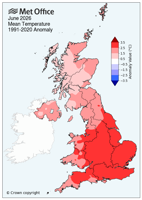
Provisional mean temperature statistics highlight the exceptional nature of the month. England recorded its warmest June on record, with a mean temperature of 17.1°C, surpassing the previous record set in 2025 and standing nearly 3°C above the long-term average.
For the UK, June 2026 provisionally ranks as the second warmest June on record, behind only June 2023. Wales recorded its second warmest, while Scotland and Northern Ireland both saw their joint fourth warmest June since 1884.
Met Office Scientist Dr Emily Carlisle said: “June’s high temperatures are part of a broader pattern of warmth during 2026. So far, five of the first six months of the year have recorded mean temperatures at least 1°C above average, with only January seeing below-average temperatures.”
Spring this year was the warmest on record for England and Wales, and the third warmest for the UK, due in part to an exceptionally early and record-breaking heatwave at the end of May.
A month of two halves
The first half of June was dominated by a westerly Atlantic pattern, bringing a succession of low-pressure systems and associated fronts across the UK. This resulted in generally cloudy, unsettled conditions, with most areas seeing rain on many days in the first half of the month.
Conditions began to shift around mid-month, as high pressure built over continental Europe, allowing much warmer air to be drawn northwards towards the UK.
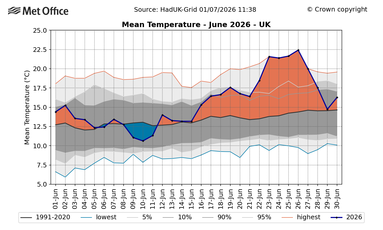
This graph shows the sharp rise in mean temperatures from the middle of June.
Exceptional late June heatwave
The second half of June is likely to be remembered for the exceptionally hot and humid heatwave that delivered record-breaking June temperatures and unprecedented overnight warmth in many areas. This was the first time since extreme heat warnings were introduced to the weather warnings system in 2021, that a Red Warning for Extreme Heat was issued for three consecutive days in the UK, with the extent and persistence of the heat particularly notable. Records dating back several decades, in some cases over a century, were challenged or exceeded during this event.
READ: June 2026 heatwave: A recap of the temperature records
Alongside the high daytime temperatures, the heatwave was notable for exceptionally warm nights. The UK, England and Wales all recorded their highest average minimum temperature for June since records began in 1884, each surpassing the previous record by around 0.5°C. Scotland also recorded its joint highest June average minimum temperature on record.
June 2026's minimum temperature was more than 2°C above average across the UK, while England recorded overnight temperatures 2.6°C above average.
Northern Ireland saw its second highest minimum temperature since 1884.
This map ranks June 2026's average minimum temperature against every previous June for each county, using records back to 1884.
Average maximum temperatures were also high, with the UK and England experiencing their joint third highest maximum temperature since 1884 and Wales its joint seventh highest. Although we experienced record-breaking high temperatures towards the end of the month, these averages are pulled down due to below-average temperatures at the beginning of the month.
Met Office Scientist Dr Emily Carlisle said: “This June is a clear example of how UK weather can deliver both unsettled conditions and record-breaking heat within the same month. The intensity of the late June heatwave, combined with exceptionally warm nights, has driven England’s warmest June on record for mean temperature, while the UK and Wales recorded their second warmest June on record.
Coming 50 years after the 1976 heatwave, it also highlights how similar events are now playing out in a warmer climate, with higher temperatures and more widespread impacts than we would have seen in the past.”
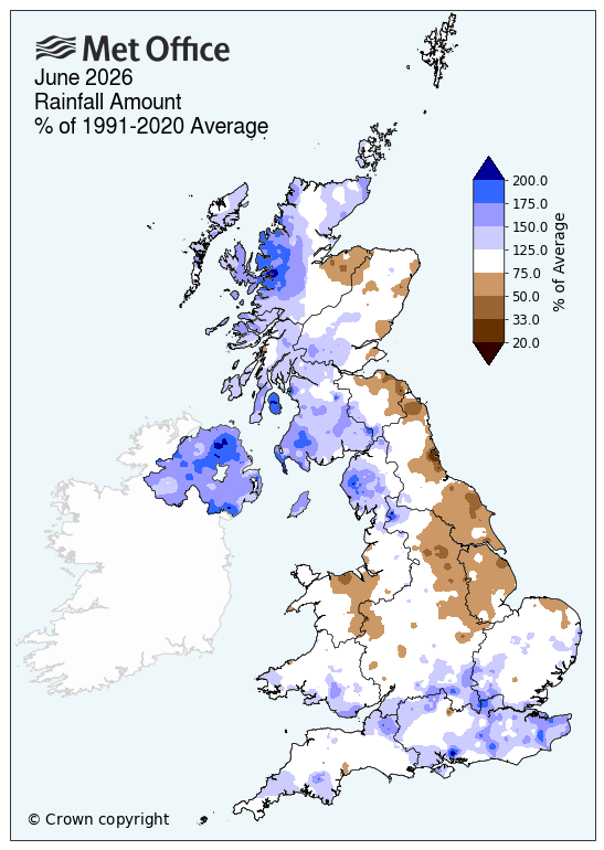
Rainfall: above average for the UK, but with regional variation
Despite the exceptional heat later in the month, June was wetter than average for the UK and all four nations. Northern Ireland was particularly wet, recording 67% more rainfall than average.
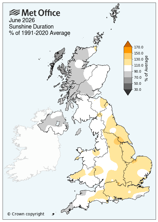
Sunshine: above average for the UK, but below for Scotland and Northern Ireland
Sunshine totals were above average for the UK, England and Wales, although not by as much as might be expected given the intensity of the late-month heatwave. The high humidity meant skies were often hazier and cloudier than during a less humid heatwave, limiting sunshine totals despite the exceptional temperatures.
Scotland and Northern Ireland recorded below average sunshine totals.
June heat and climate change
As high temperature records are continuing to be broken, the influence of climate change is under the microscope.
Professor Stephen Belcher CBE, Met Office Chief Scientist, said: “June’s heatwave was a significant weather event, with a Red Extreme Heat Warning issued. Human-induced climate change has made events like this more likely and more intense.
"To see temperatures like this in the UK in June is sobering. Events like this bring home the implications of climate change, with very high temperatures and humidity bringing significant health implications from heat stress, as well as impacts to a range of sectors such as transport, energy and water supply.”
The frequency and intensity of heatwaves has increased worldwide. Met Office projections indicate that hot spells will become more frequent in our future climate, particularly over the south-east of the UK. Temperatures are projected to rise in all seasons, but the heat would be most intense in summer.
Last week, Met Office scientists highlighted how heatwaves such as this one in June are becoming more likely and more intense, with a plausible future scenario showing UK temperatures could reach 45°C by the 2050s.
READ: UK could see 45°C by 2056, scientists reflect on 1976 heatwave anniversary
Looking beyond specific heatwaves, the Met Office’s HadUK-Grid dataset shows how June’s mean maximum temperatures have shifted since 1884.
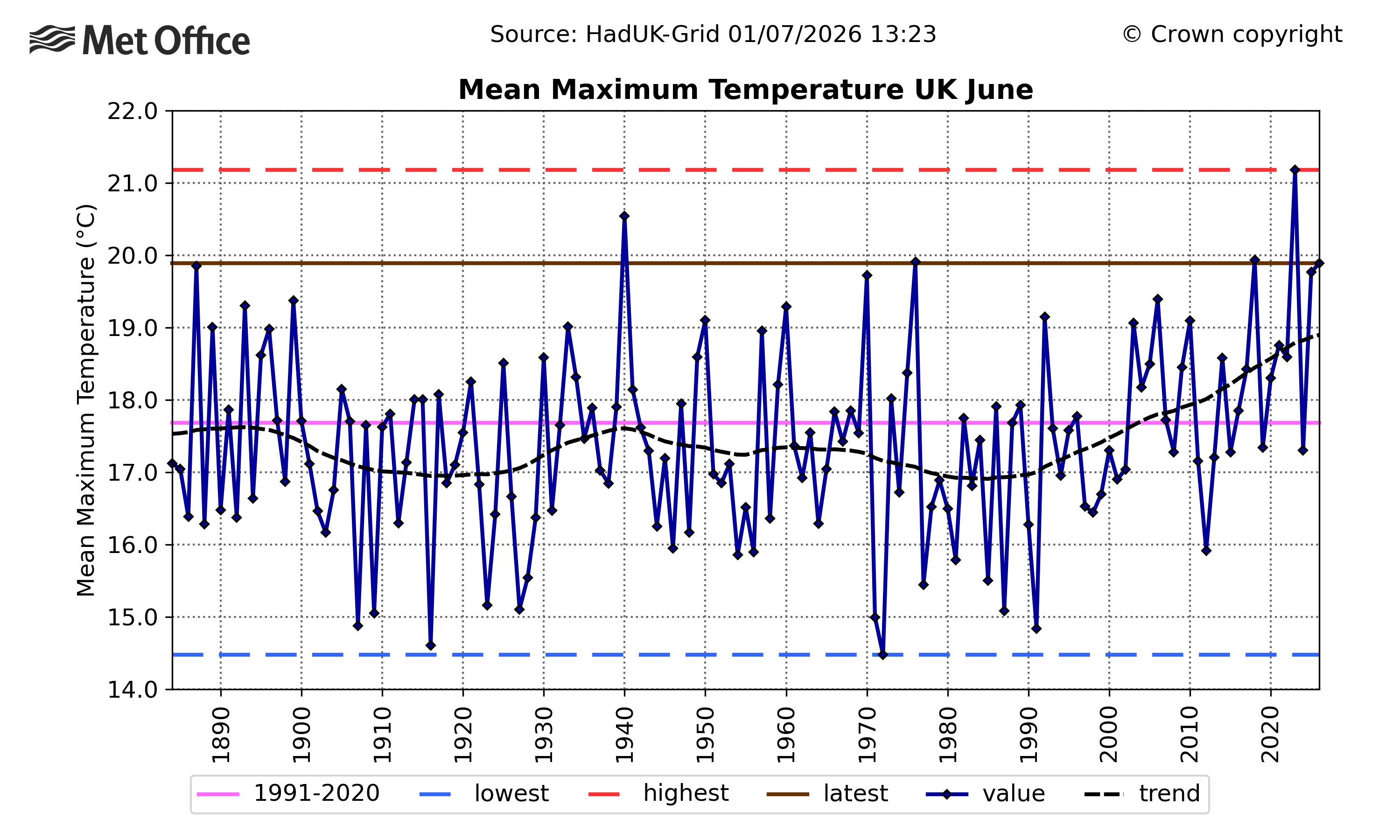
This graph shows mean maximum temperature in the UK in June since 1884.
Despite year-to-year variability, the average monthly maximum temperature for June has generally been rising and 2023 remains the warmest June on record for average maximum temperature.
Provisional June 2026 statistics
|
Provisional June 26 stats |
Mean temp (°C) |
Rainfall (mm/%) |
Sunshine (hours/ %) |
|||
|
|
Actual |
91/20 anomaly |
Actual |
91/20 anomaly |
Actual |
91/20 anomaly |
|
UK |
15.6 |
2.2 |
90.6 |
117 |
178.4 |
104 |
|
England |
17.1 |
2.8 |
67.8 |
104 |
210.4 |
112 |
|
Wales |
15.9 |
2.5 |
97.8 |
106 |
185.6 |
104 |
|
Scotland |
13.0 |
1.4 |
118.7 |
128 |
131.1 |
90 |
|
Northern Ireland |
14.6 |
1.6 |
135.6 |
167 |
133.0 |
89 |
Where does the monthly data come from?
The Met Office’s monthly climate statistics use HadUK‑Grid data to work out county, regional and UK‑wide averages. The dataset takes weather observations from across the country and interpolates them across the UK onto a 1km x 1km grid, covering every part of the UK. Some of these records stretch all the way back to 1836, meaning almost 200 years of weather data.
READ MORE: How do we know when weather records are broken?
READ MORE: What is HadUK-Grid?