Every few years the climate undergoes natural fluctuations, centred in the equatorial Pacific Ocean but with global consequences.
These El Niño–Southern Oscillation (ENSO) events involve changes in seawater temperatures and atmospheric pressures across the central and eastern tropical Pacific Ocean and result in warm El Niño phases and cold La Niña phases that each occur every few years and reach peak intensity in northern hemisphere winters.

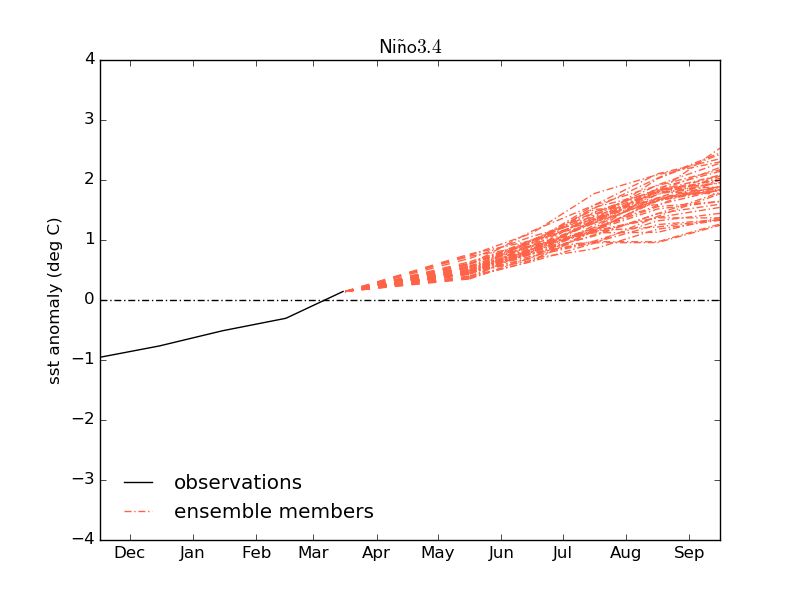
Figure 1: Met Office ENSO forecasts for the coming period showing rapid increase in Pacific Ocean temperature anomalies and the possibility of a large El Nino event (>2 degrees) this year. The observed data (black) and multiple ENSO forecasts (red) are plotted relative to normal conditions in the region (averaged over 1991-2020)
The last three winters have seen a run of three consecutive La Niña events. This run of events, though unusual, has earlier precedents in the historical climate record, for example in 1999, 2000 and 2001 but this has now come to an end. Instead, our latest long-range forecasts suggest that the tropical Pacific is about to transition into El Niño – the warm phase of ENSO.
The figure shows our very latest forecasts for the sea surface temperature anomaly in the equatorial Pacific Ocean. The forecasts all indicate a sharp rise from the current neutral state to El Niño conditions (+0.5°C anomaly) by Summer this year. While there is still considerable uncertainty in the magnitude of the event, some of these latest forecasts also suggest that a large El Niño event is possible, with sea surface temperatures in some forecasts reaching more than 2 degrees above normal by the Autumn.
What does this mean for climate worldwide?
Both historical observations and our physics-based computer models show that El Niño brings increased risk of drought to South-East Asia, India, North-Eastern Australia and parts of the Amazon and southern Africa and increased risk of cold conditions to northern Europe in winter. We will be looking carefully at these regions with our colleagues at other national meteorological services as El Niño develops and updated forecasts become available.
In addition to these regional impacts, ENSO also affects global temperatures and in the year following its northern hemisphere winter peak, El Niño tends to be followed by a rise in global average temperature. This is much smaller than the current level of global warming of around 1.2 degrees that we have now accrued due to climate change but it can make all the difference in terms of breaking new records.
Professor Adam Scaife, Head of Long-Range Forecasting at the Met Office said, “The current record for global temperature occurred in 2016 and it’s no coincidence that followed the last big El Niño. If we get a big El Niño at the end of this year then, we’re likely to break the record for global temperature in 2024.”
