As the UK continues to experience a week of higher-than-average temperatures, early April is currently delivering a spell of notably warm weather for many.
Temperatures are well above average, sunshine has been widespread, and for some areas this period has a distinctly late‑spring feel. However, this warmth is not set to last, with a significant change on the way later in the week.
Alongside the evolving UK forecast, there have also been notable weather developments elsewhere around the globe, including tropical cyclones in the Pacific.
A look back at Storm Dave
The recent rise in temperatures follows a much more unsettled start to the Easter period, when Storm Dave affected the UK. The storm developed to the south‑west of the country before pushing across northern and western areas, bringing strong and disruptive winds to parts of Northern Ireland, northern England and north Wales.
One of the most notable impacts was the strength of the winds, with a peak gust of 93 mph recorded at Capel Curig. This marked the windiest Easter Saturday on record at the site. While Easter falls on different dates each year, this was still an exceptionally strong storm for early April. Conditions gradually improved through the remainder of the weekend as pressure rose and winds eased, allowing more settled weather to develop.
Why is it so warm?
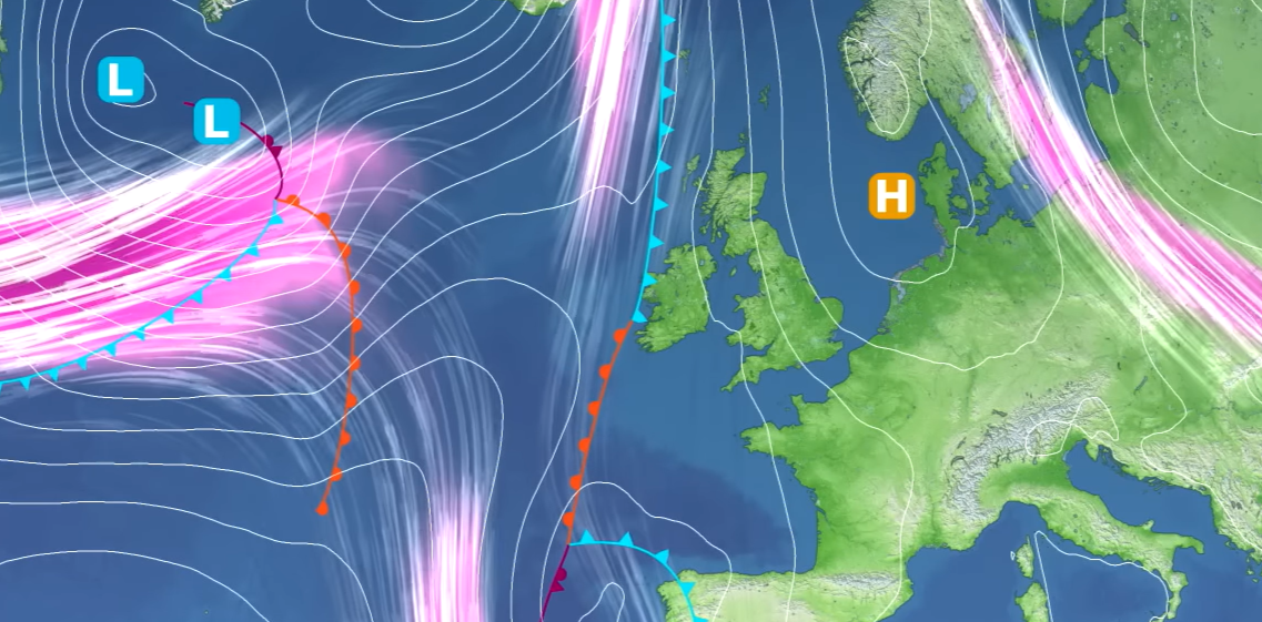
The current warm spell is being driven by a particular large‑scale weather pattern. Although the jet stream remains active across parts of the Atlantic, it has taken on an amplified shape closer to the UK. This has allowed low pressure to sit well to the south, bringing unsettled weather to parts of southern Europe and North Africa, while high pressure has become established further east across the continent.
Around this high pressure, winds have turned southerly, drawing much warmer air northwards towards the UK. At this time of year, land surfaces are warming quickly as days become longer, allowing temperatures to rise rapidly under sunshine. While sea temperatures remain low, daytime heating over land, combined with the arrival of warmer air from further south, has enabled temperatures to climb well above the seasonal norm.
This plume of warm air has been most influential through Tuesday and Wednesday and is responsible for the peak of the warmth experienced so far this year.
READ MORE: Fool’s spring: why warm spells can be misleading
Where the highest temperatures are occurring
The warmest conditions on Tuesday were focused across parts of western Britain, including north Devon and north Wales. In these areas, temperatures have been further enhanced by a föhn effect, where air descending on the lee side of hills warms and dries more rapidly. Similar effects can also occur along parts of the Moray coast in north‑east Scotland.
All four nations recorded their highest temperatures of the year so far:
- England 22.3°C at Merryfield
- Wales 24.8°C at Mona
- Northern Ireland 19.0°C at Armagh
- Scotland 20.5°C at Threave
By Wednesday, the focus of the highest temperatures shifts further east. As a cold front begins to approach from the north‑west, the very warm air is pushed across eastern and south‑eastern parts of England. This is where temperatures are most likely to peak, potentially reaching 26 or even 27°C in a few locations.
Such values are exceptionally high for this stage of April. Temperatures above the mid‑20s this early in the month are rare, and conditions like this have not been widely seen since the notably warm spring of 2020.
Is this a heatwave?
Despite the high temperatures, this spell does not meet the technical definition of a heatwave. Heatwave criteria require temperatures to exceed region‑specific thresholds for at least three consecutive days. These thresholds vary across the UK, typically ranging from around 24°C to 27°C depending on location.
While one or two days may reach or exceed these values in places, temperatures are not expected to remain widely above thresholds for long enough to qualify. That said, this is still a notable early‑season warm spell.
READ MORE: What is a heatwave?
A sharp change later in the week
The warmth will not last. A cold front pushing in from the north‑west will bring a marked change from Thursday onwards. Cooler air will spread south‑eastwards, accompanied by increased cloud, spells of rain and stronger winds at times.
In some western and north‑western parts of the UK, maximum temperatures on Thursday could be as much as 10°C lower than those recorded on Wednesday. This kind of rapid temperature swing is typical of spring, when contrasting air masses frequently compete for dominance.
While south‑eastern England is likely to hold on to warmer conditions for a little longer, even here temperatures will eventually fall back closer to average. Nights will also turn colder later in the week, with the potential for frost returning in some areas, particularly where skies clear. Gardeners should be mindful of this shift.
Into the weekend: cooler and more unsettled
By Friday into the weekend, attention turns to another area of low pressure moving in from the Atlantic. This system is being strengthened by a strong jet stream, driven by contrasts between cold air spilling south from Canada and much warmer air further south.
This low is expected to remain to the north‑west of the UK but will still bring more unsettled conditions, particularly to Northern Ireland, Scotland and western areas of Britain. Showers, spells of rain and brisk winds are likely, though it does not currently look comparable in strength to Storm Dave.
Further south and east, conditions may remain relatively drier at times, though still cooler than earlier in the week. Overall, the weekend looks changeable rather than a complete washout.
READ MORE: Week ahead: a week of two halves
Looking further ahead
Longer‑range indications suggest that while low pressure becomes more influential in the short term, high pressure is likely to stay relatively close to the UK overall. This means that conditions may remain mixed through the remainder of April, with alternating spells of settled and unsettled weather.
There is also potential for further warm spells later in the month as continental heat continues to build and sea temperatures gradually rise. However, spring remains a season of contrasts, and sudden changes are still likely.
Weather beyond the UK
Elsewhere in the world, there are some notable weather systems underway across the Pacific. A severe tropical cyclone, Myla, is affecting parts of the Solomon Islands and Papua New Guinea, bringing the risk of very heavy rainfall and flooding. This system is unusual both in its strength and its location, with tropical cyclones of this intensity uncommon so close to land in that region.
Another tropical cyclone, Viano, is tracking towards Fiji and is expected to weaken as it moves southwards into cooler waters, though it may still bring strong winds and heavy rain to parts of New Zealand later in the week. These systems highlight how global weather patterns remain active even as the UK enjoys a spell of spring warmth.
You can find the latest forecast on our website, on YouTube, by following us on X and Facebook, as well as on our mobile app which is available for iPhone from the App store and for Android from the Google Play store.