The week ahead brings a notable change in the weather pattern, with milder air at first replacing the cooler conditions of late March, before a more unsettled and blustery spell develops as we head towards the Easter period.
While there will be some drier and brighter interludes, particularly early on, cloud, outbreaks of rain and strengthening winds will become more influential as the week progresses.
Early week: milder but often cloudy
High pressure close to the south-west of the UK will initially help draw in air from the mid-Atlantic. This marks a shift away from the chilly north-westerly flow experienced over the weekend, introducing milder conditions for many. However, this Atlantic air mass also carries plenty of moisture, so cloud will be widespread during the first half of the week.
There will be occasional breaks in the cloud, particularly across eastern and north-eastern areas. Where these develop, temperatures could rise into the mid-teens, with values of 16 or 17°C possible, and an isolated 18°C not out of the question. Elsewhere, temperatures will more commonly reach 13 or 14°C, still a few degrees higher than recent days. Overall, it will feel noticeably less cold, even where skies remain overcast.
If you're not a fan of the cold, we may have some good news as it's set to turn warmer for a time this week 🌡️
— Met Office (@metoffice) March 30, 2026
Here are more details, and an early look at the bank holiday weather 👇 pic.twitter.com/C11HUgrMfF
Midweek change: rain, hill snow and cooler air
By Wednesday, conditions begin to turn more unsettled, especially across Scotland and Northern Ireland. Cloud will thicken, winds will strengthen and more persistent rain will move in, particularly affecting central and northern Scotland. Over higher ground, this rain will increasingly fall as snow, generally above around 400 to 500 metres.
Ahead of this weather front, it will remain relatively mild, though not quite as warm as earlier in the week, with temperatures more typically reaching 15 or 16°C in the south. As the front moves south-eastwards overnight, colder air will return from the north-west, bringing a marked change by Thursday.
Clearer skies in the north and west early on Thursday may allow a touch of frost to form in places. These clearer conditions will also bring the best chance of brighter weather, a contrast to the grey skies earlier in the week. Elsewhere, sunny spells will develop during the day, although cloud will gradually build again and a few showers may affect eastern coastal areas during the morning.
Temperatures will feel fresher, with highs of around 11 or 12°C in the south and nearer 7 or 8°C further north. Later in the afternoon and evening, another spell of wet weather will move into western Scotland and Northern Ireland, again bringing snow over the hills and mountains.
READ MORE: Easter weather extremes: the records behind a famously changeable weekend
Late week and Easter period: unsettled and windy
Looking further ahead, attention turns to developments across the Atlantic. A significant contrast between cold air to the west and milder air further east will help strengthen the jet stream and shift it further south. This will increase the likelihood of more active weather systems affecting the UK as the week draws to a close.
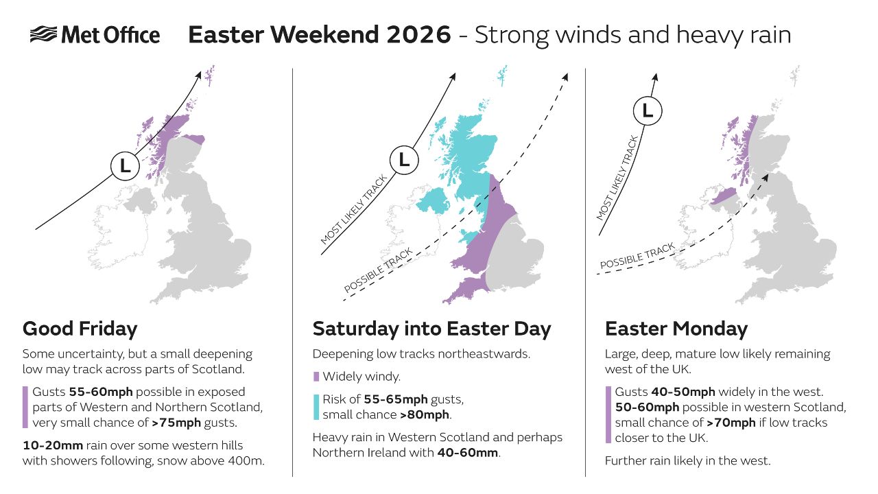
By Good Friday, low pressure is expected to be the dominant feature, most likely tracking close to northern Scotland. This will bring increasingly wet and windy conditions across much of the UK. While the south-east may stay dry for a time early on, spells of rain will spread across all areas during the day, with the heaviest and most persistent rain affecting the north and north-west.
Winds will strengthen markedly, with gales becoming increasingly likely across northern and western areas. The strongest gusts are most probable across the far north and north-west of Scotland, though the exact strength and location of peak winds will depend on the eventual track and depth of the low pressure system.
Bank holiday weekend weather
As we head into the rest of the Easter weekend, the unsettled theme looks set to continue. With the jet stream remaining active, further weather systems are likely to move in from the west. This means changeable conditions, with spells of rain or showers interspersed with drier, brighter intervals.
It will not rain all the time, and winds will not always be strong, but the overall pattern suggests a rather mixed and often blustery bank holiday weekend. Confidence in the finer detail remains lower at this range, particularly regarding the timing and intensity of individual weather systems, so forecasts will continue to be refined over the coming days.
 You can find the latest forecast on our website, on YouTube, by following us on X and Facebook, as well as on our mobile app which is available for iPhone from the App store and for Android from the Google Play store.