A significant shift is underway in the tropical Pacific, with clear signs that an El Niño event is developing.
El Niño is one of the most important drivers of year‑to‑year climate variability on Earth, influencing weather patterns across large parts of the globe as well as global temperature. While it occurs far from the UK, its impacts can be felt worldwide.
What is El Niño?
El Niño refers to a sustained period of warmer‑than‑average sea surface temperatures across the central and eastern equatorial Pacific Ocean. It forms part of a natural cycle known as the El Niño–Southern Oscillation, which alternates between warm (El Niño) and cool (La Niña) phases.
These events do not follow a fixed timetable. They can vary in strength and duration, and the gap between episodes is irregular. Each El Niño is unique, but stronger events tend to have more widespread and pronounced global effects.
Crossing important thresholds
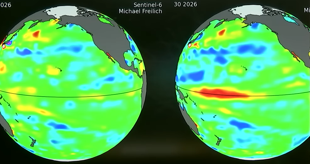
Sea surface temperatures across a key region of the central Pacific have been rising steadily in recent months. Observations show that temperatures have crossed important thresholds that are used internationally to identify El Niño conditions.
Satellite measurements also reveal that sea levels in this part of the Pacific are increasing. Warmer water expands, so rising sea level is another strong indicator that additional heat is building in the ocean. The pace and scale of these changes suggest a well‑established warming signal rather than a short‑lived fluctuation.
Forecasts based on multiple climate models point towards continued warming through the summer and to the end of the year. What stands out is how closely these forecasts agree with one another. When model projections cluster tightly together, it increases confidence that the overall direction of change is robust.
Grahame Madge, Senior press officer and climate science communicator at the Met Office said: “Other organisations around the world have other definitions and thresholds for what constitutes El Niño conditions, but this will be such a significant event, if it happens, that it will be above all of those thresholds and there will be no doubt that we’re in an El Niño.”
How strong could this event become?
Current projections suggest this El Niño could become a strong event, potentially comparable with some of the most impactful episodes in recent decades. El Niño events often peak towards the end of the year, with maximum influence typically felt between November and February.
There has been discussion in the media about a “super” El Niño. While that term is not officially recognised by the Met Office, there is growing confidence that this event could sit at the upper end of the historical range.
Grahame explained: “A ‘super’ El Niño is not a term we subscribe to, but it does underpin the fact that this is likely to be a significant event. Scientists are telling us that this could be the strongest El Niño event this so far century, comparable to the notable El Niño event in 1998.”
Global temperature implications
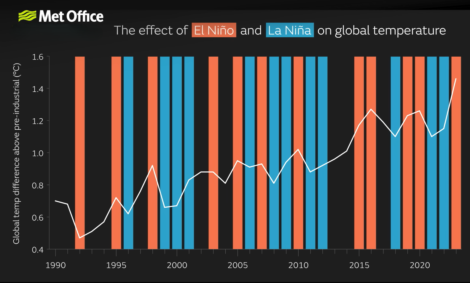
Historically, many of the warmest years on record have coincided with El Niño events. However, this warming effect sits on top of a longer‑term upward trend driven by human‑induced climate change. As a result, when a strong El Niño develops in today’s warmer climate, global temperatures can be pushed to particularly high levels.
Grahame continued: “An El Niño will impart heat into the atmosphere and, generally, raise global average temperatures by around a fifth of a degree Celsius. 1998 was a significant year for global temperature and, at the time, was the warmest year on record, with El Niño contributing to increased temperatures.”
Even cooler La Niña years in recent times have been warmer than strong El Niño years of the past, underlining how much the background climate has changed. Illustrating this point, the three most recent La Niña years are still quite a bit warmer than the powerful El Niño event in 1998.
Grahame said: “Almost 20 years later, background temperatures have continued to increase as a result of human-induced climate change. In 2023 we had the first year in which global temperatures were 1.4°C above pre-industrial levels, we’ve since had two more years in which we’ve hit those levels. With an El Niño it’s likely that next year will be a year above 1.5°C when compared with pre-industrial levels.”
Regional impacts around the world
El Niño reshapes rainfall and temperature patterns across the globe, though impacts vary by region and by season.
Areas close to the Pacific, such as parts of South America, can experience much wetter conditions, while regions including eastern Australia, Indonesia and parts of South‑East Asia often become drier and warmer than average. Reduced rainfall in these areas can increase drought risk and raise the likelihood of wildfires.
In parts of Africa, El Niño can shift rainfall patterns, bringing drier conditions to some regions and wetter conditions to others. India can also experience disruptions to the monsoon, which has significant implications for agriculture and water resources.
In North America, El Niño years are often associated with wetter conditions across parts of the southern United States, including California, while also influencing storm tracks further north.
Impacts on tropical storms
El Niño also affects tropical cyclone activity. In the Atlantic, El Niño tends to increase wind shear, which can suppress hurricane development. At the same time, the Pacific often becomes more favourable for powerful tropical storms as warmer ocean waters provide additional energy.
This contrast highlights how El Niño does not simply mean “more extreme weather everywhere”, but rather a shift in where and how weather hazards occur.
What does this mean for the UK?
El Niño takes place thousands of kilometres away from north‑west Europe, so its influence on UK weather is indirect. While there are sometimes links between El Niño events and European weather patterns, these are far from guaranteed.
The UK’s weather is shaped by many competing factors that affect the Atlantic jet stream and other large‑scale atmospheric patterns. As a result, it is too early to draw firm conclusions about what this developing El Niño might mean for future UK seasons.
Keep up to date with weather warnings, and you can find the latest forecast on our website, on YouTube, by following us on X and Facebook, as well as on our mobile app which is available for iPhone from the App store and for Android from the Google Play store.