
Data and observations are the lifeblood of meteorological organisations. But how is it changing and what’s the impact of new and upcoming projects?
The Met Office is a data-rich organisation, with observations and data coming from ocean buoys and aircraft to weather stations and radars, and plenty in between.
Satellite data is the largest contributor to numerical weather prediction accuracy. While the imagery from satellites can be vital for meteorologists, the data from satellites also informs ongoing complex calculations about the future state of the weather; providing an overview of dominant weather regimes that otherwise wouldn’t be possible without satellite technology.
In this blog, we explore some recent and upcoming satellite projects that are helping to transform the Met Office’s weather and climate intelligence.
Sentinel-6B - Monitoring the world's oceans
Successfully launched this week, Sentinel-6B is a satellite mission that is the focus for many ocean and climate monitoring experts.
Once operational, the satellite, which is the latest in the Copernicus programme on Earth observations, will chiefly monitor the world’s oceans. Data will be used to monitor sea level rise, significant wave height as well as wind speeds across the globe.
The data will be crucial for both long-term climate monitoring but will also be used in ocean forecasting models. This in turn will influence our weather forecasts due to the important influence the ocean has on the atmosphere.
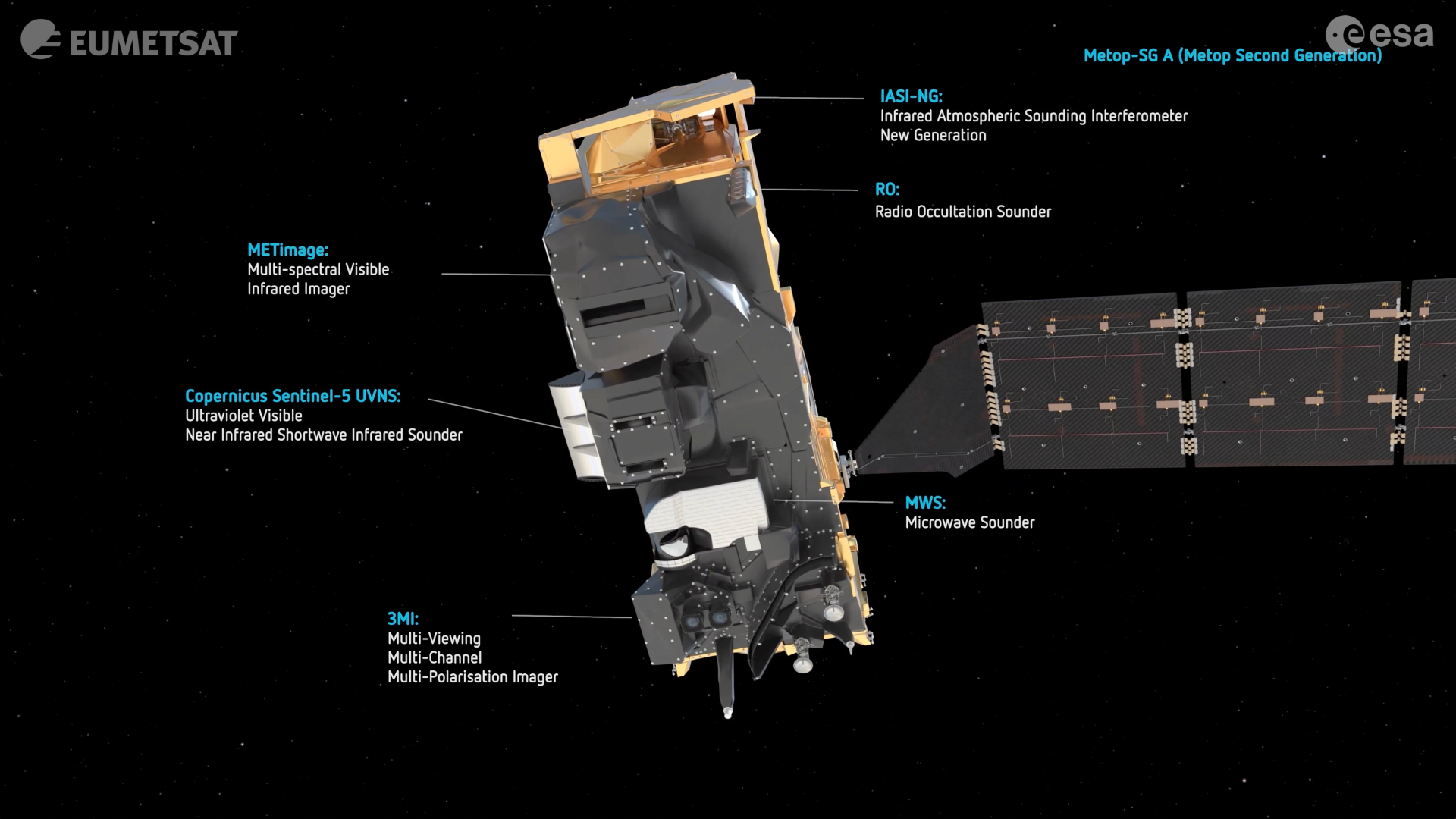
Metop-SG A1 - High resolution imagery at a global scale
Metop-SG A1 is the first of six polar-orbiting satellites launched as part of the Metop Second Generation series.
This satellite, which was launched in August 2025, carries six advanced instruments which allow measurements to be taken through the depth of the atmosphere to the surface. The satellite will provide a global view of the weather, completing one full orbit every 100 minutes. The finer resolution of data available will enable more complex calculations to be run as part of weather forecast models and should ultimately enhance forecast accuracy.
Preliminary data looks promising. The first operational data from the satellite will be available in mid-2026. A second satellite, MetopSG-B1, will carry a further 4 complementary instruments and is due for launch later in 2026.
Vigil - Space weather forecasting
Weather of a whole different variety is in focus for this mission: space weather.
The Met Office is one of a handful of 24/7 space weather forecasters in the world. The mission? Monitor the Sun for potentially impactful space weather events, including solar flares, coronal mass ejections and solar winds.
Space weather monitoring lags far behind that of conventional meteorology, with just a handful of observations and satellites informing forecasts.
The Vigil mission, which is hoped to launch in the 2030s, will provide a side-on view of the Sun from around 150 million kilometres away in what will be a major leap forward for space weather monitoring. This should vastly enhance forecasting capability for severe space weather events, which have the potential to disrupt
MTG-I1 (Meteosat-12) - The power of nowcasting
Meteosat’s Third Generation Imager (MTG-I1) launched in 2022 and is now in operational use in weather forecasting.
The satellite, which is now referred to as Meteosat-12, is positioned in geostationary orbit 36,000km above Earth and provides a constant view of Europe and Africa. Imagery from the satellite chiefly focuses on improvements on short-range ‘nowcasting’ of severe convective systems and includes more detailed and frequent imagery for use by meteorologists and in complex weather forecasting calculations. A new lightning imager gives us measurements of lightning from space for the first time over this region– another tool in forecasting rapidly developing storms.
MTG-S1 - 3D data fit for the future
This geostationary satellite launched in July and, once fully operational, will be the first ever European sounding satellite in geostationary orbit. It will complement the Meteosat-12 imager satellite, and will provide regular information on the profiles of temperature and humidity through the atmosphere. This will allow more frequent and complex 3D data to be used in supercomputer calculations, further improving forecast accuracy in the coming years.
Information from the instruments on board should also improve our knowledge of where severe storms may form in the coming hours, and the location of hazardous volcanic ash and airborne pollutants, improving our early warning of life-threatening atmospheric conditions.
Satellite data is just one way that the Met Office’s weather and climate intelligence is being enhanced. Robust, reliable data is of paramount importance for weather forecasts and climate monitoring and, coupled with Met Office expertise, improvements to data sources will be vital for the next generation of weather and climate monitoring and forecasting.
Find out more about how the power of weather and climate intelligence means we can empower the public, government and industry to make smarter decisions with serious impact.