This week’s weather discussion is dominated by the extraordinary development of Hurricane Melissa, a system that has rapidly intensified and is now making headlines across the Atlantic.
As we approach the end of October, with half-term and Halloween on the horizon, the weather is set to play a significant role in our plans.
In this deep dive, we will explore the evolution of Hurricane Melissa, its impacts across the Caribbean, and what it could mean for the UK in the days ahead.
Hurricane Melissa: Formation and intensification
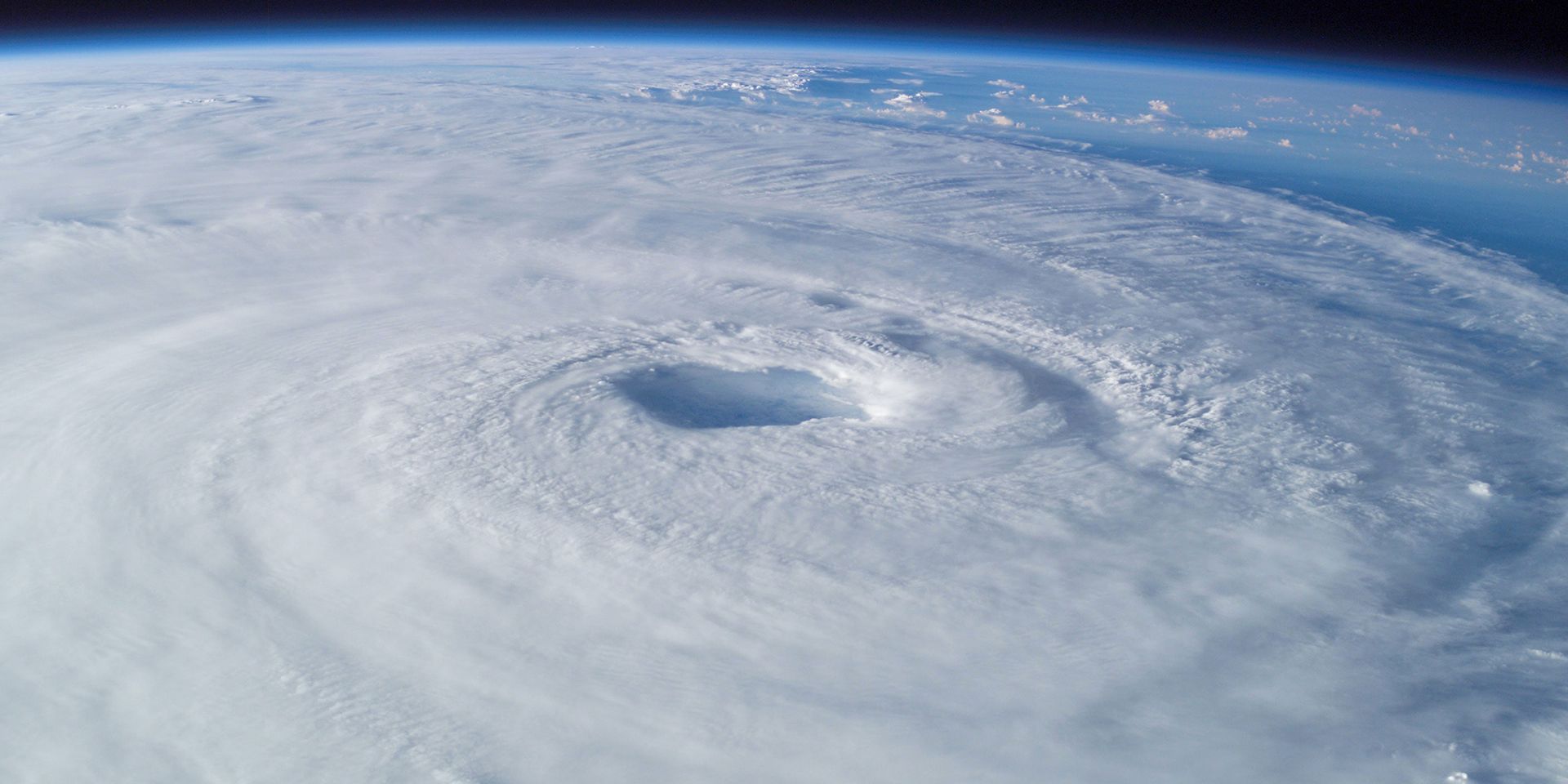
Hurricane Melissa has become a defining feature of this week’s meteorological landscape. Over the weekend, the system intensified into a category 5 hurricane, with sustained wind speeds reaching around 185 mph, well above the 157mph threshold required for category 5 status.
#Melissa makes landfall in southwestern Jamaica near New Hope as a powerful category 5 hurricane. For the latest updates visit https://t.co/tW4KeGdBFb pic.twitter.com/4zkLYat3g4
— National Hurricane Center (@NHC_Atlantic) October 28, 2025
This rapid intensification has been driven by a combination of very warm sea surface temperatures, light steering winds, and a favourable atmospheric setup, all of which have allowed the storm to gather strength and maintain its intensity.
Rainfall and impacts
The impacts of Hurricane Melissa have been severe. Forecasts indicate that the storm could bring up to 1,000 millimetres of rain over its lifespan, with Jamaica, Cuba, Haiti, and other parts of the Caribbean facing the brunt of the deluge. Such rainfall totals are comparable to what London typically receives in an entire year but compressed into just a few days.
The combination of intense rainfall, strong winds, and storm surges has led to widespread flooding, landslides, and significant infrastructure damage. Tragically, there have already been reports of fatalities, and the situation remains dynamic as the storm continues its journey northwards.
Historical context
Melissa’s intensity is notable not just for this season, but in the context of Atlantic hurricane history. It is the third category 5 hurricane of the current season, following Erin and Humberto. The last time the Atlantic saw three category 5 hurricanes in a single season was in 2005, a year that remains etched in memory for its extraordinary tropical activity.
For Jamaica, Melissa is the most powerful hurricane to make landfall since Hurricane Gilbert in 1988, which was a category 3 storm. The central pressure of Melissa dropped to 892 millibars, making it the sixth lowest pressure ever recorded for a North Atlantic hurricane, surpassing even Hurricane Katrina.
Why has Melissa been so powerful?
The exceptional strength of Hurricane Melissa can be attributed to several key meteorological factors. First, the sea surface temperatures in the Caribbean have been particularly warm, ranging from 29 to 30°C, several degrees above average for this time of year. Warm waters provide the energy hurricanes need to intensify, and in this case, the warmth extends well below the surface, offering a continuous fuel source even as the storm upwells deeper water.
READ MORE: Hurricanes, typhoons and tornadoes: What’s the difference?
Second, the storm’s track has been unusual. Rather than following the typical east-southeast to west-northwest path, Melissa has pushed up from the south, encountering light steering winds that have allowed it to linger and intensify over the same region. This slow movement has exacerbated the impacts, with prolonged periods of heavy rain and strong winds affecting the same areas.
Third, the atmospheric setup has provided just the right amount of wind shear, enough to help organise the storm, but not so much as to disrupt its structure. The geography of Jamaica, with its areas of high ground, has also contributed to intense rainfall and the risk of landslides, while low-lying coastal regions have faced the threat of storm surges and flooding.
Climate change context
It is worth noting that the conditions fuelling Melissa’s development, particularly the above-average sea surface temperatures, are consistent with the broader trends associated with climate change.
As global temperatures rise, the oceans are absorbing more heat, creating an environment that is increasingly conducive to the formation of intense tropical cyclones. While it is not possible to attribute any single storm directly to climate change, the frequency and severity of such events are expected to increase in a warming world.
The forecast track: Will Melissa affect the UK?
As Hurricane Melissa continues to move north-north-eastwards through the Caribbean, attention turns to its potential path across the Atlantic. Forecast models suggest that the storm will eventually encounter cooler waters and drier air, which should lead to its weakening. However, there remains some uncertainty about its exact track, with some models indicating a possible approach towards the UK or even Iceland.
#Melissa makes landfall in southwestern Jamaica near New Hope as a powerful category 5 hurricane. For the latest updates visit https://t.co/tW4KeGdBFb pic.twitter.com/4zkLYat3g4
— National Hurricane Center (@NHC_Atlantic) October 28, 2025
It is important to note that hurricanes do not typically reach the UK in their tropical form. Instead, as they cross the Atlantic, they transition into extratropical systems, sometimes referred to as “ex-hurricanes”, which can still bring wet and windy weather, but without the extreme winds and rainfall associated with their earlier stages. For Melissa, the current outlook suggests that while it may bring some unsettled conditions to the UK, it will not be as catastrophic as it has been for the Caribbean.
READ MORE: When is a hurricane not a hurricane?
The Met Office’s global model, along with other international models, continues to monitor the storm’s progress. There is a possibility that Melissa could bring some wet and windy weather to parts of the UK, particularly in the northwest, but the most severe impacts are expected to remain well to the south and west. As always, the situation will be closely monitored, and forecasts will be updated as new data becomes available.
The UK outlook: Changeable weather ahead
While the focus has been on Hurricane Melissa, there is also the potential for another area of low pressure to develop and affect the UK later in the week. This system, separate from Melissa, could bring strong winds and outbreaks of rain, particularly to western areas.
The Met Office, in collaboration with Met Éireann and KNMI in the Netherlands, is monitoring the situation to determine whether the system meets the criteria for a named storm. At present, it does not appear likely, but the situation could change with new model runs.
Halloween and half-term weather
With Halloween approaching and many people out and about for half-term, the weather is set to be unsettled. Thursday and Friday could see periods of wet and windy weather, especially in the south and west.
While the strongest winds are expected to affect Ireland and Northern Ireland, the UK will not be immune to breezy conditions and showers. Those planning to go trick-or-treating should be prepared for changeable weather, with the possibility of rain and gusty winds in some areas.
Longer-term patterns
Looking further ahead, the weather pattern remains highly changeable. The jet stream is currently very active and wavy, which means that areas of low pressure are likely to continue moving across the UK, bringing alternating spells of wet and dry weather.
There are no clear signals at this stage for a prolonged period of high pressure, cold, or mild conditions. Instead, the outlook is for a typical autumnal mix, with the weather “up and down” over the coming weeks.
October rainfall: A dry month overall
Despite the recent spells of showery weather, October has been a relatively dry month for many parts of the UK. Rainfall totals remain below average in most regions, with only the northwest seeing amounts close to the seasonal norm. This means that, while the prospect of more rain may not be welcome for everyone, it is needed in some areas to replenish soil moisture and water supplies.
READ MORE: Typhoons: What are they and how do they form?
The full statistics for October will be available next week, providing a clearer picture of how the month has compared to the long-term average.
In summary, this week’s deep dive has highlighted the extraordinary development of Hurricane Melissa, a storm that has set new records and brought significant impacts to the Caribbean. While the UK is unlikely to experience the full force of Melissa, the weather remains unsettled, with the potential for wet and windy conditions as we move into November. The Met Office will continue to monitor the situation closely, providing updates and guidance as needed.
As always, it is important to stay informed by checking the latest forecasts, especially if you have plans for half-term or Halloween. The weather may be changeable, but with the right information, you can be prepared for whatever comes your way.
Keep up to date with weather warnings, and you can find the latest forecast on our website, on YouTube, by following us on X and Facebook, as well as on our mobile app which is available for iPhone from the App store and for Android from the Google Play store.