
As we move through May, Spring 2025 is shaping up to be a contender for the record books, particularly when it comes to temperature, rainfall, and sunshine. With data up to May 13, the UK is experiencing a season marked by warmth, dryness, and bright skies, all of which raise the question: how close are we to breaking spring weather records?
March saw a record-breaking month for sunshine, with temperatures above average and rainfall well below. April 2025 was the sunniest April on record for the UK and again, temperatures were above average and rainfall well below almost everywhere. So how is May looking so far?
What are the stats saying?
So far, the mean temperature for the UK this spring stands at 8.77°C, which is 0.69°C above the seasonal average. This places it as the 8th warmest spring since the series began in 1884. While it’s not yet at the top, it’s worth noting that at present, eight of the 10 warmest springs have occurred since the year 2000.
The current record for the warmest spring is 9.37°C, set just last year in 2024. And again, although we have more than two weeks to go, the consistency of above-average temperatures could be significant.
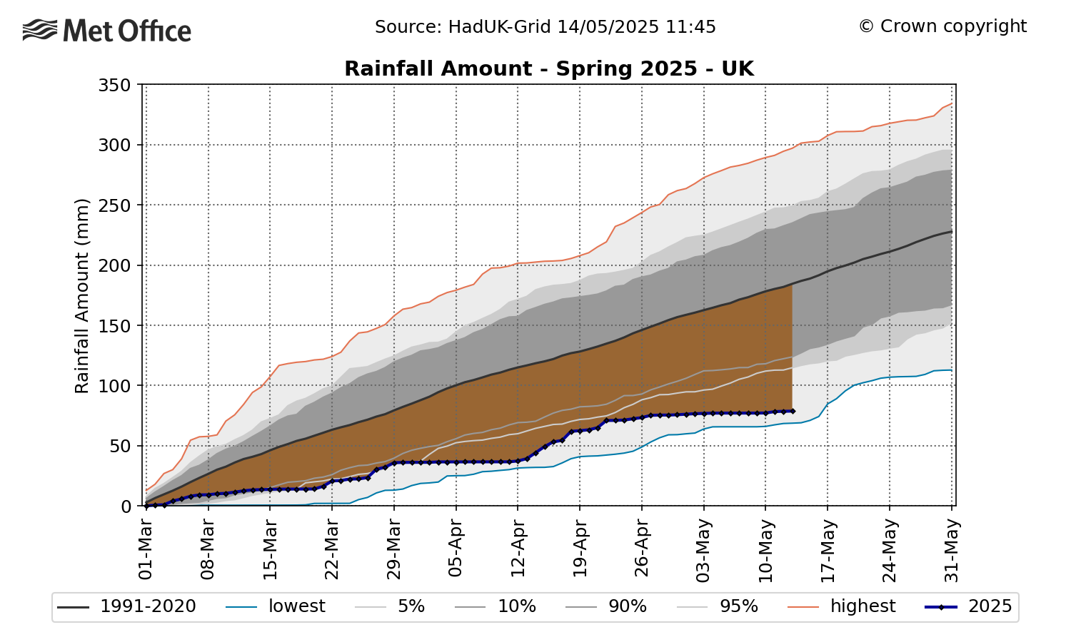
Perhaps the most striking statistic is rainfall, or lack thereof. With just 80.6mm recorded so far for the UK, Spring 2025 is, so far, currently ranking at the driest spring in over a century. The previous record low for the full season was 100.7mm, set in 1852. With a couple of weeks of May left though, it’s still too early to say how the month and spring as a whole will rank.
The below graph shows the rainfall amount so far this spring, compared to the 1991-2020 long-term averaging period.
Sunshine hours are also climbing. The UK has already seen 507.0 hours of sunshine this spring. The current record, set in 2020, is 626 hours. England currently ranks as the 5th sunniest spring on record, while the UK stands in 8th place. If our recent dry and clear conditions continue, these rankings could still rise.
What’s behind the weather?
The dominant factor behind this unusual spring is the persistent high-pressure systems, often originating from the Azores or mainland Europe. These systems have lingered over the UK since late February, blocking the usual flow of Atlantic weather fronts. The jet stream, which typically guides these systems, has taken a more northerly path, allowing high pressure to dominate.
What is the forecast for the next week?
The forecast for the next week or so remains largely dry, with perhaps just a little drizzle or an isolated shower. Heading into the Bank Holiday Weekend, things get a bit more interesting with indications of some wetter and windier weather, particularly in western regions although temperatures are expected to stay near or slightly above average.