Weather radar is one of the most powerful tools in the Met Office’s arsenal for observing and forecasting the UK’s ever-changing weather.
From tracking rain and snow to supporting flood warnings and aviation safety, radar technology underpins much of the real-time information that helps keep communities safe and informed.
By combining advanced technology with expert analysis, radar helps deliver the information that communities, businesses, and decision-makers rely on every day.
The science behind radar technology
Radar operates by emitting electromagnetic beams that travel through the atmosphere. When these beams encounter small particles, such as raindrops, they are reflected back to the radar receiver. By analysing these reflections, meteorologists can determine the location, intensity, and movement of precipitation. This process allows for real-time mapping of rainfall, snow and storm systems, providing essential data for short-term forecasting and severe weather warnings.
Integrating radar into the observation network
The Met Office collects data from a network of radar stations strategically positioned across the UK. These stations work in concert with other observation systems, including satellites, weather stations, and aircraft-based sensors. The integration of radar data with other sources creates a comprehensive view of atmospheric conditions, supporting both immediate responses and longer-term forecasting.
READ MORE: Observations: The foundation of accurate weather forecasting
Radar’s high-resolution data is especially valuable for “nowcasting”, the prediction of weather over the next few hours. By tracking the development and movement of rain showers and storms, forecasters can issue timely alerts for heavy rainfall, thunderstorms, and potential flooding. This capability is vital for public safety, transport operations, and event planning.
A closer look: flying ants and radar signatures
One of the more unusual observations picked up on radar came not from the skies, but from the ground, or rather, just above it. Back in July, swarms of flying ants were picked up on radar, appearing as strange, flashing echoes to the northwest of London. These were initially mistaken for showers, but closer inspection revealed their true identity.
Flying ants, being similar in size to raindrops, can also reflect the electromagnetic beams emitted by radar, creating signatures that resemble precipitation. This phenomenon, often seen during “Flying Ant Day,” is a fascinating example of how biological activity can intersect with meteorological technology.
Supporting forecasts and public services
Radar data is a critical input for the Met Office’s forecasting models. It enables meteorologists to monitor weather systems as they evolve, refine predictions, and provide accurate information to the public. The infrastructure supporting radar observations is continuously maintained and upgraded, ensuring that the data remains reliable and relevant.
READ MORE: Rain or showers? What's the difference?
In addition to supporting daily forecasts, radar plays a key role when it comes to issuing severe weather warnings. By detecting the onset and progression of heavy rainfall or storms, the Met Office can alert emergency services, local authorities, and the public, helping to mitigate risks and protect lives and property.
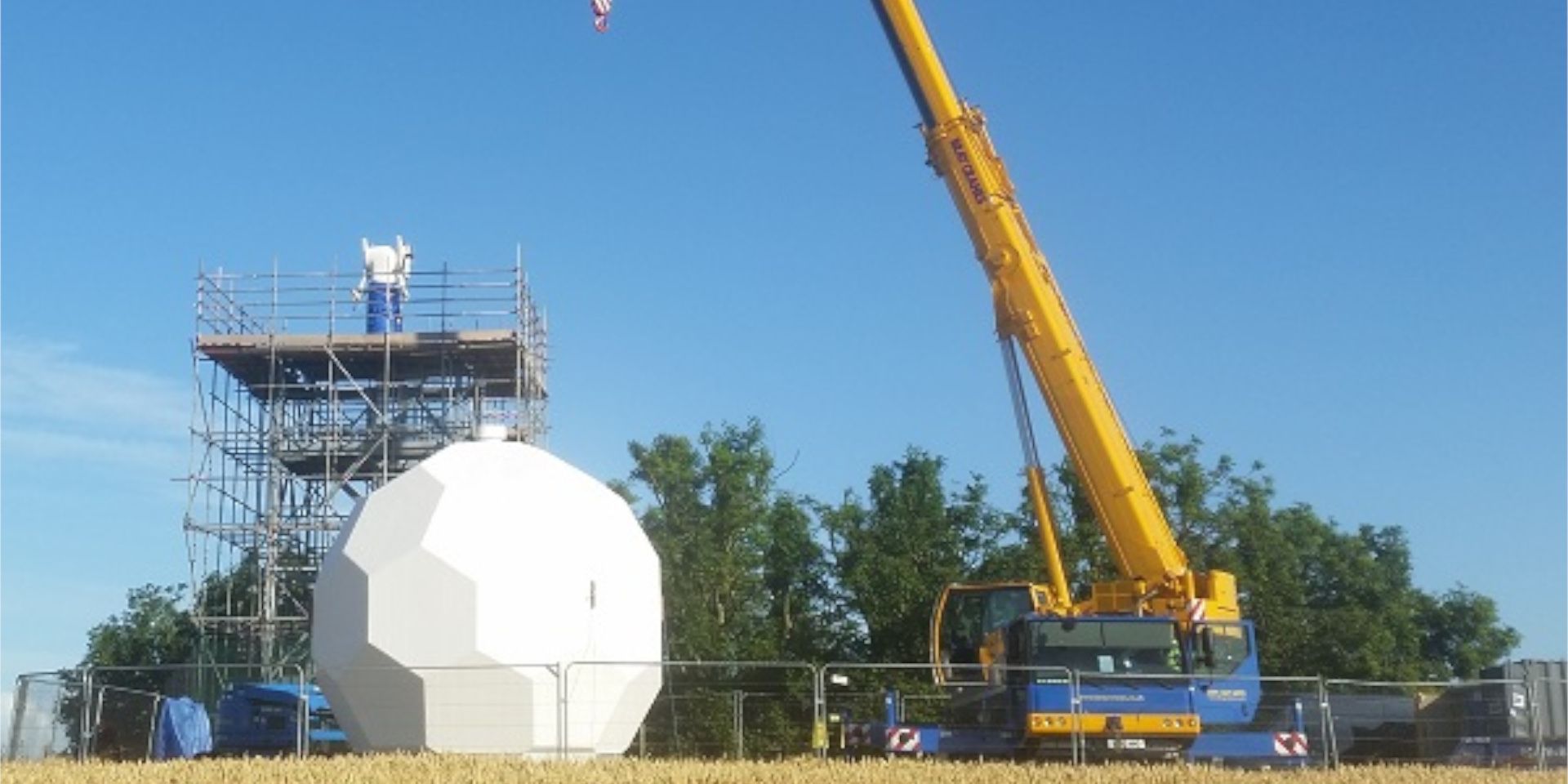
Investing in the future: the East Anglian radar project
Recognising the need for improved coverage in East Anglia, the Met Office and the Environment Agency have jointly funded the construction of a new radar in Norfolk. This is the UK’s first new weather radar installation since 2009 and will provide high-resolution rainfall data for a region that has historically lacked the coverage seen elsewhere in England.
The new radar will be particularly valuable for emergency response during extreme weather, such as rapidly developing heavy showers and easterly snowfall. It will also support water resource management in partnership with Anglian Water and the Environment Agency. The project team conducted a thorough investigation into possible sites, weighing benefits against costs and risks, and identified a site in Old Buckenham as the only one capable of providing 1 km resolution coverage over the whole of Norfolk.
READ MORE: East Anglian radar project
Construction is now underway, with the radar expected to be fully operational by early summer 2026. The improved coverage will help meteorologists deal more confidently with easterly and north-easterly snow situations, summer convective storms, and slow-moving weather systems. It is estimated that the damage avoided by the introduction of the radar and the resulting improvement to severe weather and flood warnings could amount to over £1 million per annum.
Innovation and continuous improvement
The Met Office is committed to advancing radar technology and its applications. Ongoing research and development focuses on enhancing the sensitivity and resolution of radar systems, as well as improving data processing techniques. Collaboration with universities, research institutions, and both national and international partners further strengthens the infrastructure behind radar observations. By sharing expertise and resources, the Met Office contributes to global advancements in meteorological science.
Radar is an indispensable part of the Met Office’s observation and forecasting infrastructure. Its ability to detect precipitation, track weather systems, and even register biological phenomena like flying ants highlights the sophistication and versatility of the technology.
Keep up to date with weather warnings, and you can find the latest forecast on our website, on YouTube, by following us on X and Facebook, as well as on our mobile app which is available for iPhone from the App store and for Android from the Google Play store.