The Met Office has achieved significant improvements in maritime forecast accuracy over the past 10 years, benefitting safety and economic performance.
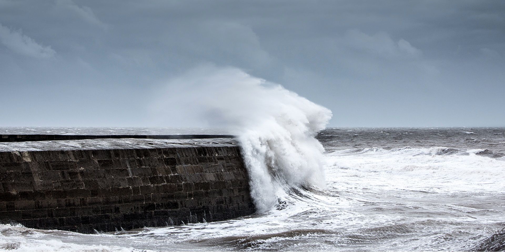
From marine officer pilots determining if a ship can depart port or managing offshore wind farm projects, to cargo ship captains navigating rough seas – safety, efficiency and sustainability at sea rely on accurate weather forecasts.
This critical information affects more than operational efficiency and economic benefits; it helps people at sea stay safe and thrive. Research suggests that 30% of marine accidents are caused by poor weather conditions, making accurate forecasting a critical factor when it comes to making decisions at sea.
Significant improvements over 10 years
New analysis shows that the Met Office’s Shipping Forecast accuracy has steadily improved over the past decade. Wind direction consistently shows the highest proportion of exactly correct forecasts, maintaining its position as the most accurate of the three metrics. Wind speed forecasts have also become more reliable, with a clear upward trend in precision, despite occasional fluctuations. Sea state predictions, while more variable, have similarly shown gains in accuracy over time (see figure 1). In detail, wind speed accuracy rose from 72% to 82%, wind direction from 82% to 88%, and sea state from 64% to 75% (see figure 2).
Forecasts continue to be more accurate in some sea areas than others. During the most recent 12-month period, the wind speed component - arguably the most important aspect of the Shipping Forecast - ranged from 71% correct in Irish Sea to 89% correct in Sole. The wind direction component ranged from 84% correct in Tyne to 94% correct in Fitzroy.
This continuous near-real-time monitoring, reporting and discussion helps our operational meteorologists identify and devise procedures to correct any adverse performance trends.
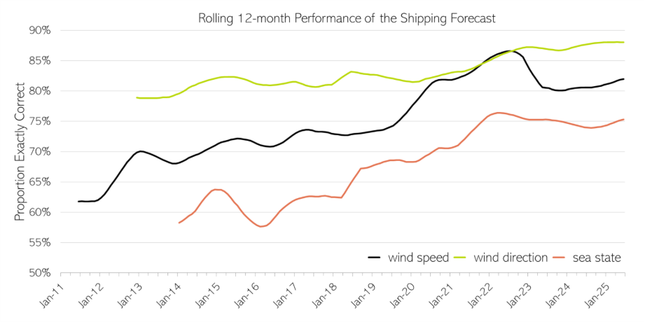
Figure 1: Graphic illustrates the rolling 12-month performance of the UK Shipping Forecast across three key metrics: wind direction, wind speed, and sea state. The data spans from January 2011 to January 2025. Wind direction (lime green line) consistently shows the highest proportion of exactly correct predictions. Both wind speed (black line) and sea state (orange line) show a steady upward trend, indicating consistent improvements in accuracy. Overall, the chart highlights a clear trajectory of enhanced forecasting performance across all categories.
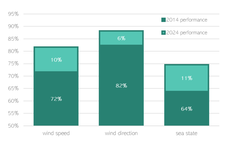
Figure 2: Bar chart illustrating the progress made in Shipping Forecast accuracy for wind speed, wind direction, and sea state. Comparing the performances during 2014 and 2024, the chart shows significant improvements: Wind speed accuracy rose from 72% to 82%, wind direction from 82% to 88%, and sea state from 64% to 75%.
Global verification standards
The Met Office rigorously interprets and verifies the hand-written text within each Shipping Forecast, assessing it for accuracy within each named sea area. We read the actual text written by hand by the forecaster, interpret it within each of the sea areas, and produce verification statistics for the customer.
This comprehensive approach goes beyond simply providing forecasts. It continuously proves their effectiveness through sophisticated verification technology.
The UK is responsible for coordinating forecasts across METAREA I, which largely covers the NE Atlantic Ocean and North Sea. However, the Met Office’s verification system can just as easily be applied to any global maritime region.
Why does this advancement matter exactly?
The Shipping Forecast remains an essential daily tool for maritime professionals making critical safety and operational decisions at sea.
“The Shipping Forecast is very much a traditional style forecast, but I have to say it’s one that we still very much use...every morning I review the latest forecast,” says Captain Lewis MacKenzie, Master of the MV Isle of Lewis.
Every percentage point improvement in forecast accuracy translates to better-informed decisions at sea. When mariners have confidence in forecasts, they can operate safely when conditions permit, while avoiding genuinely dangerous weather.
“The advancements in forecasting weather and sea states have allowed fishers to reduce the risks they face, contributing to the improvements in safety we have seen over the years,” according to David Fenner, Head of Fishing Safety, Maritime and Coastguard Agency.
This improved accuracy supports the UK's vital maritime economy, enabling everything from commercial shipping to offshore energy operations, to make more informed decisions about when and how to operate safely.
“As a fisherman we have serious respect for the power of the sea. That respect for the sea is aided by the quality of weather forecasting we receive from the Met Office. When the quality of service strives to be better, it gives every maritime sector the confidence to make better, safer, well-informed decisions”, explains Derek Cardno, Marine Safety and Training Policy Manager, Scottish Fishermen’s Federation.
That's why new data showing significant improvements in Met Office maritime forecast accuracy over the past 10 years represents far more than a technical achievement. These improvements enable better decisions that keep people safe and support economic growth.
Building on the past
Shipping Forecast accuracy has improved significantly since its inception, driven by the need to reduce the high mortality rate among mariners. A major storm in 1859 led to the loss of hundreds of lives and prompted calls for a national warning system. Robert FitzRoy, founder of the Met Office, responded with early forecasts delivered via telegraph and coastal signals. Today, the Shipping Forecast is part of a global maritime safety network, with the UK responsible for METAREA I, and includes services like the Inshore Waters Forecast to support smaller vessels near the coast.
The science behind the Shipping Forecast’s accuracy
The Met Office monitors the accuracy of the Shipping Forecast by comparing forecast terms with both direct observations, where available, and high-resolution model analysis data reflecting past conditions.
These improvements are the result of sustained effort across multiple departments over many years. Advances in numerical weather prediction modelling feed through to operational meteorologists, who produce increasingly accurate forecast text. Meanwhile, the Shipping Forecast Performance verification system provides near real-time output that helps the marine forecasting bench continuously improve the Shipping Forecast accuracy by correcting any errors and refining future forecasts.
Looking to the future
The Met Office has developed a new automated first-draft Shipping Forecast production system. This prototype, run in real time, produces complete Shipping Forecast text that trials have shown to be as accurate as text produced by Met Office Operational Meteorologists. Currently, they begin writing Shipping Forecast text by adapting the previously issued forecast, which is always six hours out of date. The first-draft system generates text directly from model data, giving the forecasters more time to add and refine details, ultimately leading to a more comprehensive and accurate final product.
"This innovation represents the best of both worlds," explains Michael Sharpe. Operational Verification Scientist at the Met Office. "We're combining the latest probabilistic data from the Met Office's post-processed model with automated text generation, while preserving the human expertise that mariners depend on for critical decision-making.”
“The system represents an optimal blend of technological advancement and professional judgement, with potential for further AI enhancement to make the automated text even more closely matched to traditional Shipping Forecast style.”
This development exemplifies the Met Office's strategic commitment to blending physics, computer modelling and AI to improve accuracy and consistency while meeting customer needs.
___
The Shipping Forecast is produced by the Met Office on behalf of the Maritime and Coastguard Agency (MCA) as part of the UK's statutory obligations to provide Maritime Safety Information to seafarers via approved broadcasting methods. The Shipping Forecast is also shared with the BBC for its own broadcast.