After a notably wet start to September, the large‑scale pattern across the northern hemisphere is finally on the move.
That shift matters: it will change the flavour of the UK’s weather from quick‑fire Atlantic lows to slower, more meandering systems, bringing spells of heavy rain in places, warm interludes in the southeast, then a cooler, drier turn for many later next week.
In this Deep Dive, we unpack what has happened so far, what’s driving the change, and what to watch over the coming days.
A soggy start to September
Through the first two weeks of the month, rainfall has been widely above what you’d typically expect by mid‑September. The usual “halfway point” benchmark, about 50% of the month’s total, has already been exceeded in parts of South Wales, southern England, northwest England and Northern Ireland, with fewer areas sitting near average. Put simply, many places have had a soggy first half, particularly toward the south and west.
It's a mixed week of weather ahead, here's the latest 👇 pic.twitter.com/LPCiHSusXm
— Met Office (@metoffice) September 14, 2025
Even so, this wet spell is chipping away at a bigger, year‑to‑date deficit rather than erasing it outright. UK‑wide cumulative rainfall has trailed the long‑term average for much of 2025, leaving a “gap” that recent downpours have only partly closed.
Regionally, every area is still running a deficit when the year is taken as a whole, even South West England and South Wales, despite their wet September so far. There, the recent steep uptick in rainfall has removed roughly half of the shortfall, but several further weeks of comparable rain would be needed to fully catch up.
Northern Scotland is a good example of why context matters: it’s one of the UK’s rainiest regions in an average year, yet it too remains in deficit in 2025. Volumes that might seem “modest” for northern Scotland, around 700 mm accumulated so far, would be close to record‑breaking if transposed to parts of eastern England. Meanwhile, the east and northeast of England retain the most significant shortfalls, with little of that “deficit nibbling” evident so far this month.
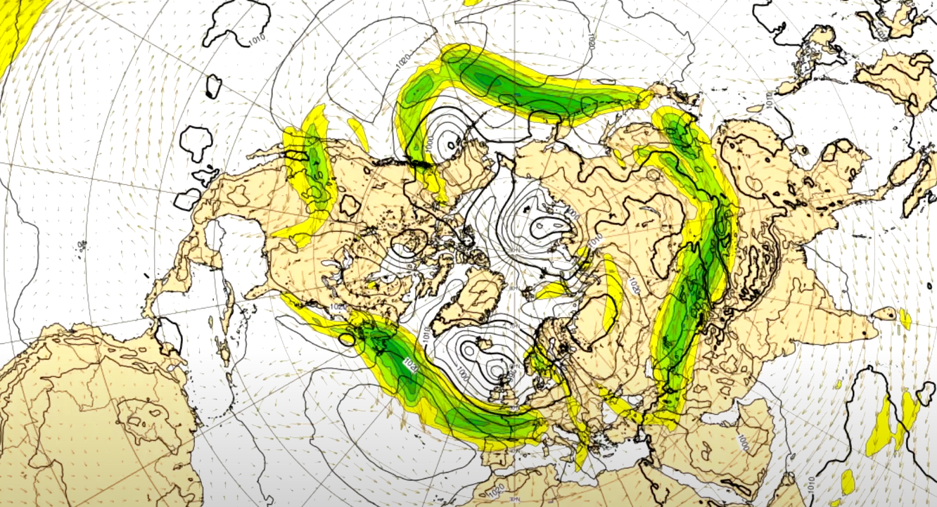
The jet stream set‑up: From motorway to meandering river
So, why the wet start? A flat, strong Atlantic Jetstream has behaved like a conveyor belt. Imagine a motorway, picking up low after low, deepening them and driving them straight towards the UK. It’s a classic early‑autumn pattern: the temperature contrast between the pole and subtropics powers the jet, while Earth’s topography, including the Rockies and Himalayas, helps impose broad ridges and troughs in the flow. In recent days the northern hemisphere pattern resembled a “wave number three” configuration, three broad ridge–trough couplets, which tend to be relatively stationary.
READ MORE: What is the jet stream and how does it affect our weather?
But a new disturbance is cracking the whip. A deepening low on the eastern side of the Pacific has tugged the jet stream to the south, injecting an extra ripple into the whole hemispheric wave train. That pushes us towards a “wave number four” evolution, which frees those ridges and troughs to start marching around the hemisphere rather than staying parked. For the UK, that means the long‑lived Atlantic trough that fed repeated lows is giving way to a more progressive pattern: first a slow‑moving trough over us, then a ridge building in. The snag? Part of the old trough is likely to pinch off into a cut‑off upper low over the near continent, an unpredictable “wanderer” that will keep the forecast complex.
A useful mental model is to swap the motorway for a meandering river. Instead of weather systems zipping along a straight, fast track, they bend and loop. Lows (and, later, highs) move more slowly, so any spell, wet or dry, lasts longer. That’s the defining change as we move into the second half of September.
The next few days: a slow‑moving trough and a stubborn front
In the near term, another Atlantic low brings a spell of rain and strengthening winds, with the heaviest totals focused on parts of Wales, enough for some localised impacts. This is the reasoning behind the yellow weather warning for southeastern Wales currently in place until 11pm Wednesday evening.
As that low edges north, it leaves behind a trailing frontal zone that becomes the key player into Thursday and Friday. With the jet increasingly aligned along the front, the band will “wriggle” rather than sweep through cleanly, wavering between North Wales, northern England and southern Scotland. Within that zone, bursts of heavy rain are likely, while areas just to the south will see drier, brighter and increasingly warm conditions.
READ MORE: What are weather fronts?
By Friday, the flow turns more southerly over the southeast. If cloud breaks sufficiently, temperatures could lift into the mid‑20s, 25 to 27°C is on the table for East Anglia and the southeast, while the far north will stay fresher and showery.
The weekend: A cut‑off low complicates the picture
Through the weekend, the upper trough pinches, and the resultant ‘cut‑off low’ drifts close to or across England and Wales. Cut‑offs are forecasting nuisances because they’re detached from the main jet, no longer carried cleanly along, so they can loiter and wobble, changing the location of the heaviest rain by modest but important distances. Under and near that low, bands of rain and showers may turn heavy and even thundery at times, especially in central and southern Britain.
Further north, high pressure nudges in from the Atlantic. Scotland and Northern Ireland are favoured for the brighter, drier conditions on Sunday, with just isolated showers and plenty of sunshine. As pressure builds to the north, a cooler northeasterly breeze begins to establish across the UK, marking a step down in temperatures from any Friday warmth in the southeast.
Next week: Ridge building, but there’s a fly in the ointment
The broader signal for next week is for a ridge to muscle into the UK from the west, promoting drier and more settled weather for many. If the cut‑off low were absent, this would be a straightforward fine spell. Instead, that “fly in the ointment” could linger near southern Britain early in the week, delivering further heavy rain in southern counties of England (and perhaps South Wales) before slipping into the near continent. The rest of the UK looks drier, albeit not necessarily warm, with a relatively cool northeasterly keeping temperatures on the modest side for a time.
READ MORE: How changing weather patterns are affecting UK wildlife
Late in the month, the ridge axis is likely to extend into the continent, while another slow‑moving trough edges in from the west. With the jet now more wavy than flat, any returning spells of rain will be less “zip‑through” fronts and hang around for a few days. Equally, when high pressure takes charge, the settled weather should also last longer than it did in early September.
Practical takeaways for the days ahead
- Wales and the frontal zone: Expect further spells of heavy rain, with the highest short‑term totals in parts of Wales and along the slow‑moving rain band that wobbles between North Wales, northern England and southern Scotland. Stay alert for warning updates where the front stalls.
- Southeast warmth Friday: With a more southerly feed, the southeast, including East Anglia, may lift to 25–27 °C if breaks appear, briefly summery before cooler air returns later.
- Weekend split: Northern Britain improves under rising pressure, while England and Wales remain at risk of heavy, possibly thundery rain as the cut‑off low loiters.
- Next week’s outlook: A ridge should bring a drier, more settled spell for many; however, southern counties could see further rain early on before the cut‑off drifts into the near continent. Cooler northeasterlies likely for a time
The science in a nutshell: why the pattern is changing
The first half of September featured a wave number three set‑up, three broad ridges and troughs around the hemisphere, favouring a flat, strong Atlantic jet and a conveyor of lows towards the UK. A deepening Pacific low then forced an extra ripple, steering the jet sharply south there, then north over Canada, and downstream into a squeezed Atlantic trough.
That “squeeze” helped a cut‑off upper low to peel away, while a ridge started to build to the west of the UK. The upshot is a slower, more amplified flow, where systems loiter and the forecast hinges on exactly where the slow‑moving fronts and the cut‑off decide to park themselves.
Keep up to date with weather warnings, and you can find the latest forecast on our website, on YouTube, by following us on X and Facebook, as well as on our mobile app which is available for iPhone from the App store and for Android from the Google Play store.