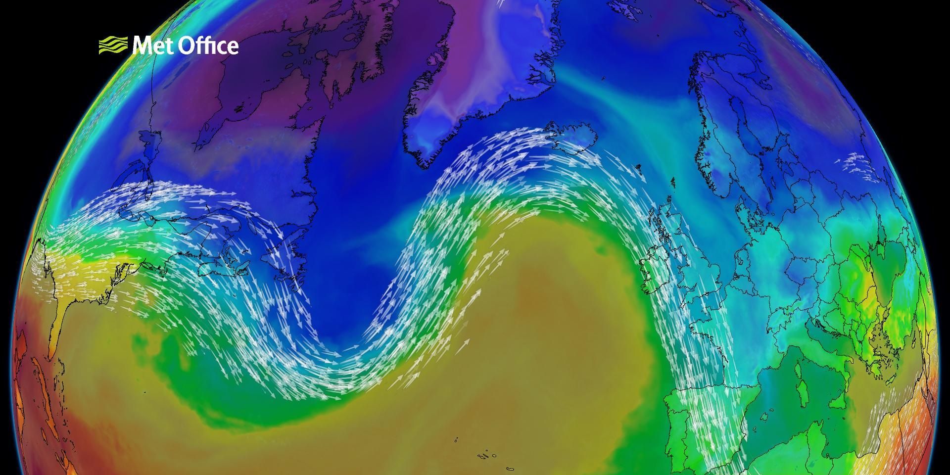
This week’s Deep Dive takes a closer look at a major driver behind the UK’s weather over the coming days: a positive phase of the North Atlantic Oscillation, often shortened to NAO.
This large‑scale atmospheric pattern strongly influences the position and strength of the jet stream, ultimately shaping the weather we experience at the surface. With a distinctly positive North Atlantic oscillation setting up across the North Atlantic, the coming week promises mixed, changeable and frequently unsettled conditions.
In this blog, we explore why this is happening, what the implications are, and how things may evolve as we move deeper into March.
What is the North Atlantic oscillation?
The NAO describes the pressure difference between a region of typically low-pressure near Iceland and an area of generally higher pressure over the Azores. When both of these features strengthen, lower pressure than usual over Iceland and higher pressure than usual near the Azores, we get a positive NAO. Conversely, when the pattern weakens or reverses, we see a negative phase.
In its positive phase, the NAO tends to produce a stronger and more powerful jet stream aimed from the Atlantic towards the UK and northern Europe. This fast‑moving ribbon of air acts as a conveyor belt for areas of low pressure, sending a succession of weather systems across the country. The result is typically unsettled weather characterised by spells of rain, frequent showers, and strong winds.
Blocking patterns and why they matter
As well as the NAO, European blocking is another important concept. Blocking refers to large areas of high pressure that can disrupt or divert the jet stream. When blocking is strong, weather systems may stall, be diverted northwards, or be prevented from crossing the UK at all.
This week, however, ensemble forecasts show that most simulations sit firmly in the positive NAO zone, with little evidence of significant blocking over Europe. This suggests that although occasional subtle deflections are possible, the dominant signal remains one of a strong, progressive jet stream pushing systems through.
Why the jet stream matters this week
The jet stream has recently been energised by powerful storms over the eastern United States. As these systems intensify, they inject additional energy into the upper atmosphere, helping to strengthen downstream jet flow. That energy is now arriving over the North Atlantic, and the UK is directly in its path.
READ MORE: What is the jet stream and how does it affect our weather?
The practical result is clear: a sequence of Atlantic lows will cross the UK through the week, bringing alternating spells of rain, showers and strong winds. The jet stream will be particularly active into Wednesday, pushing tightly packed isobars towards northern Scotland and leading to the strongest winds of the week. Gusts of 60–70 mph are likely in exposed parts of northwest Scotland, with the risk of even higher gusts in the most exposed locations.
Sunshine and showers follow the frontal systems
As each frontal system clears, brighter spells develop before the next area of low-pressure approaches. This is a classic “sunshine and showers” setup, common beneath a positive NAO, where colder air aloft creates enough instability for showers to form readily. Showers will be most frequent in the west and northwest, with some turning heavy and lively, accompanied by hail, thunder, or wintry flakes over higher ground.
The southeast, by contrast, often fares better in these patterns, with longer dry spells and occasional sunshine between weather systems.
A sharp dip in temperature later in the week
A noticeable downturn in temperatures will arrive from Thursday into Friday as colder air is drawn south behind an active frontal system. By Friday morning, daytime highs across much of the UK fall below the seasonal norm.
A useful way to measure this is the freezing‑level height, the altitude at which the temperature reaches 0°C. On Thursday morning this level sits high, meaning snow is unlikely apart from the tops of the highest Scottish mountains. By Friday morning, however, the freezing level lowers dramatically across Scotland, Northern Ireland and parts of northern England. This increases the chance of hill snow and even the possibility of brief lower‑level snow showers in northern areas. The majority of any accumulation will be confined to hills, but transient wintry showers are possible in the north and northwest.
READ MORE: Week ahead: A brighter start, but turning much wetter
Rainfall patterns: where will it be wettest?
Consistent with a positive NAO, rainfall distribution is not uniform across the UK. Western Scotland, northwest England, west Wales and Northern Ireland are expected to see the highest rainfall totals over the next week. This is because the prevailing south-westerly winds repeatedly push moist Atlantic air against western uplands, enhancing rainfall through orographic uplift. Meanwhile, eastern and southeastern parts of England experience more shelter and are likely to remain comparatively drier, despite occasional fronts reaching these areas.
Looking further ahead: signals of change
The Deep Dive also explores ensemble forecast data across the next two weeks. For the near term, the positive NAO remains dominant, meaning further unsettled spells into next week with more low‑pressure systems tracking across the country. However, as we progress later into March, subtle shifts begin to appear.
Ensemble clusters suggest a weakening jet stream and an increasing chance of European blocking by mid‑month. This does not guarantee a shift to settled weather, but it increases the likelihood of a pattern change. Depending on where any blocking high becomes established, two broad scenarios are possible:
- Blocking to the north or northeast of the UK
This would allow low pressure to dive south across the UK, increasing the chance of rain for southern areas and potentially cooler conditions. - Blocking closer to or over the UK
In this case, the jet stream would be diverted to the northwest, giving the UK a drier, more settled spell, more typical of a “summer NAO” pattern, even in spring.
These possibilities represent the key questions meteorologists will be monitoring over the coming weeks. The broad message is that while the next 7–10 days look decidedly changeable, signs of a shift become more apparent later in the month.
What this means
For now, expect a dynamic week of weather: wet and windy spells, frequent showers, occasional sunshine, and a mid‑week temperature dip bringing pockets of hill snow in the north. Conditions will change quickly, so keeping up with short‑range forecasts is particularly important.
As always during periods of strong winds, stay aware of any warnings issued for your area. Travel disruption is possible where gusts are highest, especially across northern and western Scotland, and heavy rain may lead to localised impacts in western regions.
You can find the latest forecast on our website, on YouTube, by following us on X and Facebook, as well as on our mobile app which is available for iPhone from the App store and for Android from the Google Play store.