There has been growing interest this week in the possibility of so‑called “blood rain” affecting parts of the UK.
With Saharan dust already on the move across Europe and Atlantic weather systems heading our way, the question many people are asking is whether the UK could see discoloured rainfall on Wednesday or Thursday.
Here, we explain what this phenomenon really is, how it forms, and what we can expect in the days ahead.
What blood rain actually is
The term “blood rain” often captures attention, but it can be misleading. It is not a scientific phrase, nor does it describe a frequent or clearly defined meteorological event. Instead, it simply refers to rain that takes on a reddish tint once it reaches the ground. The colour can vary from a faint rusty hue to deeper reds, depending on how much dust is present in the atmosphere at the time of rainfall.
For rain to appear red, relatively high concentrations of red‑coloured particles must mix with the water droplets in the cloud. Typically, these particles are sand or dust rich in iron oxides, giving them their characteristic colour. When rainfall occurs while these particles are suspended in the atmosphere, the droplets can take on that tint.
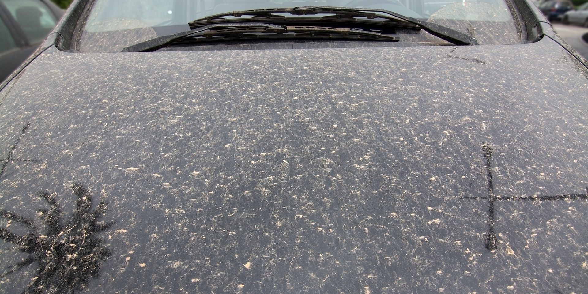
In practice, however, genuinely red rain is extremely rare. While dust‑laden rain is not uncommon in the UK, the concentration of particles is usually low, resulting in rain that looks normal to the naked eye. Only after the rain dries might you notice a thin film of dust left on cars, windows, or outdoor surfaces.
READ MORE: February & Winter weather stats: A regional breakdown
The forecast for this week
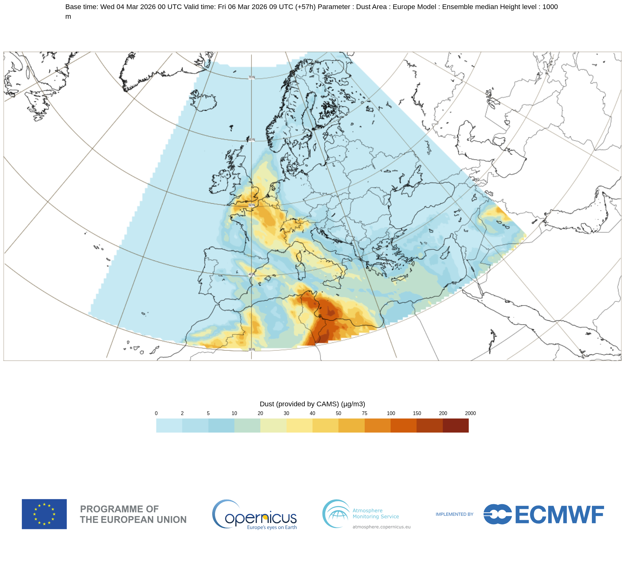
This week, Saharan dust is once again being transported northwards across parts of Europe and towards the UK. Current assessments suggest that concentrations will pass close to or just south of the UK, but a brush of dust‑influenced air is likely, particularly affecting southern parts of the country.
By Wednesday and Thursday, the combination of a moist south‑westerly airflow and a broad dust plume could lead to some dust settling out with the rain. At this stage, concentrations are expected to remain relatively low, meaning rainfall itself is unlikely to appear noticeably red. Instead, where dust mixes in, the impact is more likely to be seen after showers have passed, with a light film of yellowish or brownish residue on surfaces.
For those in the southwest, the timing of the rainfall will be a key factor. Overnight showers or early‑morning rain on Thursday could leave dust deposits by dawn. Elsewhere across the UK, dust levels are currently forecast to remain even lower, with largely unremarkable rainfall expected.
While Saharan dust itself is a natural particle, its presence in the atmosphere can contribute to higher overall particulate levels. Light winds and more stable conditions, especially across southern and eastern parts of the UK, will limit how quickly the dust disperses. This makes it easier for locally generated pollution to build up.
What to expect and what to do
For most people, the effects of dust‑laden rain this week will be minimal. You may notice:
- A light coating of dust on vehicles or windows.
- Slightly reduced visibility at higher altitudes if the dust layer is particularly concentrated.
- Vivid sunrises or sunsets, as airborne dust can scatter sunlight and enhance colours.
There is no need for concern from a health perspective for the levels currently expected over the UK. Those with respiratory sensitivities may notice a slight increase in airborne particulates before rainfall clears the atmosphere, but concentrations should remain well below levels associated with air‑quality alerts.
If you’re planning to wash your car, waiting until the end of the week may be wise, as additional dust pulses could reach the UK before conditions settle.
READ MORE: Contextualising February’s warm spell: A notably mild end to winter
How dust travels to the UK
The journey Saharan dust takes to reach the UK is both impressive and surprisingly common. Powerful atmospheric systems such as thunderstorms, strong surface winds or large‑scale weather patterns can lift sand and dust from desert regions into the air. Once airborne, these particles can be transported thousands of miles by prevailing winds and atmospheric circulation.
The Sahara Desert is one of the world's largest sources of airborne mineral dust, and each year plumes of this dust are carried northwards. Sometimes these plumes remain aloft and pass overhead unnoticed. At other times, they mix into cloud layers. When this happens, there is potential for the dust to fall out during rainfall events.
The key factor determining whether any coloured rain occurs is the concentration of dust within the rain cloud. Even though dust transport is a regular occurrence, we need a relatively high concentration of particles within the rainfall for it to be noticeable at the surface.
Historical examples and context
While the term “blood rain” has appeared in historical accounts, sometimes described as an omen, it has almost always been used loosely. In recent centuries, most credible scientific accounts of discoloured rain relate to one thing: dust transport.
One of the most notable modern examples occurred in the early 2000s in Kerala, India, where rain containing unusually high concentrations of red particles stained clothes and surfaces. Events like that underline that visible coloured rain is possible, but they also highlight how unusual it is.
In the UK, documented cases of truly red rain are extremely limited. What we normally experience instead is rain that washes dust out of the atmosphere in small amounts. The result is often an early‑morning surprise for motorists who wake to find their vehicles coated in a light dusty film.
At this stage, while dust‑enhanced rain is likely in some areas, the dramatic “blood rain” suggested in some headlines is highly unlikely.
You can find the latest forecast on our website, on YouTube, by following us on X and Facebook, as well as on our mobile app which is available for iPhone from the App store and for Android from the Google Play store.