
Summer 2025 went down as provisionally the warmest on record for the UK, but how accurate was the Met Office forecast through the season? We crunch the numbers to find out…
The warmest summer on record, drought status for many, thunderstorms and even Storm Floris; Summer 2025 brought its fair share of impactful weather.
Summer is typically the season which can be hardest for UK forecasters. A lack of underlying global drivers, as well as the prominence of small-scale but impactful weather like thunderstorms, means that developing the forecast, especially at longer ranges, can be a complex task. Small-scale features like thunderstorms can often significantly influence accuracy metrics, not only for rainfall, but also for wind speed and direction.
Here, we assess how accurate the forecast was through meteorological summer (June, July and August), as well as the impact it had on people, industry, and government.
How accurate was the forecast through the season?
Met Office forecast accuracy is routinely assessed in a wide variety of ways of ways, but the below figures are informed by forecast verification at around 120 sites around the UK, giving geographical spread across the UK. As a general rule, UK forecast accuracy increases incrementally and upcoming developments around new supercomputing infrastructure, satellite projects and the advancement of AI could accelerate these improvements in the coming years.
Temperature forecasts are deemed to be ‘accurate’ if they’re correct within 2°C of the verifying observation.
For maximum temperature forecasts in the season, 1-day forecasts were 93% accurate, with 73% accurate at the 5-day range. Of course, some of the most notable weather over the summer came in the form of heatwaves, when there may be particular focus on forecast accuracy. Of the maximum temperature observations that exceeded 30°C over the summer, over 90% of the forecasts were forecasting temperatures above 28°C at three days ahead, and over 70% of the forecasts were forecasting temperatures over 28°C at four days ahead.
Minimum temperature forecasts were similarly accurate. 1-day forecasts were 89% accurate by this metric, with this dropping to 70% at the 5-day range.
Wind speed is assessed as accurate if it’s within five knots of the verifying observation. 1-day forecasts were 93% accurate, with 84% accuracy at the 5-day range.
Wind direction is deemed as accurate if it’s within one compass point on a 16-point compass (22.5 degrees). 1-day forecast accuracy for this was 88% accurate, with this dropping to 57% at the 5-day range.
Met Office Director of Science Simon Vosper leads the scientific work on weather modelling, which is the basis of forecasting.
He said: “Summer is famously tricky for weather forecasting in the UK. A lack of global drivers compared to winter, coupled with the potential for small-scale impactful weather, means that it can be a challenging period to forecast. However, accuracy above 90% for the majority of 1-day forecast metrics and above 70% for the majority of 5-day metrics is good performance.”
“I’m immensely proud of the work of our teams in ensuring forecast accuracy through the season, working through the details and complexities of what the UK weather can throw at us. I’m particularly pleased to see the accuracy around the temperature figures, especially given the importance of this as we experience more frequent and prolonged heatwave events.”
How useful were weather warnings during summer 2025?
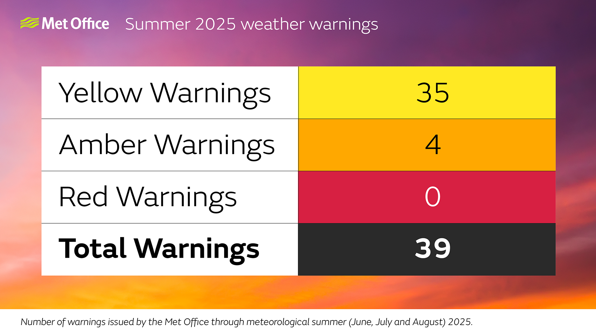
A total of 39 warnings were issued over meteorological summer, which eclipsed the 12 issued over the three months of meteorological spring.
Naturally, there were revisions to many of these warnings as forecast confidence increased, but the 39 warnings included 35 that were Yellow, and four that were Amber.
The most impactful weather, associated with the amber warnings, was for thunderstorms, but also Storm Floris.
While the number of warnings can be a good indicator of how much impactful weather has been had over a season, Met Office warnings exist to be useful for the public, businesses and government. That’s why, after severe weather events, the Met Office routinely undertakes research in the worst-hit areas to check the effectiveness of warnings.
Storm Floris brought widespread transport disruption in Scotland and a station at Caithness recorded a gust of 82mph, equalling Scotland’s August gust speed record. According to Met Office post-event research, 93% of those within the Amber warning area were aware of the warning, with 83% of those taking action as a result. 92% found the warning useful.
Another period of impactful weather was around the Amber thunderstorm warning in the southeast of England on 19 July. Thunderstorms are more hit and miss in nature, which means warnings of this kind are famously tricky to get right for everyone.
75% of those within the Amber warning area were aware of it, with 76% of those taking action and 87% finding it useful. While not as impressive as the Storm Floris figures, it still matched or eclipsed the average figures for thunderstorm warnings issued by the Met Office.
Simon Brown is the Managing Director of Products and Services at the Met Office. He reflected on how the summer forecast benefited users of Met Office services. He said: “Summer weather can be impactful for people and it’s no different to users of Met Office services. Whether it’s aviation, infrastructure or business, we’ve helped to empower decision makers across the UK over the season.”
How did people access the forecast?
As always, Met Office forecasts were seen by the public online, on TV and on the Met Office app, as well as Met Office data underpinning forecasts on other sites.
The most popular day in the season on the Met Office website was 21 June as a widespread heatwave continued for many, with 2.3million web sessions on the day. For the Met Office app, 19 July was the most popular day, with 5.1million app sessions as an Amber thunderstorm warning came into force in the southeast of England.
Social media remained a popular method of getting the Met Office weather forecast. Over 11million views on the Met Office YouTube Channel, with the most popular video focusing on Storm Floris. There was a 30% increase in subscribers on this channel compared to meteorological spring.
In addition, Met Office content got over 36million impressions on X over the season, with the most popular content again coming from the more severe periods of weather, as well as the heatwaves during the season.
Met Office forecasts aren’t just communicated through social media and the wider media, an expert team of Civil Contingency Advisors work around the clock informing government, businesses and stakeholders on the coming forecasts and the risks with it. Over meteorological summer, 175 weather briefings took place, including 34 incident briefings in response to impactful weather.