
Dry weather was the main focus for meteorological spring, with potential drought on the cards in some regions, as well as some short-term weather hazards.
Spring was provisionally confirmed as the UK’s warmest and sunniest on record, as well as the sixth driest. However, the season had fewer instances of severe weather, with a subsequent decrease in warnings from previous months. So just how did the Met Office forecast develop and how was it used? We take a look…
Light on warnings but not on some impacts
Spring can typically be a season with a mixture of weather hazards, with storms, snow and fog frequently bringing impacts.
However, Spring 2025 offered less in the way of impactful short-term weather, and more in the way of longer-term discussions about rainfall amounts for nature and industry.
Just 12 Met Office National Severe Weather Warnings were issued, making it the fewest issued during spring since 2015, when 10 were issued. For context, 105 warnings were issued during Spring 2018, which included the infamous ‘Beast from the East’.
The season’s warnings were all in the Yellow category with six warnings for rain, four for fog and one each for ice and thunderstorms. No storms were named by the Met Office’s storm naming group during meteorological spring.
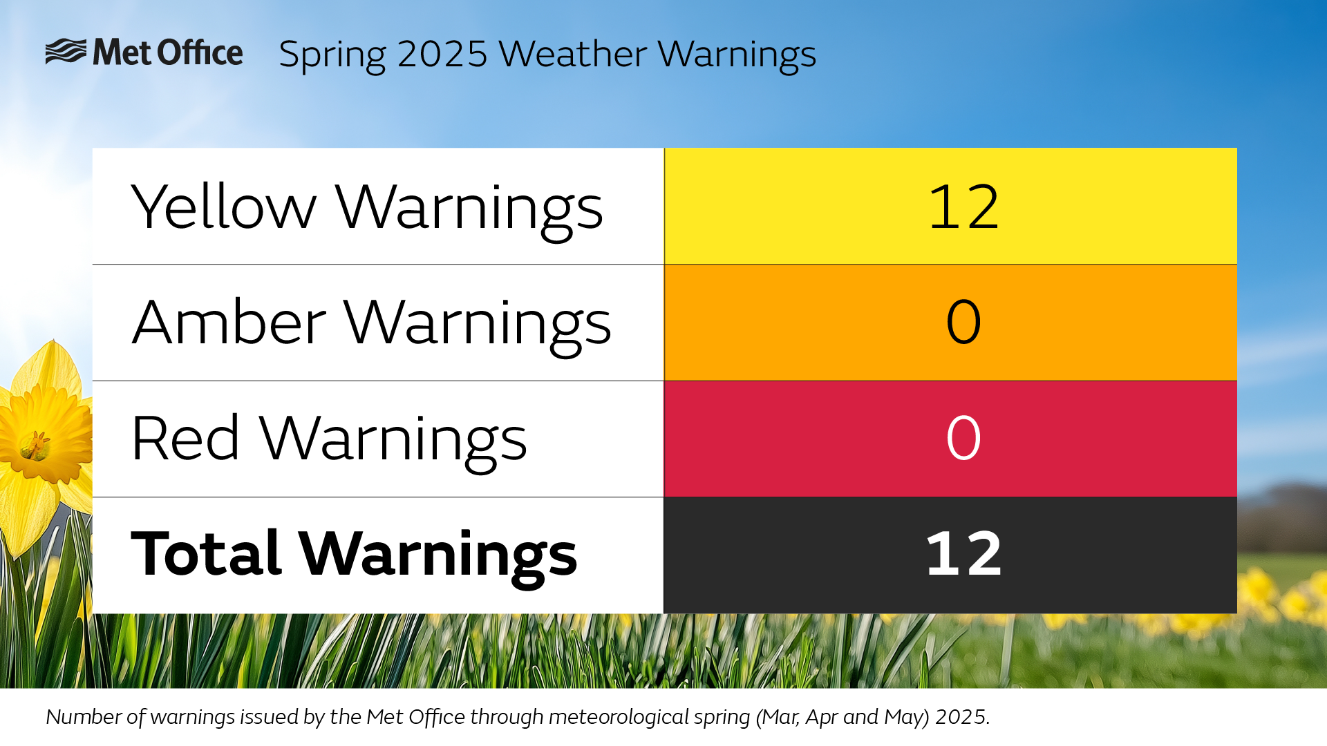
A lack of rain became the main ‘impact’ from the weather over the course of the season, with just 56% of the average amount of rain in the season. A number of Met Office briefings kept the public, government and industry abreast of the latest forecast, providing trusted weather and climate intelligence when it mattered.
Met Office Director of Science Simon Vosper said: “Spring 2025 has demonstrated our role as the UK’s national forecaster; providing consistent, trusted information, even during calmer weather.
“Our forecasting capability helped predict the unusually warm weather in May, as well as getting to the local details of warnings for fog, ice, rain and thunderstorms.”
“Weather models have demonstrated remarkable capability in assessing the longevity of the dry periods we’ve seen. High resolution ensemble models were used to predict the ongoing probabilities of the breakdown of settled weather, helping to provide clarity for planners.”
One interesting challenge for weather models in spring can be for predicting cloud amounts accurately, which can have a big impact on the accuracy of temperature and sunshine forecasts.
Simon explained: “Once you get into the detail of forecasting specific cloud amounts in specific locations, it takes a certain amount of skill, from both weather models and meteorologists, to accurately forecast temperature and sunshine in the day, which can make a big difference for users. It has taken tremendous skill through the season getting into the details of some of these events.”
Extraordinary season over land and sea
A marine heatwave for northwest European waters influenced the ongoing meteorological outlook, which saw sea surface temperatures rise to record breaking levels for the time of year.
Simon commented: “The prolonged sunshine wasn't restricted to land, the settled and sunny weather also caused sea surface temperatures around the UK and Ireland to reach extreme marine heatwave criteria.
“Indeed, the temperatures reached levels not recorded at this time in the year since monitoring started in the 1980s. This phenomenon not only has an impact on marine ecology, it can also influence the weather over the UK. A study on the marine heatwave of May2024 found that this warmed average temperatures over land by 0.5C over the course of the month.”
Communicating the forecast
Met Office Civil Contingencies Advisors, celebrating 20 years since their creation, conducted multiple briefings this Spring. These helped local and national responders to prepare for the ongoing weather, including the prolonged dry weather many experienced.
Met Office Managing Director for Products and Services Simon Brown, who works to ensure Met Office information can be used effectively for a range of sectors, reflected on the season.
He said: “The focus for us through much of Spring has been on how our information can help partners with the weather we’re expecting, enabling them to make better decisions. That goes from those looking after water resources and energy use through to those who simply want to make the most of the warmer weather.
“Our teams have been working to communicate the latest weather outlook, helping everyone to make better decisions around the weather. Much of this works remains behind the scenes, with steps taken in various sectors to mitigate any impact on the public from the prolonged dry weather we’ve seen.”
Accessing the forecast
Over 12million unique users visited the Met Office website during Spring, with a further 3.9million users of the Met Office app.
Late spring proved to be the most popular individual date across Met Office’s website and app, with 27 May, during the wet start to half term for some, seeing the most sessions on the website and app.
The Met Office’s direct social media presence was once again a consistent source of many people’s interactions with the forecast. Over 141million impressions were generated across Met Office channels on Facebook, Instagram, X, YouTube, TikTok and LinkedIn.
With meteorological summer already upon us, interest in the weather is sure to continue in the coming months, with forecasting conundrums likely around potential warmth, thunderstorms and other summer weather hazards.