Over the past week, we've seen significant winds from Storm Floris, while another system lingers on the horizon.
In this week’s deep dive, we reflect on the passage of Storm Floris, assess the potential influence of tropical storm Dexter, and take a closer look at July’s climate statistics and what they mean for the summer as a whole.
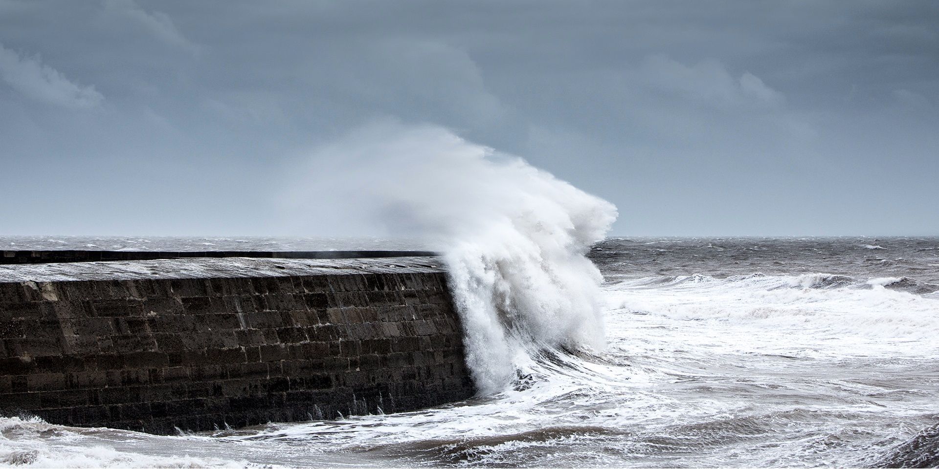
Storm Floris brings record-equalling gusts
Storm Floris has now moved away from the UK, but its effects were widely felt. An unseasonably deep area of low pressure, Floris swept across the country, particularly impacting Scotland and Northern Ireland with heavy rain and strong winds. The strongest gust recorded was 82 mph at Wick in Scotland, equalling the country’s all-time August wind gust record.
Storm Floris has now cleared the UK, and is tracking across Norway today
— Met Office (@metoffice) August 5, 2025
Here’s a 24 hour satellite view showing Floris crossing the UK on Monday 🛰️ pic.twitter.com/4NT5fqemuZ
While not surpassing the UK’s overall August record of 87 mph, set at the Needles on the Isle of Wight in the late 1980s, Floris was nonetheless a significant wind event. Several stations came close to or exceeded their local August records. The timing of the storm, during peak summer, meant greater potential for disruption due to trees in full leaf and increased outdoor activity. Travel was affected, and there were reports of trees down across rail lines.
Jet stream remains active
The jet stream continues to play a key role in shaping our weather. It remains relatively strong for the time of year and was instrumental in intensifying Floris. With the jet stream running across the UK, other low-pressure systems are tracking nearby, though most are expected to pass further north than Floris did.
A brief ridge of high pressure is building in, bringing a short-lived spell of more settled weather. This will lead to a fresher night, with temperatures dipping into the mid-single figures in some areas.
READ MORE: July 2025 weather stats: A regional breakdown
A complex frontal system ahead
Attention now turns to a frontal system approaching from the northwest. This feature is proving tricky to forecast due to its splitting structure. A cross-section of the atmosphere reveals a leaning front with higher wet bulb potential temperatures, indicating instability. This could lead to the development of heavy, possibly thundery showers along the front.
The most likely areas to see significant rainfall include northwest England, Snowdonia, and the western Highlands, with totals potentially reaching 25–35 mm in the wettest spots. While not expected to cause major disruption, this is being monitored closely.
Tropical storm Dexter and its Atlantic journey
Looking further ahead, tropical storm Dexter is currently situated in the western Atlantic. Forecasts suggest it will move eastwards towards the UK, though it will be heavily modified by the time it arrives. Dexter is unlikely to retain tropical characteristics but could still be a potent low-pressure system.
An upper trough is expected to interact with Dexter, helping it maintain momentum across the Atlantic. While tropical systems often weaken over cooler waters, this trough could deepen the low and sustain its energy. Some models currently show Dexter tracking to the northwest of the UK as a relatively deep feature. Another model, however, suggests a more southerly track with less impact.
READ MORE: Are storms in August unusual and why do we name them?
A minority of model runs present a more intense scenario, with pressure in the 970s hPa and a track closer to the UK. While it’s too early to confirm the exact path and strength, Dexter is one to watch. If it reaches naming criteria, it would retain its current name rather than adopting the next UK storm name, Gerben.
July’s climate statistics and summer trends
July came to a close with some notable climate statistics. Despite the focus on Storm Floris, the month was warmer than average, the fifth warmest July on record. This marks the sixth consecutive month of above-average temperatures and the fifth in a row to rank in the top ten warmest for its respective month.
Regional data shows that parts of northern Scotland, eastern England, and the southeast experienced their top five warmest Julys. Most other areas were within their top ten. Rainfall was more variable, with southwest England and parts of Wales markedly drier than average, while Kent and Sussex saw wetter conditions. Nationally, rainfall was near normal, but this masks significant regional differences.
As we head into the weekend and next week, high pressure is expected to return, bringing more settled conditions. Southern areas are likely to remain largely dry, while the northwest may continue to see cloudier, wetter, and windier spells due to nearby low-pressure systems.
The potential for hot weather is increasing, particularly in southern and central parts of the UK. While not expected to be extreme, temperatures could feel quite warm, especially in sunny spells with lighter winds.
Keep up to date with weather warnings, and you can find the latest forecast on our website, on YouTube, by following us on X and Facebook, as well as on our mobile app which is available for iPhone from the App store and for Android from the Google Play store.