After a period of high pressure and settled, if somewhat gloomy, conditions, the weather has taken a dramatic turn.
This week, low-pressure is firmly in charge, bringing wet and windy weather to many parts of the country. In this blog, we’ll break down what’s driving these changes, what to expect in the coming days, and the meteorological processes at play.
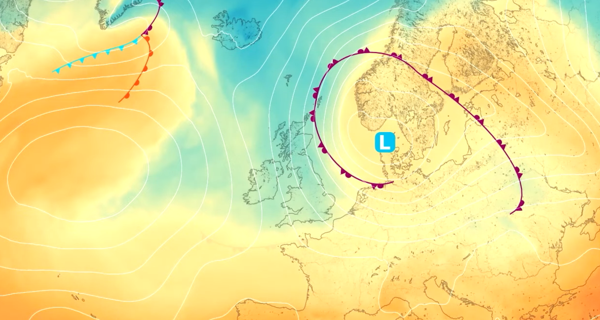
A shift from anticyclonic gloom to dynamic low pressure
Last week, the UK was under the influence of high pressure, resulting in dry and settled weather. However, this was accompanied by persistent cloud cover, what meteorologists often refer to as “anticyclonic gloom.” While rainfall was limited, sunshine was also in short supply.
This week, the pattern has shifted dramatically. A developing area of low pressure is moving in, and with it comes a marked increase in both wind and rain. The change is already being felt, with the Met Office issuing wind and rain warnings for several regions. Let’s take a closer look at the details.
Wind warnings: Where and when to expect the strongest gusts
The most significant changes will be felt from Wednesday afternoon onwards. Initially, winds will be light, and Wednesday is likely to start as a relatively pleasant day, dry, bright, and sunny for many, with only scattered showers. However, as the day progresses, the approaching low-pressure system will begin to make its presence felt.
Storm Benjamin has been named by @MeteoFrance
— Met Office (@metoffice) October 22, 2025
We are likely to see impacts from wind and rain across the UK tonight and tomorrow with yellow warnings issued ⚠️
Stay updated 👉 https://t.co/QwDLMfRBfs pic.twitter.com/VN7nsrRjLP
By late Wednesday and into Thursday, winds will strengthen, particularly along exposed coasts. The western coast of Wales, parts of the southwest, and some southern and southeastern areas are most at risk from between 6am and 3pm. The wind direction will be predominantly northerly, meaning that the strongest gusts in southern England will often be offshore between 12am and 9pm. Nevertheless, exposed windward coasts could see gusts of 50 to 60mph.
As the low-pressure system drifts eastwards through Thursday, the strongest winds will become more confined to eastern areas between 3am and 11:59pm. Again, the most severe gusts are likely to be offshore, but exposed coastal locations could still experience significant impacts. Even inland areas will feel breezy and gusty at times, and the breezy conditions are expected to persist into the weekend.
Rainfall: Persistent downpours and localised flooding risk
Alongside the wind, the low-pressure system will bring substantial rainfall. Model projections indicate that the most affected areas will be in the southeastern half of the country, including central England, Lincolnshire, East Anglia, and parts of the south and southwest.
Rainfall totals are expected to reach 20 to 30 millimetres widely, with higher amounts possible in hilly or exposed areas where persistent downpours occur. Most places can expect around an inch of rain, but some could see 30 to 50 millimetres, especially where the rain is most intense. As the system moves eastwards, the heaviest rain will become more confined to eastern regions, but totals could continue to rise into early Friday before the low finally clears away.
Weather warnings and potential impacts
Given the combination of strong winds and heavy rain, the Met Office has issued several weather warnings. These are based on the potential for impacts, particularly in highly populated areas. The main wind warning covers eastern areas, including Lincolnshire, East Anglia, southeast England, and London. A secondary wind warning is in place for the western coast of Wales and the western and northern coasts of Devon and Cornwall.
READ MORE: Met Office weather stations: How we measure the weather
The initial warning for Wales and southwest England is valid from 6am and 3pm on Thursday, while the eastern warning runs from 9:00am to midnight. Wind speeds of 40 to 45mph are expected widely, with coastal areas potentially seeing 50 to 60mph. In eastern regions, gusts could reach 65mph or more if the low deepens further.
A rain warning has also been issued for much of the south and southeast, where persistent rain could lead to localised flooding. The combination of strong winds and trees still in full leaf increases the risk of fallen branches and travel disruption, particularly on railways where leaves can create slippery surfaces.
The science behind the forecast: Jetstream dynamics and model uncertainty
One of the most interesting aspects of this week’s weather is the role of the Jetstream and the resulting uncertainty in the forecast. The low-pressure system currently affecting the UK is being influenced by the position and strength of the Jetstream, a fast-flowing ribbon of air high in the atmosphere that often steers weather systems towards the UK.
This week, the main jet core is situated slightly further south than usual, with a secondary jet streak pushing in from the north. This complex upper-level pattern has led to differences in how weather models predict the track, timing, and intensity of the low-pressure system. As a result, there is greater uncertainty than usual, even at relatively short lead times.
Areas of low pressure that are picked up by the Jetstream can undergo rapid deepening, a process known as cyclogenesis. However, in this case, the low does not deepen significantly until it moves away from the Jetstream and into the North Sea later on Thursday. This delayed intensification is a key reason why the system is not currently a named storm.
Why isn’t this a named storm?
The Met Office, in partnership with Met Éireann and the Danish Meteorological Institute, is part of a northern European group responsible for naming storms that are expected to have significant impacts. In this case, while the low-pressure system is bringing wet and windy weather, it is not expected to reach the threshold for naming by the Met Office. However, the French meteorological service, Météo-France, has named the system Storm Benjamin due to the impacts the country is expected to experience.
READ MORE: What are October's current weather records?
The decision not to name the storm reflects both the expected impacts and the fact that the system is affecting several countries, each with its own criteria for naming.
The role of positive vorticity advection and upper troughs
While the Jetstream is often the main driver of low-pressure development, this week’s system is also being influenced by positive vorticity advection associated with a deep upper trough building into the North Sea. This process helps to intensify the low by promoting rising air and lowering surface pressure, particularly to the east of the trough.
As the low moves into the North Sea, this upper-level support helps to maintain its strength, resulting in continued gusty winds across eastern parts of the UK. However, because the system is not undergoing rapid deepening while over the UK, the impacts are less severe than might otherwise be the case.
Temperatures: a chilly spell ahead
With the low-pressure system bringing in a northerly flow, temperatures are set to drop as we head into the weekend. While daytime highs will be around average, 14 to 16°C on Wednesday, temperatures will fall into the high single figures or low teens by the weekend. The wind chill will make it feel even colder, especially in northern areas and across Scotland, where wind chill values could be as low as 3°C in places like Aberdeen.
This chilly spell is expected to be brief. As high pressure builds to the west, the flow will turn more westerly, bringing milder and wetter conditions, particularly to the northwest. The weather will remain changeable into next week, with a mix of rain, brighter spells, and fluctuating temperatures.
What to expect for half-term and Halloween
The timing of this unsettled spell coincides with the start of half-term for many across the UK. While the week has begun on a wet and windy note, conditions are expected to settle down over the weekend, with the risk of showers and even some wintry showers over Scottish mountains. However, widespread snow is not expected, despite some media speculation.
READ MORE: How the Met Office helped pave the way for UK commercial space launches
As high-pressure builds, there is the potential for some drier and brighter weather next week, although rain will return at times, especially in the northwest. For those planning outdoor activities such as pumpkin picking or Halloween celebrations, it will be important to wrap up warm and secure any decorations, as it will remain chilly and breezy.
With the weather remaining unsettled and warnings in force, it is important to stay up to date with the latest forecasts and advice. The Met Office website and social media channels provide regular updates, including any changes to warnings or the potential for more severe impacts.
This week’s deep dive highlights the dynamic nature of the UK’s weather and the complexity of the meteorological processes involved. From the influence of the Jetstream and upper troughs to the challenges of forecasting in the face of model uncertainty, the current spell of wet and windy weather is a reminder of why staying informed is so important.
While the impacts are not expected to be severe enough to warrant naming the storm, the combination of strong winds, heavy rain, and a brief cold snap will be felt by many. As always, the Met Office will continue to monitor developments and provide the most accurate and timely information possible.
Keep up to date with weather warnings, and you can find the latest forecast on our website, on YouTube, by following us on X and Facebook, as well as on our mobile app which is available for iPhone from the App store and for Android from the Google Play store.