As autumn unfolds across the UK, the weather has taken a notable turn.
After a weekend marked by heavy rain and weather warnings, conditions have shifted to a dry and settled pattern, with chilly mornings becoming a familiar feature.
This deep dive explores the meteorological forces at play, the impact of high pressure, and the evolving outlook for the coming days and weeks.
High pressure dominates the UK
The recent spell of dry and settled weather is largely due to a persistent area of high pressure dominating the UK. High pressure systems are known for bringing stable conditions, clear skies, and cooler nights. Over the past few days, this system has kept rainfall at bay and led to widespread frost, particularly in rural areas. Temperatures have dipped below freezing in some regions, with Scotland experiencing the lowest temperatures overnight,
As the week progresses, the high pressure is forecast to drift eastwards towards Scandinavia and the Baltic Sea. This movement will gradually alter the wind direction, shifting from a northerly and north-westerly flow to a more east or south-easterly component. Such changes can influence local weather, bringing moisture from the North Sea and increasing cloud cover, especially in southern and southeastern parts of the UK.
We've got a change in type this week with high pressure dominating ⛅
— Met Office (@metoffice) September 21, 2025
Here's the latest on the week ahead 👇 pic.twitter.com/LIKwKshdrT
The midweek outlook: Chilly starts and sunny spells
Wednesday and Thursday are expected to remain largely dry and settled, with sunny spells breaking through the cloud. Mornings will continue to feel chilly, particularly in western areas, where frost and mist may linger before clearing. The change in wind direction will help moderate temperatures, making mornings feel less cold by Friday.
Daytime temperatures are set to remain around average for this time of year, with mid to high teens across many regions. The far southeast may see the warmest conditions, occasionally reaching the high teens. Despite the brisk northerly winds earlier in the week, which made it feel cooler, the overall temperature profile is not expected to change significantly.
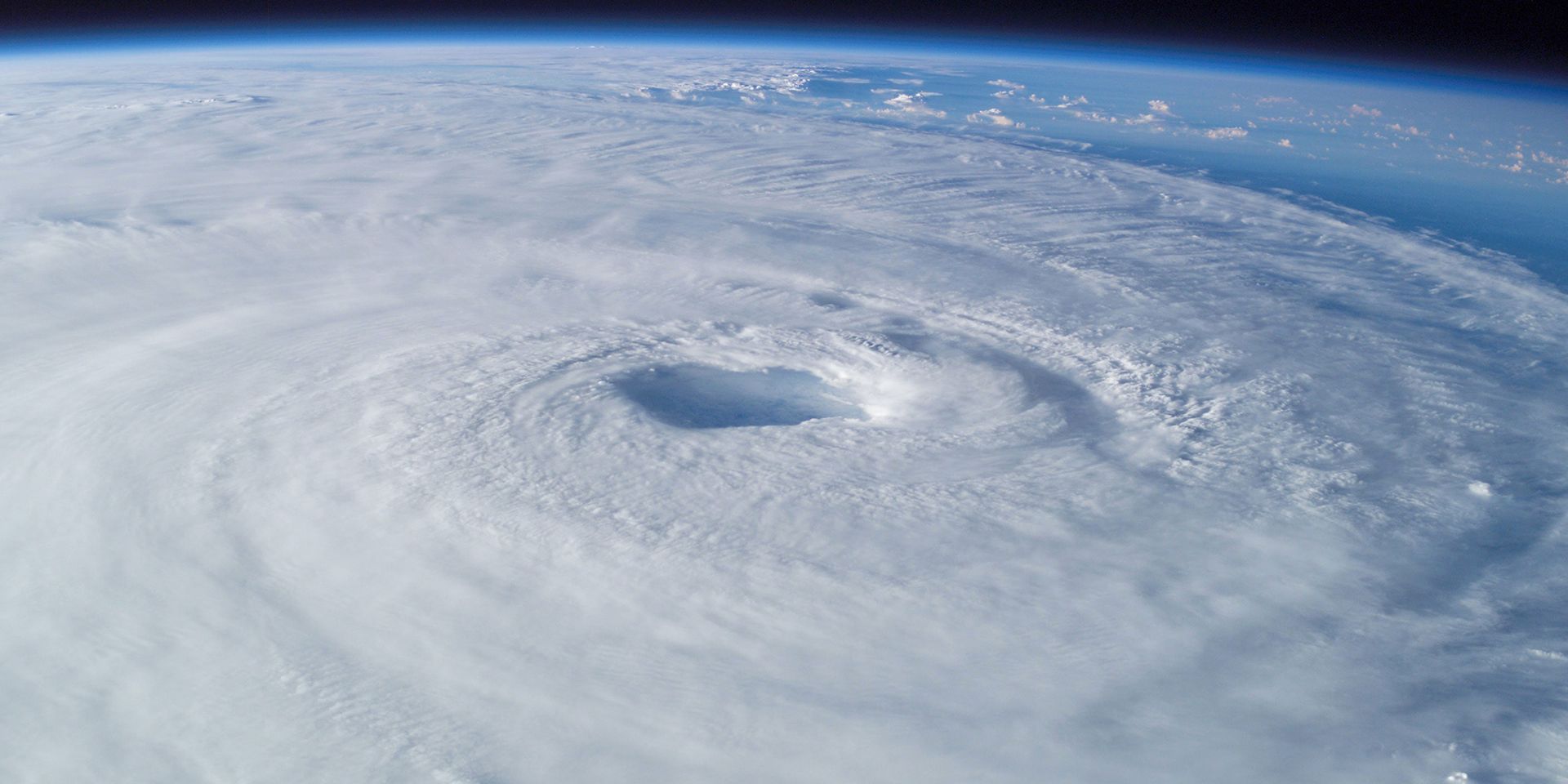
Weekend uncertainty: Hurricane Gabrielle and Atlantic disturbances
Looking ahead to the weekend, the forecast becomes more complex. The high-pressure system will continue to move east, allowing a new weather system to approach from the west. This system is linked to Hurricane Gabrielle, currently situated in the Atlantic and tracking towards the Bay of Biscay, Spain, and Portugal. There is a small chance, less than 5%, that Gabrielle could impact the UK directly with stormy conditions, but it is much more likely to affect southern Europe and the Azores.
READ MORE: Hurricanes, typhoons and tornadoes: What’s the difference?
Gabrielle has been a slow-moving feature, not fully picked up by the Jetstream, and has lingered in the Atlantic for several days. Its associated frontal system is expected to bring heavy rain and strong winds to the Azores, and possibly to parts of western Europe. The interaction between high and low-pressure systems will fuel a south to south-westerly flow, introducing warmer air into the southwest and western Wales.
Warm advection and forecast challenges
Warm advection, the process of warmer air moving into a region, can sometimes create a ridge of high pressure ahead of an approaching trough. This ridge may limit the intensity of rainfall as the system moves eastwards into southeast England. However, forecasting the exact track and impact of Gabrielle remains challenging. Small changes in the hurricane’s path could alter where the ridge forms and how much rain falls in different areas.
Forecast confidence has improved slightly, thanks to greater agreement among ensemble models about Gabrielle’s track and intensity. Nevertheless, uncertainty persists, especially regarding the potential for rain in central and eastern England. Even if Gabrielle does not cross the UK, its proximity could influence local weather fronts and contribute to unsettled conditions.
Atlantic hurricane season: A quiet peak
The Atlantic hurricane season was initially forecast to be above average, but activity has been relatively subdued so far. The first couple of weeks of September typically mark the peak of the season, yet only a handful of storms have developed. Early in the season, weak and short-lived storms such as Andrea, Barry, Chantal, and Dexter appeared, but it was Hurricane Erin in August that truly marked the start of significant activity.
READ MORE: A look back at the 2024/25 storm season
Erin, a classic Cabo Verde-type hurricane, formed near the Cape Verde Islands off western Africa and travelled across the tropical Atlantic. After a period of slow development, it explosively intensified north of the Caribbean, reaching category five status before transitioning into an extratropical storm and heading northeast. Erin disrupted the Jetstream and ended the warm, dry spell in late August.
Suppressed activity: Causes and consequences
Several factors have contributed to the quieter hurricane season. The Azores high, a persistent area of high pressure, was stronger and further south than usual, bringing drier and more stable air into the deep tropics. This suppressed the development of storm clouds and limited the energy available for tropical cyclones. Additionally, the West African monsoon was less potent, producing weaker and drier easterly waves. Wind shear over the Atlantic also played a role, disrupting the vertical structure of developing storms and preventing them from intensifying.
Despite the quiet spell, activity has begun to ramp up, with Hurricane Gabrielle and other disturbances now present in the Atlantic. The pattern is reminiscent of last year, when a slow start was followed by a surge in storms later in the season.
Hurricane Gabrielle: Development and future track
Gabrielle originated as a tropical storm in the deep tropics, struggling to organise until it moved north of the Caribbean. There, it rapidly strengthened to category four, aided by higher sea surface temperatures and favourable atmospheric conditions. The subtropics and mid-latitudes have seen above-average sea temperatures, which contributed to Gabrielle’s intensification.
Ensemble model forecasts suggest Gabrielle will continue eastwards towards the Azores, possibly maintaining hurricane status as it passes over the islands.
We've got a change in type this week with high pressure dominating ⛅
— Met Office (@metoffice) September 21, 2025
Here's the latest on the week ahead 👇 pic.twitter.com/LIKwKshdrT
African easterly waves and new disturbances
The Atlantic remains active, with two additional disturbances identified alongside Gabrielle. These waves, originating from Africa, are being closely monitored for potential development. One has a high probability of becoming a tropical storm and is expected to move north-westwards away from land. The other, with lower development probability, could strengthen near the Bahamas or southeast USA, posing a risk of rapid intensification and limited warning time for land impacts.
Ensemble predictions show two distinct clusters of potential storm tracks, with one likely to sit north of the Caribbean and the other closer to the Bahamas. The models indicate a possible threat of landfall, underscoring the need for vigilance as the season progresses.
Typhoon Ragasa: A powerful Pacific storm
While the focus has been on the Atlantic, the Western Pacific has also seen significant activity. TyphoonRagasa, which developed in the Philippine Sea, reached category five status and impacted islands north of Luzon in the Philippines. It is now moving towards southern China, with landfall expected between Hong Kong and Hainan Island. The storm’s oblique approach makes precise forecasting difficult, but strong winds and heavy rain are anticipated across southern China and northern Vietnam over the coming days.
Ragasais the strongest Western Pacific typhoon in nearly two years, marking a notable event in a season that has otherwise seen weaker storms. Its impacts are expected to be widespread and prolonged, affecting coastal areas and inland regions alike.
Keep up to date with weather warnings, and you can find the latest forecast on our website, on YouTube, by following us on X and Facebook, as well as on our mobile app which is available for iPhone from the App store and for Android from the Google Play store.