
January 2026 was marked by a mix of wintry outbreaks, persistent rainfall and strong regional contrasts across the UK.
While the month opened with a distinctly cold spell, it soon transitioned into a wetter, more unsettled pattern shaped by some significant storms.
These regional statistics highlight the diversity of conditions experienced across the country, with some areas recording exceptionally high rainfall while others remained comparatively dry.
A wintry beginning and shifting weather patterns
The month began under the influence of an Arctic airmass, which pushed southwards at the start of January and resulted in widespread frost, freezing fog, ice and snow across large parts of the UK. Scotland in particular saw extensive snowfall during the opening week. By 5 January, forecasters detected signs of a developing multi‑hazard event. This system, later named Storm Goretti by Meteo France, brought damaging winds to Cornwall and the Isles of Scilly on 8–9 January, prompting the first red wind warning of 2026. Goretti also delivered widespread snow across Wales, the West Midlands and the South Pennines.
As the month progressed, unsettled Atlantic weather became dominant. Scotland experienced heavy rainfall between 21 and 24 January, with the southeast particularly affected. Meanwhile, the southern half of the UK was impacted by two further named storms: Ingrid on 24 January, followed by Storm Chandra on 26–27 January. Chandra brought heavy rain and strong winds to the southwest, causing flooding in Devon and Somerset as already saturated ground struggled to absorb further rainfall. The rain later pushed northwards into Northern Ireland, where some of the heaviest monthly totals were recorded.
READ MORE: Why has it been so rainy?
Temperature patterns across the regions
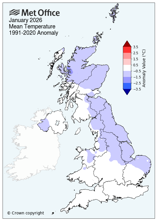
The first half of January featured temperatures that were below average for most of the UK, reflecting the presence of Arctic air and repeated wintry hazards. However, temperatures rose during the second half of the month, leaving some regions around or only slightly below average overall. The UK’s provisional mean temperature for January was 0.5°C below average.
The regional statistics reveal colder‑than‑average conditions particularly in Scotland. Northern Scotland recorded a mean temperature 1.0°C below average, while eastern Scotland was 0.8°C below and western Scotland 0.4°C below. In England, East and Northeast England saw a mean temperature 0.8°C below average, and the Midlands and East Anglia finished 0.4°C and 0.5°C below average, respectively. Northern Ireland also ended the month 0.4°C below average.
Further south, temperatures were closer to average, with the southwest of England and Wales seeing conditions slightly above average at times, reflecting the influence of milder Atlantic systems. England Southeast and Central South reached a mean temperature equal to the long‑term average, making it one of the few regions not to record a negative anomaly.
Rainfall: strong regional contrasts
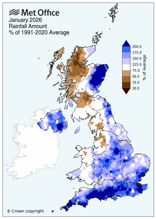
Rainfall was a defining feature of January 2026. The UK recorded 117% of its long‑term average rainfall for January, but this figure masks striking regional differences. Some areas experienced exceptional rainfall totals, while others remained relatively dry.
Northern Ireland saw some of the most notable rainfall, provisionally recording its second wettest January on record with 195.6 mm, equating to 170% of average rainfall for January. This aligns closely with the heavy rainfall brought by Storm Chandra late in the month.
Cornwall also recorded its wettest January on record, with 267.6 mm of rainfall. England Southwest and South Wales collectively saw 156% of the long‑term average, while England Southeast and Central South was even wetter at 188%, reflecting a storm track that repeatedly brought systems into southern regions.
Eastern areas also experienced significantly above‑average rainfall. East Anglia recorded 152% of average rainfall, and the Midlands reached 148%. England East and Northeast recorded 134%, while England Northwest and North Wales closed the month below average at 87%.
Scotland saw sharp regional contrasts. While Scotland overall recorded below‑average rainfall, eastern Scotland was very wet, with 148% of average January rainfall, linked to the heavy rainfall event between 21 and 24 January. Western Scotland, by contrast, saw 80% of average rainfall, and northern Scotland registered just 63%, making it the driest region relative to average.
READ MORE: Week ahead: A familiar set up with further spells of rain, wind and snow
These figures reflect the uneven distribution of rainfall produced by January’s storm systems, with southern and eastern regions often directly in the path of repeated Atlantic fronts.
Sunshine hours across the UK
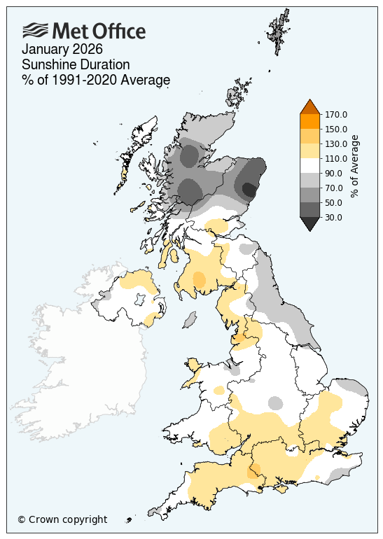
Sunshine levels for January were broadly near average nationally, but the regional picture reveals familiar north–south contrasts. Scotland and northern England saw below‑average sunshine, with northern Scotland recording 72% of average January hours and eastern Scotland 77%. Western Scotland, however, exceeded its long‑term average with 110% of average January sunshine, mirroring its relatively dry conditions.
In England, sunshine totals were mixed. England East and Northeast recorded 90% of average sunshine, while the Midlands reached 106% and East Anglia 105%. England Southwest and South Wales reached 113%, and England Southeast and Central South achieved 112%, suggesting brighter intervals between passing weather systems. Northern Ireland saw sunshine close to average at 102%.
Met Office science manager Dr Amy Doherty said: “January has been exceptionally wet because we’ve seen a very persistent Atlantic weather pattern. A strong jet stream has repeatedly steered low-pressure systems towards the UK, bringing frequent spells of rain and wind. With little opportunity for drier conditions in between, the ground has become saturated, so even moderate rainfall has had a greater impact. This succession of Atlantic systems is the main reason rainfall totals this month are well above average for many areas.”
Keep up to date with weather warnings, and you can find the latest forecast on our website, on YouTube, by following us on X and Facebook, as well as on our mobile app which is available for iPhone from the App store and for Android from the Google Play store.
