After a wintry and disruptive start to the year, Storm Goretti delivered some of the most impactful weather the UK has seen for some time and persistent snow has caused significant disruption in parts of Scotland.
From destructive winds in Cornwall to widespread snowfall across Wales and the Midlands, the past week has highlighted just how quickly winter weather can escalate.
In this week’s Deep Dive, we look back at what happened during Storm Goretti, how Met Office warnings are issued during evolving situations, and what the coming days and next week might have in store.
A winter of contrasting hazards
Snow has already played a prominent role this January, with northern Scotland seeing prolonged disruption before conditions finally began to thaw. As that thaw took place, Storm Goretti swept in, bringing very different hazards depending on where you were.
The most severe impacts occurred across Cornwall and the Isles of Scilly, where destructive winds tore through a narrow corridor on Thursday afternoon. Elsewhere, heavy rain transitioned to snow as it encountered Arctic air, leading to travel disruption, stranded vehicles and school closures across parts of Wales and the Midlands.
Yet many people across England, especially outside the southwest, saw little more than breezy conditions. That contrast has prompted questions about how weather warnings work, and why impacts can vary so much across relatively short distances.
Unsettled over the coming days, particularly on Thursday night when a developing area of low pressure tracks across the country, bringing a spell of heavy rain and strong winds 👇
— Met Office (@metoffice) January 13, 2026
Stay #WeatherAware⚠️ pic.twitter.com/Nv4nY3xyPN
How Met Office warnings work
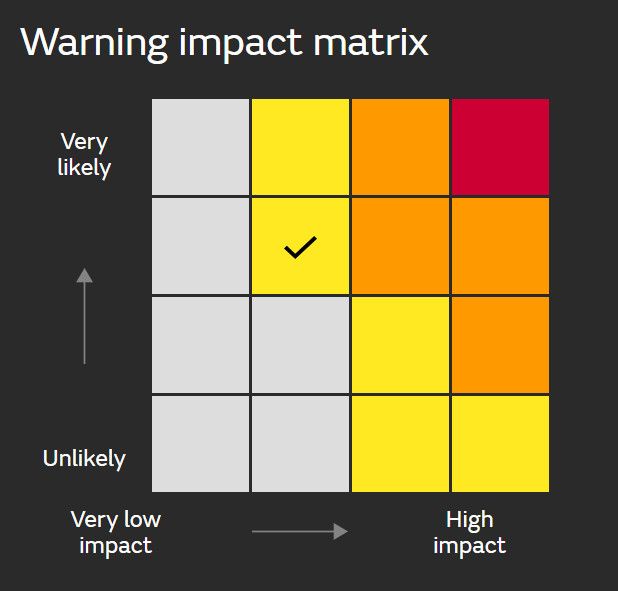
One of the most important aspects of a storm like Goretti is understanding the warnings issued ahead of it. Contrary to popular belief, warnings are not triggered by a specific weather threshold, such as a fixed wind speed or snow depth. Instead, warnings are issued based on impacts, and how likely those impacts are to occur.
This is where the Met Office warnings matrix comes in. The matrix maps impacts (from very low to high) against likelihood (also from very low to high). Where an event sits on this chart determines whether a warning is yellow, amber or red.
Yellow warnings: possible impacts
The initial yellow warning for wind and snow ahead of Storm Goretti were issued on Tuesday, 6 January, stretched from the Pennines through mid-Wales and into parts of central, and southwestern England. This covered the potential for:
- Travel delays and stranded vehicles
- Possible rail and air disruption
- Rural communities becoming cut off
- Power cuts
The emphasis, however, was on possibility. Not all areas would see accumulating snow, and the southern boundary of the snowfall was particularly uncertain due to the competing push of milder air.
That uncertainty played out: while some places saw only rain, others saw significant accumulations, especially with even modest rises in elevation.
Amber warnings: likely impacts
Where confidence increased, the yellow area was refined into an amber warning zone across mid and north Wales and the Midlands on Wednesday, 7 January. The impacts were the same as in the yellow area, but now likely rather than possible.
Snowfall in the amber region matched expectations. Official reports showed 6-7cm across parts of the Midlands, 16cm in higher areas of Wales, and social media observations suggested 20-25cm in Shropshire, accompanied by drifting.
Red warnings: high impacts, high likelihood
The most severe escalation came in Cornwall and the Isles of Scilly, where an early‑morning amber wind warning was upgraded to a red warning by 2pm on Thursday, 8 January.
This upgrade happened because the storm deepened rapidly as it was picked up by the jet stream, increasing confidence that severe and widespread impacts were imminent.
The red warning indicated:
- High likelihood of high impacts
- Danger to life from flying debris
- Damage to buildings
- Widespread power outages
- Travel disruption and road closures
Goretti delivered exactly that. St Mary’s recorded gusts of 99mph, with unofficial stations in Cornwall reporting over 110mph. Thousands of trees were brought down; 43,000 households lost power; and St Michael’s Mount saw 80% of its trees damaged.
READ MORE: Met Office weather warnings: How and why they are issued
Why the fuss if you weren’t affected?
Many people outside the southwest experienced only modest winds. But the scenes in Cornwall, roof damage, widespread transport issues, homes without water, and significant tree loss, underline why red warnings are rare and taken extremely seriously.
Looking ahead: The next low‑pressure system
Unfortunately for those still clearing up after Goretti, another area of low pressure is due toward the end of this week. It is not expected to be as intense, but there remains uncertainty about its track and depth.
Showers will continue across northern and northwestern areas on Thursday, some of which may be locally heavy and wintry over higher ground. Further south, increasing cloud will give way to persistent and at times heavy rain across much of southern and eastern parts of the UK, although there remains some uncertainty over how far north and west this rain will extend. It will become windy in the south and southeast later in the day. By Thursday night, the persistent and occasionally heavy rain will clear into the North Sea, though strong winds are possible across southeast England, with the chance of coastal gales. Elsewhere, many inland areas will turn dry and clear at first, allowing frost and fog to develop, while showers feed inland from windward coasts, becoming increasingly frequent across the southwest as the night progresses.
Regardless of the exact solution, Thursday night into Friday looks wet for many, with snow mainly confined to higher ground.
Weekend and early‑week outlook: Slowing systems and increasing gloom
As we head into the weekend, low pressure systems approaching from the Atlantic begin to slow down. Rather than sweeping through cleanly, they linger, fizzle and leave behind widespread low cloud.
The result will be:
- Bright spells and showers in the west
- Increasingly grey, overcast conditions in the east
- Patches of fog and hill fog
- A chilly feel, particularly early next week with southeasterly winds
This pattern marks the start of a shift away from the fast‑moving Atlantic regime that shaped early January.
READ MORE: Week ahead forecast: Milder conditions but heavy rain possible later in the week
Could colder weather return?
While confidence decreases beyond about 10 days ahead, ensemble modelling, drawing on more than 250 computer simulations, helps outline plausible scenarios for the end of next week.
For Wednesday 21 January, the most likely pattern (21% of ensemble members) is:
- A chilly, mostly dry southeasterly flow
- Plenty of cloud
- Temperatures slightly below average
Other less common but possible outcomes include a more pronounced cold easterly (13%) or low pressure over the UK (11%).
Looking further to the end of next week, southeasterly or easterly flows remain favoured, supported by high pressure over Scandinavia or western Russia. The precise position of that high will determine whether the UK experiences simply chilly, cloudy conditions, or something markedly colder.
What appears unlikely is a return to mild, Atlantic‑driven weather.
Keep up to date with weather warnings, and you can find the latest forecast on our website, on YouTube, by following us on X and Facebook, as well as on our mobile app which is available for iPhone from the App store and for Android from the Google Play store.