The current weather pattern shows little sign of changing, and the rain is certainly not going anywhere yet.
From a persistently south‑shifted jet stream driving the UK’s wet January, to a potentially once‑in‑a‑lifetime rainfall event unfolding across Spain and Portugal, there is no shortage of significant meteorological stories in this week’s Deep Dive. We’ll also be exploring newly released Met Office research on ensemble forecasting, with expert insight from lead author Ken Mylne.
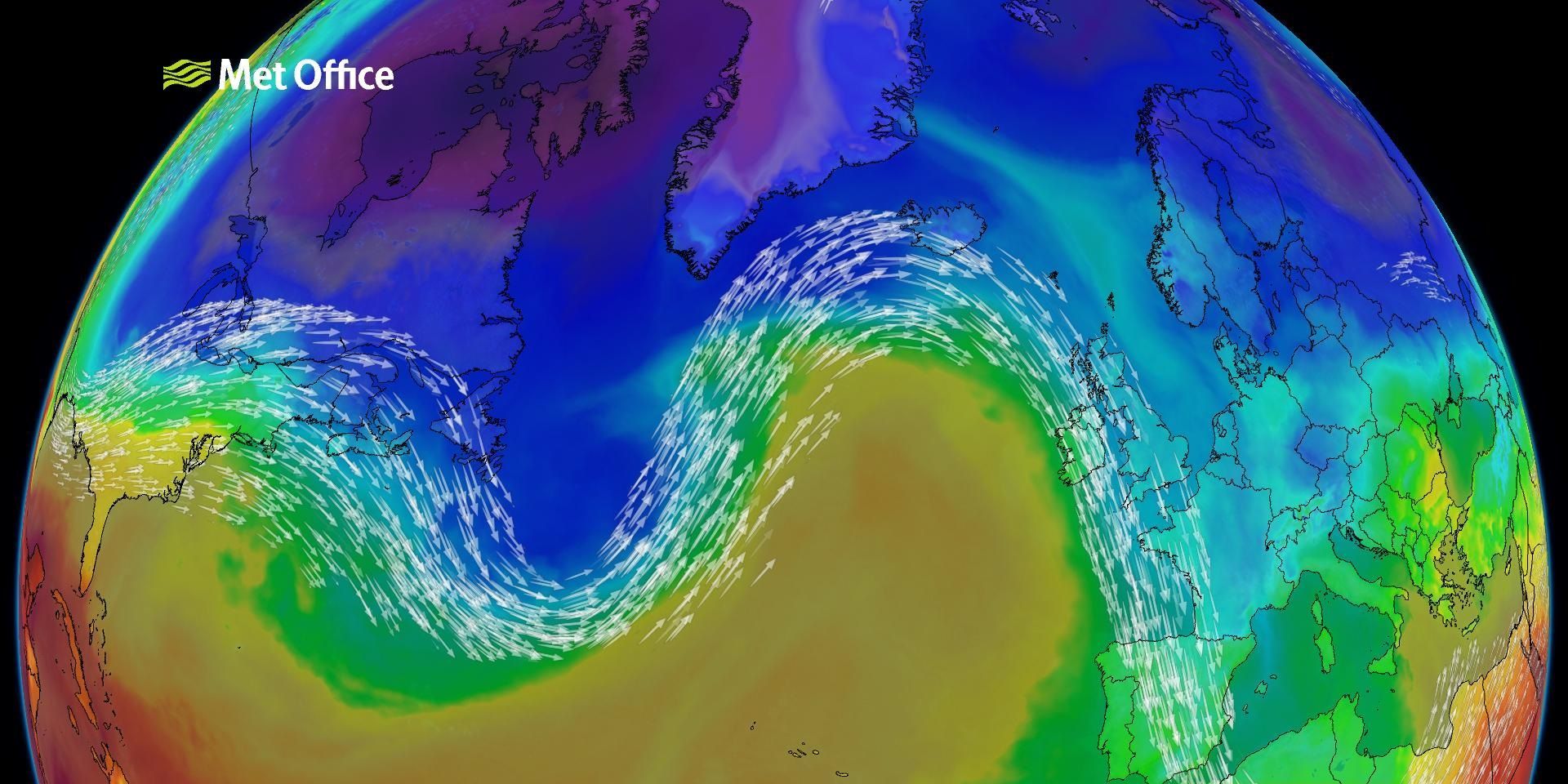
Understanding the south‑shifted jet stream
A strong, unusually southerly jet stream continues to dominate the weather pattern across the UK and much of Europe. This setup has repeatedly driven areas of low-pressure north-eastwards into the UK, contributing to a notably wet January.
Cornwall has recorded its wettest January on record, with Northern Ireland also experiencing exceptional rainfall totals. The primary driver of this powerful jet is the large temperature gradient across the Atlantic, a theme we have explored in recent weeks. But another important player is the blocking high over northeastern Europe, which is helping to hold the jet in a displaced southerly position.
The result is a conveyor belt of low‑pressure systems bringing frequent rain, strong winds, and, at times, wintry hazards. This week continues in a similar vein, with further rainfall expected, snow and freezing‑rain risks in places, and a general trend towards unsettled conditions.
READ MORE: What is the Jet Stream and how does it affect UK weather?
UK forecast highlights for the week ahead
Although low-pressure remains dominant, there are subtle shifts through the middle of the week. Milder air is expected to push into southern areas on Wednesday, creating a split across the country: persistent rain in northeastern Scotland contrasted with somewhat drier interludes elsewhere. Yellow weather warnings for snow and rain are currently in place.
However, details remain uncertain due to the influence of a developing area of low pressure to the southwest of the UK. Showers are likely to spread northwards into southern counties, while a steady stream of rain continues from the northeast. Northwestern areas may see the best of the drier spells.
Why Iberia is facing a major rainfall event
The same south‑shifted jet stream that has influenced the UK is also impacting Spain and Portugal. A series of Atlantic lows have been steered towards Iberia in recent days, and this week another large, elongated low has been named Storm Leonardo by the Portuguese Met Service. Although Leonardo will not bring storm‑force conditions to the UK, its impacts across Iberia and parts of North Africa are expected to be significant.
Heavy rainfall is forecast to affect Portugal, southern and eastern Spain, northern Morocco, and western Algeria, especially between Wednesday and Thursday. Some areas may see 500–600 mm of rain during this period, an extraordinary amount for early February.
This event differs from recent severe weather episodes such as the Valencia floods, which were driven by short‑lived but intense downpours. The current event is characterised by widespread, prolonged rainfall, with the greatest concern focused on slow‑responding river catchments.
River flooding risk: a once‑in‑a‑generation event?
Of particular concern is the Guadalquivir River basin in southern Spain, where the geography of the river system could amplify the impacts of heavy, multi‑day rainfall. Reservoir levels in the region are already high, and how these are managed over the coming days will play an important role in moderating downstream flood potential.
Data from the Copernicus Emergency Management Service, based on ECMWF ensemble rainfall forecasts, shows that projected river discharge later this week reaches thresholds associated with 1‑in‑20‑year return periods, even in the lowest‑probability ensemble members. Higher‑end scenarios approach 1‑in‑100‑year discharge levels.
In other words, confidence is high that this will be a major hydrometeorological event, with a realistic risk of exceptional river flooding, widespread infrastructure disruption, and agricultural impacts across parts of Spain and Portugal.
Preparations are already underway in affected regions, but the exact severity will still depend on rainfall totals and local reservoir‑management decisions.
How ensemble forecasting helps highlight high‑impact risks
The Met Office has been a pioneer in ensemble prediction for more than 30 years, and new research explores both the science and the public understanding of probability‑based forecasts.
Ensemble forecasting uses multiple versions of a weather model run with slightly different starting conditions. This approach helps forecasters assess uncertainty and identify low‑likelihood but high‑impact scenarios, something a single deterministic forecast cannot do.
Lead author, Ken Mylne, explained that although probability forecasts can initially appear complex, extensive research shows that people do understand them and, crucially, make better decisions when given access to uncertainty information.
Ensemble forecasting in action: lessons from the Beast from the East
A striking example of ensemble forecasting in action is the Beast from the East. Three days before the event, ensemble forecasts showed:
- High confidence in a band of snow showers down the east coast of Scotland and northeastern England, seen consistently across almost all ensemble members.
- Low confidence but high impact potential of a major snowstorm in southwest England, appearing in only a handful of members but with significant possible consequences.
This information enabled forecasters to issue early yellow warnings covering a broad area, later updated to amber and then red as confidence increased. Without ensemble data, the southwest England risk may not have been visible until much closer to the event.
READ MORE: Why has it been so rainy?
This example demonstrates how ensembles improve early‑warning capability by highlighting “high‑impact, low‑likelihood” outcomes, an essential aspect of modern impact‑based forecasting.
Improving public communication of uncertainty
Ken’s research also explored how best to present probability information to the public. Participants in a “weather game,” where people made decisions for an imaginary ice‑cream seller, consistently made better choices when given probability‑based forecasts, especially when numbers were paired with graphics.
Key findings included:
- Combining numerical values with visual symbols (e.g., chance of rain alongside a graphic) is the most effective communication method.
- The term “chance of rain” is more approachable than “probability,” which some people find off‑putting.
- Representing uncertainty visually, such as with pie charts, icon arrays, or dual‑symbol forecasts, could help people interpret medium‑range forecasts more effectively.
These ideas are especially relevant as the Met Office prepares to introduce “week‑two” forecasts, where communicating uncertainty becomes even more important because detailed hourly predictions are not feasible at longer range.
The combination of an unusually strong jet stream, persistent low pressure, and ongoing research into advanced forecasting techniques makes this an especially dynamic period for meteorology. While the UK faces yet more wet and unsettled weather, parts of Spain and Portugal are bracing for what could become a truly exceptional rainfall event.
Ensemble forecasting continues to provide forecasters with a deeper understanding of both risk and uncertainty, helping deliver more accurate, earlier, and more useful warnings to the public.
Keep up to date with weather warnings, and you can find the latest forecast on our website, on YouTube, by following us on X and Facebook, as well as on our mobile app which is available for iPhone from the App store and for Android from the Google Play store.