Air mass types
Air masses are classified into groups depending on their basic temperature and humidity characteristics.
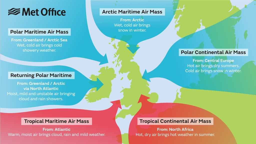
There are six main types of air masses that affect the British Isles. We classify these air masses primarily by the area in which they originate.
They are classified as continental or maritime - dependent on whether they originate over land or sea - and arctic or antarctic, equatorial, tropical, or polar, depending on the particular region in which they form.
Air masses that affect the British Isles
There are a total of six air masses that affect the British Isles.

Arctic Maritime Air Mass
- From: Arctic
- Wet, cold air brings snow in winter
Polar Continental Air Mass
- From: Central Europe
- Hot air brings dry summers
- Cold air brings snow in winter
Tropical Continental Air Mass
- From: North Africa
- Hot, dry air brings hot weather in summer
Tropical Maritime Air Mass
- From: Atlantic
- Warm, moist air brings cloud, rain and mild weather
Returning Polar Maritime
- From: Greenland / Arctic via North Atlantic
- Moist, mild and unstable air, bringing cloud and rain showers
Polar Maritime Air Mass
- From: Greenland / Arctic Sea
- Wet, cold air brings cold showery weather
Polar continental
This air mass has its origins over the snow fields of Eastern Europe and Russia and is only considered a winter (November to April) phenomena.
During the summer with the land mass considerably warmer, this air mass would be classed as a tropical continental.
The weather characteristics of this air mass depend on the length of the sea track during its passage from Europe to the British Isles: this air is inherently very cold and dry and if it reaches southern Britain with a short sea track over the English Channel, the weather is characterised by clear skies and severe frosts. With a longer sea track over the North Sea, the air becomes unstable and moisture is added giving rise to showers of rain or snow, especially near the east coast of Britain.
The lowest temperatures across the British Isles usually occur in this air mass, lower than -10 °C at night, and sometimes remaining below freezing all day.
Polar maritime
This air mass has its origins over northern Canada and Greenland and reaches the British Isles on a north-westerly air stream.
Polar maritime is the most common air mass to affect the British Isles. This air mass starts very cold and dry but during its long passage over the relatively warm waters of the North Atlantic its temperature rises rapidly and it becomes unstable to a great depth.
This air mass is characterised by frequent showers at any time of the year. In the winter months when instability (convection) is most vigorous over the sea, hail and thunder are common across much of the western and northern side of the British Isles. However, eastern Britain may see fewer showers as here the surface heating is reduced. During the summer, the reverse is true, land temperatures are higher than sea temperatures and the heaviest showers occur over eastern England.
Arctic maritime
An arctic maritime air mass has similar characteristics to a polar maritime air mass, but because of the shorter sea track the air is colder and less moist.
Arctic air is uncommon during the summer, but when it does occur it may bring heavy showers or thunderstorms and unseasonably low temperatures.
Between October and May, the air is cold enough to produce hail showers or snow, and these are most frequent over Scotland and along the coasts exposed to northerly winds.
An arctic maritime air mass has its origins over the North Pole and the Arctic Ocean.
Polar low-pressure systems forming in this air mass can sometimes lead to widespread and heavy snowfall, but otherwise inland areas remain free of cloud in the winter months. In northern Scotland, arctic maritime is usually the coldest air mass, but over the rest of Britain, this air mass is not as cold as polar continental.
Returning polar maritime
Returning polar maritime is another version of polar maritime, but this time with a longer sea track which takes the air first southwards over the North-Atlantic, the north-eastwards across the British isles.
During its passage south, the air becomes unstable and moist but on moving north-east it passes over cooler water making it stable in its lowest layers.
Although the weather across the British Isles in this air mass is largely dry, there can be extensive cloud cover.
Tropical continental
This air mass originates over North Africa and the Sahara (a warm source region). It is most common during the summer months June, July and August, although it can occur at other times of the year.
Our highest temperatures usually occur under the influence of tropical continental air (over 30 °C by day and around 15 to 20 °C at night).
Visibility is usually moderate or poor due to the air picking up pollutants during its passage over Europe and from sand particles blown into the air from Saharan dust storms. Occasionally, the Saharan dust is washed out in showers producing coloured rain and leaving cars covered in a thin layer of orange dust.
Tropical maritime
The source region for this air mass is warm waters of the Atlantic Ocean between the Azores and Bermuda. The predominant wind direction across the British Isles, in a tropical maritime air mass, is south-westerly.
Tropical maritime air is warm and moist in its lowest layers and, although unstable over its source region, during its passage over cooler waters becomes stable and the air becomes saturated. Consequently when a tropical maritime air mass reaches the British Isles it brings with it low cloud and drizzle, perhaps also fog around windward coasts and across hills. To the lee of high ground though, the cloud my break up and here the weather, particularly in the summer months, can be fine and sunny.
This is a mild air stream and during the winter month in particular, can raise the air temperature several degrees above the average.


