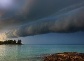
Altocumulus castellanus
Altocumulus castellanus clouds take their name from their resemblance to the turrets of castles and are often a warning of thunderstorms.
Height of base: (7,000 - 18,000 ft).
Shape: A collection of small individual clouds, sometimes with “castle” towers proceeding from the top.
Latin: altum - height; cumulus – heap; castellanus = like a castle
Precipitation: Usually a few large droplets of rain, often evaporating before they reach the ground.
What are Castellanus clouds?
Altocumulus Castellanus clouds take their name from a resemblance to the turrets of castles and are often a warning of thunderstorms.
How do Castellanus clouds form?
Like other cumulus clouds, Castellanus clouds are caused by unstable air heated from below rising rapidly, causing water droplets to condense. The difference is that, whereas cumulus or cumulonimbus clouds are triggered by instability near the surface and heat from the sea or the ground, Altocumulus Castellanus clouds occur when the instability only starts much higher up. Although the cloud shapes look small to the eye, this is only because we see them from a great distance as they are so high up.
What weather is associated with Castellanus clouds?
Castellanus clouds are associated with lightning, often jumping from cloud to cloud without getting anywhere near the ground. Seeing Castellanus clouds is often a sign that Cumulonimbus clouds are on their way, with their associated heavy showers, strong gusty winds as well as thunder and lightning.
How do we categorise Castellanus clouds?
Castellanus are a subset of Altocumulus clouds.