How much does it rain in the UK?
Find out how much rain we get in the UK and where gets the most rainfall.
Where gets the most rain?
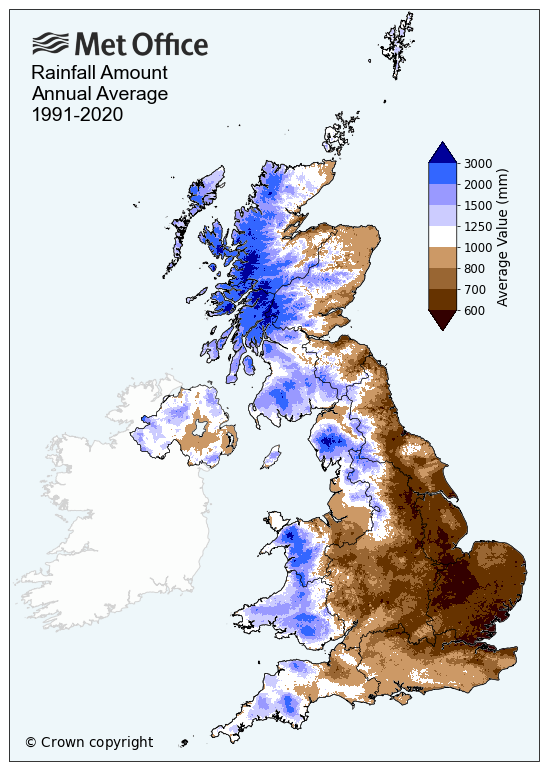
As can be seen in the map below, the wettest parts of the UK are concentrated in mountainous regions with observation sites in Snowdonia, the Lake District and the Scottish Highlands all receiving more than 4 metres of rainfall in a year.
 Other rainy parts of the UK include:
- Northwest England - especially the Lake District in Cumbria and western facing slopes of the Pennines.
- Western and Mid Wales - particularly the mountainous Snowdonia region in the north.
- Southwest England - mainly the higher elevation areas of Dartmoor, Exmoor and Bodmin Moor.
- Parts of Northern Ireland.
These areas all have common characteristics, given their high elevations (or even mountainous status) and their northern or western locations in the UK.
| Area | Rainfall (mm) |
|---|---|
|
Argyllshire |
2274.9 |
|
Dunbartonshire |
2066.5 |
|
Inverness |
2034.8 |
|
Merionethshire |
1914.0 |
|
Ross and Cromarty |
1858.1 |
|
Carnarvonshire |
1809.7 |
|
Buteshire |
1771.2 |
|
Kirkcudbrightshire |
1696.7 |
|
Westmorland |
1652.6 |
|
Brecknockshire |
1643.7 |
Why do some places get more rain than others?
The map above shows a clear divide between the northwest and southeast of the UK. The prevailing warm moist westerly winds mean that the west of the UK is more likely to receive rainfall from Atlantic weather systems, in the form of frontal rainfall. These weather systems usually move from west to east across the UK and as they do so the amount of rainfall they deposit reduces.
This is because the mountains of the northern and western UK force the prevailing westerly winds to rise, which cools the air and consequently enhances the formation of cloud and rain in these locations (this is known as orographic enhancement). Of course, frontal and orographic rainfall are not the only rainfall mechanisms, but they are the most common in the UK.