What is a Spanish plume?
A 'Spanish plume' is a weather setup which brings an increased risk of thunderstorms within an air mass which travels north from Iberia.
The storms can form over the UK, or can move towards it having developed over Spain, western France or Biscay.
What causes a Spanish plume?
There are three main ingredients which are typically involved in a Spanish plume event:
- Very warm air pushing north from the Spanish plateau on a southerly airflow. This can happen at almost any time of year but during the summer months the extra warmth and moisture lead to increased energy available for storm development
- Cooler air at height advancing from the west associated with upper troughs or cold fronts
- Strong summer sunshine heating air at and near the surface across France and the UK
What happens during a Spanish plume?
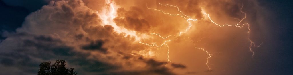
The very warm air moving northwards from Spain towards the UK will rise as hot air is less dense than cold air. As this unstable air rises it cools leading to the formation of clouds, in this case cumulonimbus or thunder clouds.
As cooler air spreads from the west instability increases and the very warm air rises through the cooler air, enhancing the formation of thunderstorms.
The very warm air from Spain forms a layer at height and acts as a lid, initially preventing warm air rising from the surface. However, as the air at the surface increases in temperature eventually it warms enough to break through this barrier and air can then rise from the surface up to the higher parts of the troposphere.
This air is very unstable and the dramatic release of energy that occurs results in the formation of cumulonimbus clouds, lightning, thunder, hail, downpours of rain and sometimes gusty winds.
These storms can last for several hours if there is enough energy and moisture to sustain the process and can form a large complex of thunderstorms known as a Mesoscale Convective System (MCS).
Spanish plumes most often affect southern areas of the UK, with southeastern and southern England most at risk. These areas are closest to the source of the warm plume of air and so it is here that the contrast between warm and cool air masses is greatest.
Spanish plume event in the UK: 17 - 21 July 2014
In July 2014, the UK experienced a series of Spanish plume events, as successive plumes of very warm, humid air moved north from Iberia and France, and were repeatedly overrun by cooler air at higher levels in the atmosphere.
The result was several outbreaks of widespread thundery activity, each of them across different areas but often including intense thunderstorms.
Between 17 - 21 July 2014, the UK experienced 62,277 lightning strikes (seen in the video below). The UK also saw the high temperatures and heavy downpours characteristic of a Spanish Plume event, with a maximum temperature of 28.5 °C on the 19th July at St James' Park in London and the recording of an unusual 45.8 mm rainfall in just one hour at Norwich Airport on 20th July (this is around half of the UK hour rainfall record).