The opening weeks of 2026 have been exceptionally wet across the UK. A strong and unusually southerly jet stream has steered a succession of low‑pressure systems towards our shores, bringing frequent rain, strong winds and, at times, wintry hazards.
The pattern has been notable not only for how often rain has arrived, but also for how slowly some fronts have cleared, leaving many places with the sense that winter has been ‘stuck on repeat’.
An exceptionally wet start to the year
January was markedly wet in several regions, including southwest England, eastern Scotland and Northern Ireland. Cornwall and County Down recorded their wettest January on record, while Northern Ireland saw its wettest January is 149 years. Across the UK, 26 stations set new monthly records for highest January rainfall. Daily records also fell: Plymouth recorded its wettest January day in 104 years, Hurn (Dorset) in 74 years and Dunkeswell (Devon) in 57 years. Each of these figures helps to demonstrate that 2026 has started not just wetter than average, but with rainfall intensities and frequencies that rival some of the most notable periods in the observing record.
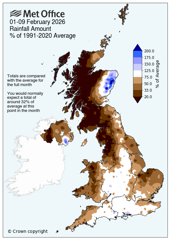
How much has it rained so far in February?
Provisional Met Office figures for February so far (up to and including 8 February) show that rainfall has continued to run ahead of schedule in many parts of the UK. The UK has already seen 37% of the average rainfall expected for the whole of February, while England has already reached 59% of its monthly average. There is a clear north–south split within England: northern England has so far seen 39% of its February average, compared with 72% in southern England. Wales has reached 39% of its February monthly average and Northern Ireland 36%, while Scotland has had 21% of its average February rainfall. Within Scotland, regional contrasts are pronounced - northern Scotland has seen just 9% so far and western Scotland 12%, while eastern Scotland has reached 59% of its full February average rainfall already.
At a county level, some areas have already exceeded their full‑month average rainfall. City of Aberdeen has reached 180% of its February average, Kincardineshire 152%, and Angus 130%. Further south, the Isle of Wight has already reached 108% of its average and Worcestershire 103%. These early‑month figures illustrate how the persistent unsettled pattern has front‑loaded rainfall totals, with some locations surpassing an entire month’s typical rainfall within the first eight days.
Consecutive wet days: where the rain barely stopped
One useful way to describe persistence is to look at consecutive wet days. From late December into early February, several observing sites recorded runs of 37 or more successive days with measurable rainfall. North Wyke in Devon logged 40 consecutive wet days from 31 December 2025 to 8 February 2026. Cardinham (Bodmin) in Cornwall also reached 40 consecutive wet days over the same period, while Astwood Bank in Hereford and Worcester matched that 40‑day run from 31 December 2025 to 8 February 2026. Two further sites recorded 37‑day runs: Liscombe in Somerset (3 January to 8 February 2026) and Camborne in Cornwall (3 January to 8 February 2026). These long sequences reflect how frequently fronts and showers have crossed the country and how rarely local drying intervals have been long enough to break the daily tally.
Feel like the rain hasn’t stopped? ☔
— Met Office (@metoffice) February 9, 2026
For some places, it really hasn’t! 😦
North Wyke, Cardinham and Astwood Bank have recorded rain every single day so far this year 🌧️ pic.twitter.com/q8DchNZQjB
Chief Forecaster Neil Armstrong said: "The past few weeks have felt relentlessly wet, with repeated bands of rain sweeping in from the Atlantic and creating increasingly saturated ground across large parts of the UK.
"This persistent unsettled pattern has been driven by a strong, south-shifted jet stream steering low pressure systems directly towards the UK. Cold plunges of air across North America have strengthened the temperature gradient across the northwest Atlantic, energising the jet, while a blocking high over northern Europe has prevented weather fronts from clearing, causing them to stall over the UK. The result has been continuous waves of rain, strong winds, and hill snow in parts of Scotland. Daily rainfall records have also fallen, with Plymouth, Hurn and Dunkeswell all experiencing their wettest January day in several decades and now, some areas have already seen their average February rainfall in just eight days."
Regional signals within the wet spell
While the unsettled theme has been widespread, regional detail matters. Southwest England has been particularly wet, consistent with repeated frontal incursions from the Atlantic and frequent orographic enhancement over higher ground. Northern Ireland has also been very wet, with local records reflecting the intensity and persistence seen there, while eastern Scotland has experienced frequent precipitation with upland snow at times. These variations align with the storm tracks favoured by the southerly‑displaced jet and the blocking pattern to the northeast.
When will the rain stop?
Short breaks in the rain have occurred, but they have not tended to last long, with new systems arriving before the ground has had time to dry out. Steven Keates is a Deputy Chief Forecaster and said: “In the near term, the unsettled theme is expected to continue, with further showers or longer spells of rain for most. We are likely to see the transition from wet and windy weather to colder, more settled conditions towards the end of the week, with Saturday looking a fine day for many. But, this reprieve doesn’t last long, as the next set of Atlantic weather fronts looks set to move in from the west at the end of the weekend.”
Impacts and context
The combination of frequent rainbands and slow‑moving fronts has kept soils saturated and rivers responsive in many catchments. Where showers and frontal waves have aligned over several days, locally intense falls have compounded totals, contributing to daily and monthly records at a number of stations. In addition, the same pattern has supported periods of strong winds, with named storms highlighting how dynamically active the atmosphere has been during this spell. Together, these factors explain why so many places have seen long runs of wet days alongside notable single‑day and whole‑month extremes.
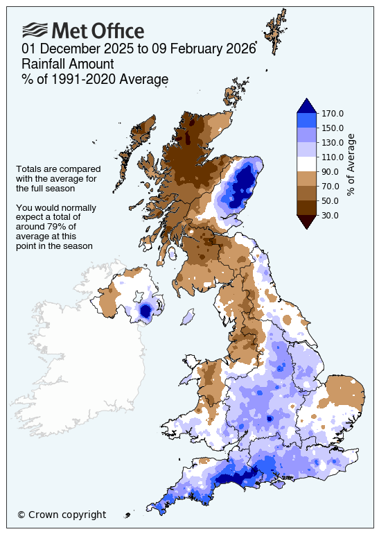
How wet has winter been so far?
Provisional Met Office figures for meteorological winter (December, January and February), up to and including 8 February, show that much of the UK has already accumulated a significant proportion of its typical seasonal rainfall. The UK has already reached 89% of its average winter rainfall, while England has already exceeded its seasonal average at 111%. Wales has seen 94% of its average winter rainfall so far, and Northern Ireland has also surpassed the seasonal benchmark at 101%. In contrast, Scotland sits at 69%, although this national figure masks marked regional differences that reflect the varied weather patterns experienced across the country this winter.
There is of coures, still more than half of February to go, with full provisional Met Office statistics released on Monday 2 March 2026.
You can find the latest forecast on our website, on YouTube, by following us on X and Facebook, as well as on our mobile app which is available for iPhone from the App store and for Android from the Google Play store.