UK Snow 2010
Many parts of the UK experienced significant snow events from late November to early December 2010. This case-study focuses on the period 28 November to 2 December.
Meteorological situation
Many parts of the UK experienced a severe snow and snow forecasts event from late November to early December 2010. The worst period was 28 November to 3 December.
The midday weather chart for 28 November is shown on the left. Pressure is high to the north of the UK and low over the south of the UK. In the northern hemisphere, air flows in a clockwise direction around high pressure systems and anticlockwise around low pressure systems. This means that the source of the air reaching the UK is Eastern Europe which is very cold in winter.
Across the north of the UK the isobars (lines of equal pressure) are closer together, indicating stronger winds.
The chart shows an occluded front lying across Southern Scotland and over the south of the UK there are some troughs.
Our 'How weather works' section gives an explanation of the different types of Weather fronts.
Air masses are bodies of air within which there is little variation in temperature or humidity. The air mass in this situation was a polar continental with winds from an easterly direction. The image on the left shows the air masses which affect the UK.
The radar image (below left) is for midday on 28 November. The weather chart (below right) is a zoomed in version of the weather chart at the top. Can you see any similarities between the weather chart and the radar image? If you look closely you the bands of snow tie in with the position of the fronts and troughs, for example the occluded front across southern Scotland ties in with a band of heavy snow.
Snow depths
During this weather event most parts of the UK experienced snow at some time. Scotland and Northern England were affected particularly badly with some parts seeing snow falling for most of the 5 day period.
The winter of 2010 saw the UK's earliest widespread winter snowfall since 1993 with snow falling as early as 24 November across NE England.
On 1 December 76cm was recorded in the Peak District. Around 40cm of snow was recorded in Rotherham and Lincolnshire. Around 30cm was recorded in Leeds.
On the night of 1 to 2 December a band of snow affected southern England. 60cm was reported on the South Downs, 56cm at Drybrook (Gloucester) with 37cm reported at Kenley in Surrey.
On 2 December a depth of 71cm was recorded at Bathgate, West Lothian.
At Met Office sites snow depths are recorded at 0900. The map above shows the snow depths at 0900 on 2 December. Areas without lying snow were few and far between.
Satellite images are extremely useful in weather forecasting. This satellite image shows the UK snow from space on 7 December, a few days after the event but you can see that the snow cover still affected much of the UK.
Temperatures
As well as disruption due to the amounts of snow, some very cold temperatures were experienced too. A minimum of -21.1°C was recorded at Altnaharra in the Scottish Highlands on 1 December.
On the morning of 3 December a minimum of -19.0°C was recorded at RAF Topcliffe in North Yorkshire and at RAF Leeming -17.9°C was recorded.
Impacts
The emergency services, transport organisations and utilities were all put under great pressure by the snow. The freezing temperatures also caused water supply problems due to burst pipes.
Transport
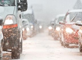
This snow event was forecast well in advance by the Met Office. Despite the advance warning the snow fell at such at rate that many roads were blocked and airports closed. The image on the right shows difficult motoring conditions in Glasgow on 28 November. On 29 November motorists were stranded overnight in Scotland and the A9 was closed for a time.
On 2 December the Forth Road Bridge was closed for over 10 hours. The first time it has ever been closed due to snow. Edinburgh airport was forced to close a number of times through the period and was closed for the best part of three days. The image below shows a council worker clearing snow from the pavements in Edinburgh. Gatwick was forced to close for two days. The secretary of State estimated that the cost of the travel disruption to the economy was £280 million per day.
Health
Sadly by 4 December seven people had died due to the severe weather. Accident and Emergency admissions always rise during this type of weather with increased admissions due to accidents and falls. The number of people suffering broken bones, fractures and sprains always rises markedly during cold spells.
Economy
The cold spell was estimated to cost the UK economy £1.6 billion (Office for National Statistics). The cold wintry spell took place in the run up to Christmas when the shops are usually busiest. Retailers were hit by lost sales. Fewer people ventured out to the shops in such extreme weather. Another aspect is that deliveries did not make it to the shops due to closed roads and many supermarket shelves looked decidedly empty. This kind of weather often leads to panic buying with people buying more food than they need in case the cold spell lasts for a long time.
Education
Around 7,000 schools were closed on 2 December. Pupils couldn't make it to school due to closed roads, etc. In the event of children with both parents working there were a lot of instances where one parent had to take time of work to look after the children who are affected by closed schools. This in turn had a knock-on effect on the economy.