Air mass source regions
The source region of an air mass defines its main characteristics.
The temperature of an air mass will depend largely on its point of origin and its subsequent journey over the land or sea. This might lead to warming or cooling by prolonged contact with a warm or cool surface.
A warm air mass is produced by prolonged contact with a warm surface, and conversely, a cold air mass is produced by prolonged contact with a cold surface. The heat transfer processes that warms or cools the air takes place slowly. It may take a week or more to warm up the air by 10 oC right through the atmosphere and for these changes to take place, a large mass of air must stagnate over a region. Parts of the Earth's surface where the air can stagnate and gradually gain properties of the underlying surface are called source regions.
The main source regions are the high pressure belts in the subtropics (giving rise to tropical air masses) and around the poles (the source for polar air masses).
Warm source regions (tropical air masses):
- Sahara Desert - warm and dry
- Tropical Oceans - warm and moist
Cold source regions (polar air masses):
- Arctic Ocean - cold and moist
- Siberia - cold and dry
- Northern Canada - cold and dry
- Southern Ocean - cold and moist
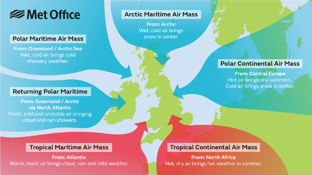
The graphic below shows the air masses that affect the UK throughout the year.