
Prolonged rainfall, cloud-laden skies, snow and even some named storms; Winter 25/26 had it all, but how well did the Met Office predict the wild weather?
Here, we take a look back at the Met Office’s forecasts through winter, how accurate they were, how they were used and how the science of forecasting advanced during the season.
How accurate were Met Office forecasts through winter?
Met Office forecast accuracy is routinely assessed in a wide variety of ways of ways, but the below figures are informed by forecast verification at around 120 sites around the UK, giving geographical spread across the UK.
Temperature forecasts are deemed to be ‘accurate’ if they’re correct within 2°C of the verifying observation.
1-day maximum temperature forecasts through winter were 96% accurate, with that figure dropping to 74% at the 5-day range.
For minimum temperatures, 83% was the level of accuracy for the 1-day range, with this dropping to 58% at 5-days.
Wind speed is assessed as accurate if it’s within five knots of the verifying observation and comes into sharp focus during the stormy winter season.
89% of wind speed forecasts at the 1-day range were within the bounds of ‘accurate’, with this only dropping to 76% at the 5-day range.
Wind direction is deemed as accurate if it’s within one compass point on a 16-point compass (22.5 degrees).
73% of 1-day wind direction forecasts were accurate, with this figure at 49% at the 5-day range.
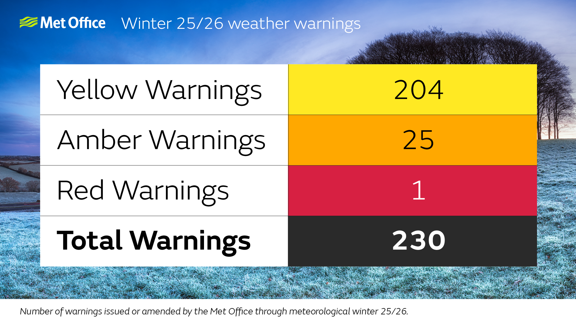
Plenty of warnings through the season
A total of 230 warnings were issued or amended during meteorological Winter 25/26, which is up from the 176 warnings from Winter 24/25. For context, the number of warnings over the season was similar to that of Winter 23/24 and not historically notable. However the persistent rainfall and strong winds Northern Ireland, southwest England and Wales experienced, along with prolonged snow and ice in Scotland, led to increased sensitivity for those communities already responding to weather hazards which continued through much of the Autumn and Winter season.
A single red weather warning was issued during the season, for Cornwall and the Isles of Scilly for Storm Goretti, while 25 Amber warnings were issued or amended, as well as 204 Yellow warnings.
Warning reaction
Met Office warnings are designed to help people, responders and businesses to prepare for and mitigate against severe weather. In order to assess their utility, the Met Office undertakes regular post-event surveys in places with the most impactful weather.
Within the Amber warning area in Scotland on 4 January, 98% of people were aware of the weather warning, with 92% of those taking action to protect themselves. 90% reported that the warning was useful.
The Scottish Environment Protection Agency (SEPA) are Scotland’s national flood forecasting, flood warning, and strategic flood risk management authority. In January, after a prolonged cold period and heavy snow in the North and North East of Scotland, a combination of persistent and heavy rain and rapid snowmelt led to a widespread increased risk of flooding, affecting communities which had already been impacted by large snow depths.
Pascal Lardet, SEPA’s Flood Warning Unit Manager, said: "It is at times like these that our working partnership with the Met Office is essential to provide timely and accurate forecasting, combining observation and forecast data and the expertise from both organisations, allowing us to issue accurate and timely information to the public and resilience colleagues across Scotland.
"The regular updates from the Met Office also mean that we can issue information as early as possible, all year round. Members of the public can sign up to the Floodline service to receive free updates for where they live, or where they’re travelling through, directly to their phone, or have a look at the three-day Scottish Flood Forecast to see what’s expected further ahead.”
Parts of the southwest of England saw significant disruption from a succession of storms over winter. The Met Office works routinely with responders, influential voices and local authorities to aid preparations and speed up recovery to severe weather.
Devon & Cornwall Police’s Chief Inspector Rob Byers reflected on the support they received during the season. He said: “We continue to benefit from a very healthy partnership with the Met Office across a number of our portfolios.
“In particular, our work in responding to dynamic major events has consistently displayed the high quality and accuracy of your forecasting data. This has allowed for timely decision making, often preventing widespread disruptions, and on occasions potentially saving lives.
“I always feel that there must be a lot of pressure at those key moments on you all. But there always remains a friendly face and an eagerness to help when we need it most.”
Advancing the science of forecasting
During Winter, the Met Office also launched its most significant scientific upgrade in more than three years, marking a major step forward for the UK’s weather and climate science capability.
These scientific advances provide clearer and more accurate forecasts, bringing them closer than ever to real-world weather.
Met Office Director of Research and Development, Professor Simon Vosper, reflected on the season’s weather and scientific advances. He said: “This winter has been another example of how important accurate weather intelligence is vital for the smooth running of the country but also the safety of people.
“The headline figures for temperatures through the season – which brought some notably cold wind and snow for some – are a particular highlight, as are the wind speed accuracy figures – which is so vital during the stormy winter season.
“The most significant advance for our forecasting science came online late in the season and helps to advance our modelling of the weather. This is a real step-change in capability which will advance forecasting performance.”
Accessing the forecast
Over 97million sessions took place on the Met Office website during the season, with 8 January proving the most popular day. This was when Storm Goretti was bringing significant impacts to parts of Cornwall and the Isles of Scilly. This brought 4.2million sessions to the Met Office website, with users keen for the latest on the upcoming system.
Over 205million Met Office app sessions took place over meteorological winter. Storm Goretti also brought the most popular day on the app, with 6.5million sessions on 8 January alone.
Met Office social media content continued to reach the public when it mattered most. A Storm Goretti special on YouTube got over 510,000 views, while the channel as a whole had around 20million views in winter, which was 85% more than the previous year’s winter.
In January 2026 alone, Met Office social media channels delivered 130.7million impressions, making it the most popular month of the winter period on social media.
