
Summer 2025 was officially the warmest summer on record for the UK. But after an extraordinary year so far – with three widespread heatwaves and numerous climate records already broken – how is meteorological Summer 2026 shaping up at the halfway point?
By 15 July, 2026 has already recorded more days above 30°C than the whole of 1976. It also became the first year on record to reach 35°C in May, June and July, while overnight temperatures have been running at record levels for this stage of the summer.
Spring 2026 was the warmest on record for England and Wales and the UK's third warmest overall. June, the first month of meteorological summer, followed suit, becoming England's warmest June on record and the second warmest for both the UK and Wales in records dating back to 1884.
Well above average temperatures
Provisional Met Office data up to and including 15 July shows the UK's average mean temperature so far this summer is 1.8°C above the long-term meteorological seasonal average.
England has been particularly warm, with mean temperatures currently 2.4°C above average, while Wales sits 2.2°C above average. Scotland and Northern Ireland have remained closer to their seasonal norms but are still running above average at 0.9°C and 1.3°C respectively.
These figures underline how persistently warm conditions have been across much of the UK, particularly in England and Wales, throughout the summer to date.

This map shows mean temperature compared with the average for the full season.
While daytime temperatures have attracted much of the attention, one of the most standout features of summer 2026 so far has been the persistently warm nights.
The graph below, based on data extending back to 1931, shows that the average daily minimum temperature (the lowest temperature recorded during the 24-hour period from 09:00 to 09:00), is currently tracking at a record high for this stage of the summer. Across the UK, minimum temperatures are averaging 1.5°C above average, reflecting a sustained period of unusually mild nights throughout June and July.

This graph shows cumulative figures rather than day-to-day averages.
By contrast, daily maximum temperatures (the highest temperature recorded during the 24-hour period from 09:00 to 09:00) are currently 2.1°C above average across the UK, although they are not currently reaching record levels for the season to date.
The most pronounced daytime warmth has been in England and Wales, where maximum temperatures are running 2.9°C and 2.7°C above average respectively. These elevated values have been driven in part by the two official heatwaves already recorded this summer.

This graph shows cumulative figures rather than day-to-day averages.
Met Office Science Manager Amy Doherty said: “We're only halfway through summer, yet 2026 has already delivered more days above 30°C than the whole of 1976 and become the first year on record to reach 35°C in May, June and July. What stands out most, however, is that the warmth hasn't been confined to the daytime, with overnight temperatures tracking at record levels for this stage of the season. The high humidity so far this summer has also been unusual, making conditions particularly uncomfortable. Taken together, these statistics make 2026 one of the most remarkable starts to a UK summer in our records."
What is driving the warmth?
Several factors have contributed to the exceptional warmth experienced so far in 2026:
- Persistent areas of high pressure have repeatedly become established close to or over the UK, bringing prolonged spells of sunshine, light winds and above-average temperatures.
- Three official heatwaves have already occurred by mid-July, helping drive exceptionally high temperatures through both late spring and summer.
- Warm nights have been a particularly significant feature, with frequent tropical nights and some of the highest June minimum temperatures on record limiting overnight cooling.
- Sea surface temperatures around the UK have been unusually high, with an ongoing marine heatwave surrounding many parts of our coastline. Warmer seas can help maintain elevated air temperatures, particularly overnight.
- Climate change continues to influence the likelihood and intensity of extreme heat. The latest State of the UK Climate report shows the UK has warmed by approximately 0.25°C per decade since the 1980s.
More heatwaves on the horizon
As the climate continues to change, the UK is likely to see more frequent and intense heatwaves. A Met Office study highlights how UK heatwaves could become longer and hotter due to escalating climate trends, with an estimated 50-50 chance of seeing 40°C again in the UK in the next 12 years. While individual weather patterns will always vary from year to year, long-term observations continue to show rising temperatures across the UK climate.
A marine heatwave continues
It's not just the atmosphere that is unusually warm this year. Surface waters around the UK continue to experience a significant marine heatwave, with temperatures around 2°C above average and locally 4-5°C warmer than normal. The intensification is linked with the three atmospheric heatwaves we have experienced so far this year, on top of long-term heat accumulation linked with climate change. Some areas south of the UK and Wales reached Category 4 'Extreme' marine heatwave conditions last week, which are rarely observed in UK waters.
Below average rainfall, with regional variation
Summer rainfall across the UK has been just below average overall, with 42% of the season’s long-term average rainfall recorded by mid-July, when we would expect around half of the season’s average rainfall.
However, rainfall patterns have varied considerably across the country. Large areas of eastern and north-eastern England have received just 26% of their average summer rainfall to date, while, in contrast, some areas of northern and western Scotland have already recorded more than half of their typical summer average.
England and Wales have each recorded only 34% of their average summer rainfall, reflecting the predominantly dry weather of recent weeks. Some locations have yet to record any measurable rainfall so far in July. These dry conditions have placed increasing pressure on water resource, contributing to the introduction of hosepipe restrictions in some parts of England.

This map shows rainfall amounts compared with the average for the full season.
Above average sunshine levels
The UK and all four nations have recorded above-average sunshine so far this summer, with Wales exceptionally sunny, seeing 68% of its whole summer average already.
This follows an exceptionally sunny spring, which was the fourth sunniest on record for the UK and third for England.

This map shows sunshine hours compared with the average for the full season.
Comparing the midpoint of summer 2026 with 2025
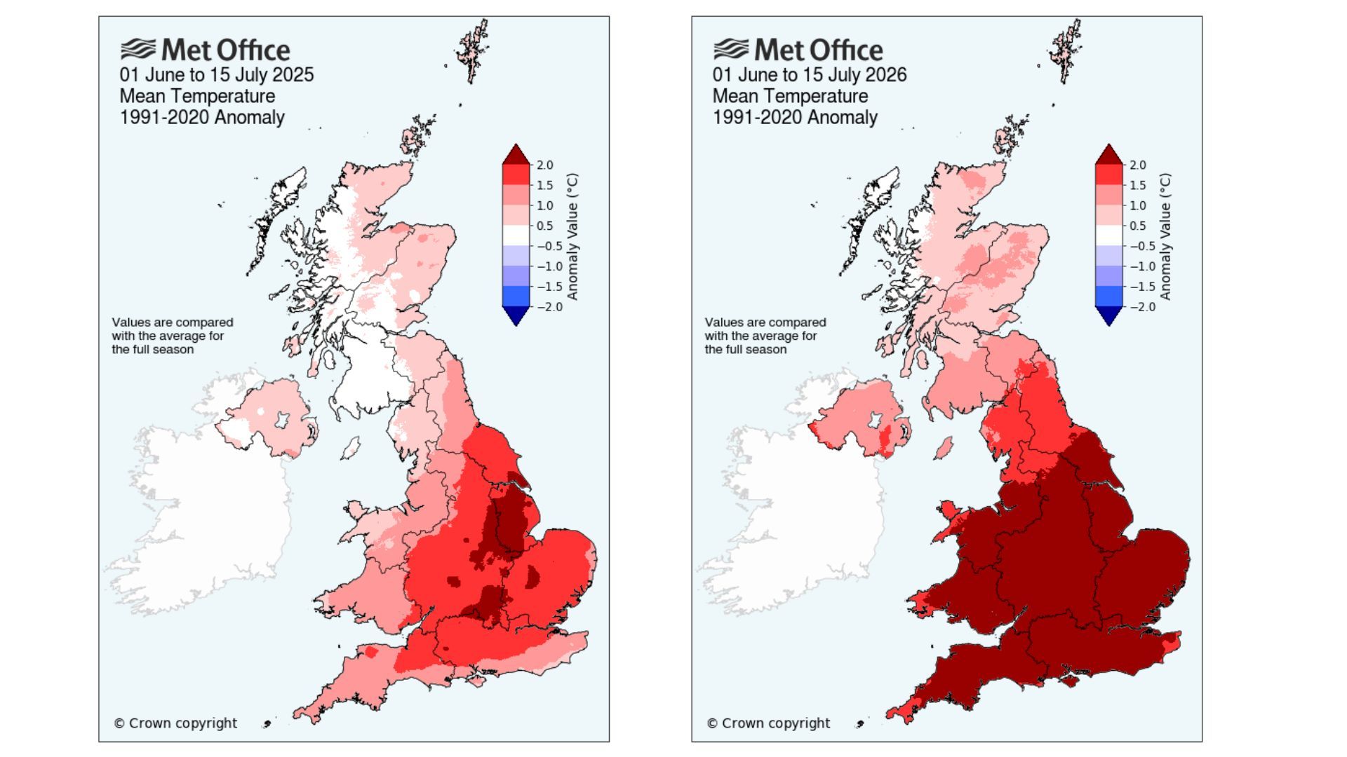
Last year, the Met Office looked at mid-meteorological summer statistics (1 June – 15 July). The comparisons for this period in 2025 and 2026 can be found below.
2026 is currently warmer than 2025 for UK mean temperature for this point in the season (1.8°C above the seasonal average compared to 1.1°C) and drier than 2025, with 42% of the full seasonal average rainfall seen compared to 45% at this point last summer.
Met Office Science Manager Amy Doherty said: “At the halfway point of meteorological summer, 2026 is running warmer and drier than the same stage of 2025, which ultimately became the UK’s warmest summer on record. While these statistics underline how remarkable the season has been so far, there is still half of summer remaining and plenty of time for the overall picture to change.”

Where does the monthly data come from?
The Met Office’s monthly climate statistics use HadUK‑Grid data to work out county, regional and UK‑wide averages. The dataset takes weather observations from across the country and interpolates them across the UK onto a 1km x 1km grid, covering every part of the UK. Some of these records stretch all the way back to 1836, meaning almost 200 years of weather data.
READ MORE: How do we know when weather records are broken?
READ MORE: What is HadUK-Grid?